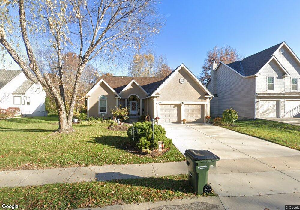
1042 Wallis Ln Leavenworth, KS 66048
Estimated Value: $350,000 - $426,000
4
Beds
3
Baths
1,627
Sq Ft
$242/Sq Ft
Est. Value
About This Home
This home is located at 1042 Wallis Ln, Leavenworth, KS 66048 and is currently estimated at $393,151, approximately $241 per square foot. 1042 Wallis Ln is a home located in Leavenworth County with nearby schools including Henry Leavenworth, Richard Warren Middle School, and Leavenworth Senior High School.
Ownership History
Date
Name
Owned For
Owner Type
Purchase Details
Closed on
May 29, 2007
Sold by
Eastham Calvin L and Eastham Barbara A
Bought by
Glenn Kathleen B
Current Estimated Value
Home Financials for this Owner
Home Financials are based on the most recent Mortgage that was taken out on this home.
Original Mortgage
$75,000
Outstanding Balance
$10,817
Interest Rate
6.17%
Mortgage Type
New Conventional
Estimated Equity
$382,334
Create a Home Valuation Report for This Property
The Home Valuation Report is an in-depth analysis detailing your home's value as well as a comparison with similar homes in the area
Home Values in the Area
Average Home Value in this Area
Purchase History
| Date | Buyer | Sale Price | Title Company |
|---|---|---|---|
| Glenn Kathleen B | $99,750 | Tri-County Title |
Source: Public Records
Mortgage History
| Date | Status | Borrower | Loan Amount |
|---|---|---|---|
| Open | Glenn Kathleen B | $75,000 |
Source: Public Records
Tax History Compared to Growth
Tax History
| Year | Tax Paid | Tax Assessment Tax Assessment Total Assessment is a certain percentage of the fair market value that is determined by local assessors to be the total taxable value of land and additions on the property. | Land | Improvement |
|---|---|---|---|---|
| 2025 | $4,493 | $39,190 | $3,422 | $35,768 |
| 2024 | $4,526 | $38,049 | $3,422 | $34,627 |
| 2023 | $4,526 | $37,671 | $3,422 | $34,249 |
| 2022 | $4,139 | $34,247 | $3,838 | $30,409 |
| 2021 | $4,284 | $33,511 | $3,838 | $29,673 |
| 2020 | $4,084 | $31,711 | $3,838 | $27,873 |
| 2019 | $3,973 | $30,572 | $3,838 | $26,734 |
| 2018 | $3,823 | $29,183 | $3,838 | $25,345 |
| 2017 | $3,851 | $29,183 | $3,838 | $25,345 |
| 2016 | $3,858 | $29,183 | $3,838 | $25,345 |
| 2015 | $3,835 | $29,183 | $3,838 | $25,345 |
| 2014 | $3,742 | $28,610 | $3,838 | $24,772 |
Source: Public Records
Map
Nearby Homes
- 1023 Ironwood Ct
- 4301 Ironwood Dr
- 4421 Grand Ct
- 4606 Park Ln
- 3804 Garland Ave
- 749 Highland Dr
- 108 Woodmoor Ct Unit Lot 100
- 3225 Meadow Rd
- 4036 Shrine Park Rd
- 1605 Shadow Dr
- 3705 Shrine Park Rd
- 728 Eisenhower Rd
- 1204 Wildwood St
- 1320 Independence Ct
- 911 Limit St
- 901 Limit St
- 840 Limit St
- 00000 Limit St
- 2104 Limit St
- 2021 Vilas St
- 1038 Wallis Ln
- 1046 Wallis Ln
- 1030 Wallis Ln
- 1047 Wallis Ln
- 4207 Grand Ave
- 1050 Wallis Ln
- 4325 Grand Ave
- 4401 Grand Ave
- 1051 Wallis Ln
- 4201 Grand Ave
- 4305 Grand Ave
- 4115 Grand Ave
- 4208 Grand Ave
- 1022 Ironwood Ct
- 4309 Grand Ave
- 1041 Oxford Ct
- 1018 Ironwood Ct
- 4200 Grand Ave
- 1037 Oxford Ct
- 4107 Grand Ave