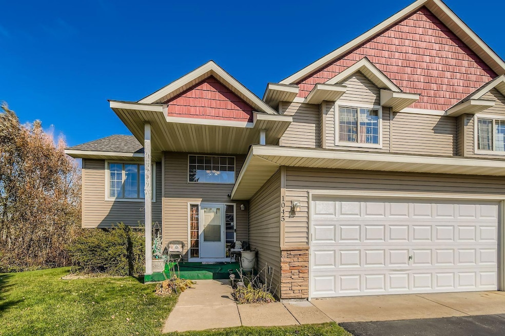
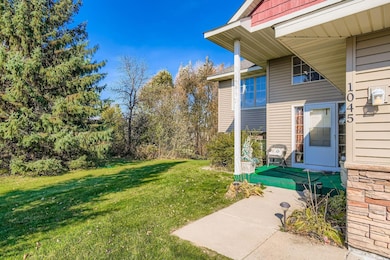
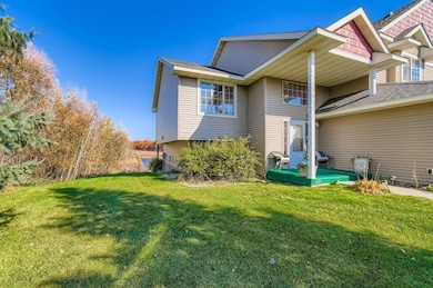
1045 162nd Ln NW Andover, MN 55304
Estimated payment $2,537/month
Highlights
- Deck
- 2 Fireplaces
- 2 Car Attached Garage
- Rum River Elementary School Rated A-
- The kitchen features windows
- 1-minute walk to Country Oaks
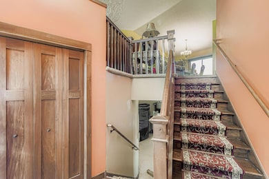
About This Home
Your Perfect Townhome Awaits!
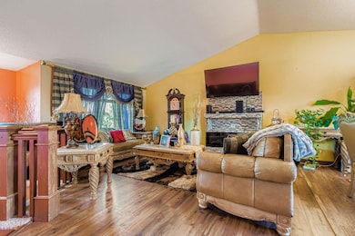
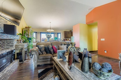
Welcome to this beautifully maintained 3-bedroom, 2-bath townhome, built in 2006 and recently updated with a brand-new roof and siding (just one month old!). Designed for modern living, the bright, open floor plan is perfect for both relaxing and entertaining.
The spacious kitchen flows seamlessly into the dining and living areas, creating a warm and inviting space you’ll love coming home to. Step outside and enjoy peaceful pond views from your private patio—ideal for morning coffee or evening unwinding.
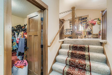
The primary suite offers plenty of space and comfort, while the additional bedrooms are perfect for guests, family, or even a home office—one currently being used as a large walk-in closet.
Conveniently located near shopping, dining, parks, and major commuter routes, this home truly has it all.
Offered at $343,400 — don’t miss your chance to make it yours!
Townhouse Details
Home Type
- Townhome
Est. Annual Taxes
- $2,991
Year Built
- Built in 2006
Lot Details
- 0.3 Acre Lot
- Lot Dimensions are 40x180x105x196
- Many Trees
HOA Fees
- $475 Monthly HOA Fees
Parking
- 2 Car Attached Garage
Home Design
- Bi-Level Home
- Vinyl Siding
Interior Spaces
- 2 Fireplaces
- Family Room
- Living Room
- Combination Kitchen and Dining Room
Kitchen
- Range
- Microwave
- Dishwasher
- The kitchen features windows
Bedrooms and Bathrooms
- 3 Bedrooms
- 2 Full Bathrooms
Laundry
- Dryer
- Washer
Finished Basement
- Basement Fills Entire Space Under The House
- Natural lighting in basement
Outdoor Features
- Deck
Utilities
- Forced Air Heating and Cooling System
- Vented Exhaust Fan
Community Details
- Association fees include ground maintenance, professional mgmt, trash
- Personal Touch Management Association, Phone Number (952) 238-1121
Listing and Financial Details
- Assessor Parcel Number 143224130029
Map
Home Values in the Area
Average Home Value in this Area
Tax History
| Year | Tax Paid | Tax Assessment Tax Assessment Total Assessment is a certain percentage of the fair market value that is determined by local assessors to be the total taxable value of land and additions on the property. | Land | Improvement |
|---|---|---|---|---|
| 2025 | $2,991 | $307,400 | $50,300 | $257,100 |
| 2024 | $2,991 | $309,000 | $50,300 | $258,700 |
| 2023 | $2,886 | $292,800 | $44,300 | $248,500 |
| 2022 | $2,777 | $318,900 | $41,400 | $277,500 |
| 2021 | $2,561 | $269,200 | $30,900 | $238,300 |
| 2020 | $2,598 | $244,400 | $29,400 | $215,000 |
| 2019 | $2,378 | $240,500 | $27,200 | $213,300 |
| 2018 | $3,065 | $217,900 | $0 | $0 |
| 2017 | $2,395 | $214,400 | $0 | $0 |
| 2016 | $2,474 | $197,500 | $0 | $0 |
| 2015 | -- | $197,500 | $14,900 | $182,600 |
| 2014 | -- | $172,700 | $11,100 | $161,600 |
Property History
| Date | Event | Price | List to Sale | Price per Sq Ft |
|---|---|---|---|---|
| 10/28/2025 10/28/25 | For Sale | $343,400 | -- | $137 / Sq Ft |
Purchase History
| Date | Type | Sale Price | Title Company |
|---|---|---|---|
| Warranty Deed | $265,000 | Liberty Title Inc | |
| Warranty Deed | $210,330 | -- | |
| Interfamily Deed Transfer | $50,000 | -- |
Mortgage History
| Date | Status | Loan Amount | Loan Type |
|---|---|---|---|
| Open | $260,200 | FHA |
Source: NorthstarMLS
MLS Number: 6810593
APN: 14-32-24-13-0029
Disclaimer: Certain information contained herein is derived from information provided by parties other than Homes.com. All information provided is deemed reliable, but is not guaranteed to be accurate and should be independently verified.
![]() Based on information submitted to the MLS GRID. All data is obtained from various sources and may not have been verified by broker or MLS GRID. Supplied Open House Information is subject to change without notice. All information should be independently reviewed and verified for accuracy. Properties may or may not be listed by the office/agent presenting the information. Some IDX listings have been excluded from this website.
Based on information submitted to the MLS GRID. All data is obtained from various sources and may not have been verified by broker or MLS GRID. Supplied Open House Information is subject to change without notice. All information should be independently reviewed and verified for accuracy. Properties may or may not be listed by the office/agent presenting the information. Some IDX listings have been excluded from this website.
The Digital Millennium Copyright Act of 1998, 17 U.S.C. § 512 (the “DMCA”) provides recourse for copyright owners who believe that material appearing on the Internet infringes their rights under U.S. copyright law. If you believe in good faith that any content or material made available in connection with our website or services infringes your copyright, you (or your agent) may send us a notice requesting that the content or material be removed, or access to it blocked.
Notices must be sent in writing by email to DMCAnotice@MLSGrid.com.
The DMCA requires that your notice of alleged copyright infringement include the following information:
(1) description of the copyrighted work that is the subject of claimed infringement;
(2) description of the alleged infringing content and information sufficient to permit us to locate the content;
(3) contact information for you, including your address, telephone number and email address;
(4) a statement by you that you have a good faith belief that the content in the manner complained of is not authorized by the copyright owner, or its agent, or by the operation of any law;
(5) a statement by you, signed under penalty of perjury, that the information in the notification is accurate and that you have the authority to enforce the copyrights that are claimed to be infringed; and
(6) a physical or electronic signature of the copyright owner or a person authorized to act on the copyright owner’s behalf. Failure to include all of the above information may result in the delay of the processing of your complaint.
- 16355 Wintergreen St NW
- 16191 Unity St NW
- 15981 Vale St NW
- 1475 162nd Ave NW
- 15725 Sycamore St NW
- 0000 168th Ln NW
- 15551 Vale St NW
- 00000 153rd Ln NW
- 0000 153rd Ln NW
- XXX Washington St NE
- 13455 Highway 65 NE
- XXX Quincy St NE
- 652 152nd Ln NW
- 1438 154th Ln NW
- 15357 Prairie Rd NW
- 1253 152nd Ave NW
- 1877 156th Ln NW
- 1769 155th Ave NW
- 17295 Ward Lake Dr NW
- 733 152nd Ave NW
- 1149 167th Ave NW
- 1753 156th Ln NW
- 2046 149th Ave NW
- 14371 Raven St NW
- 1411 190th Ave NW Unit A
- 1427 190th Ave NW Unit E
- 1427 190th Ave NW Unit A
- 2521 138th Ave NW
- 1280 185th Ave NE
- 845 Bunker Lake Blvd
- 19025 Baltimore St NE
- 14221 Inca St NW
- 3393 Northdale Blvd NW
- 370 125th Ave NE
- 1133 126th Ln NE
- 12861 Central Ave NE
- 12272 Quinn St NW
- 12233 Quinn St NW
- 12664 Central Ave NE
- 12155 Quinn St NW
