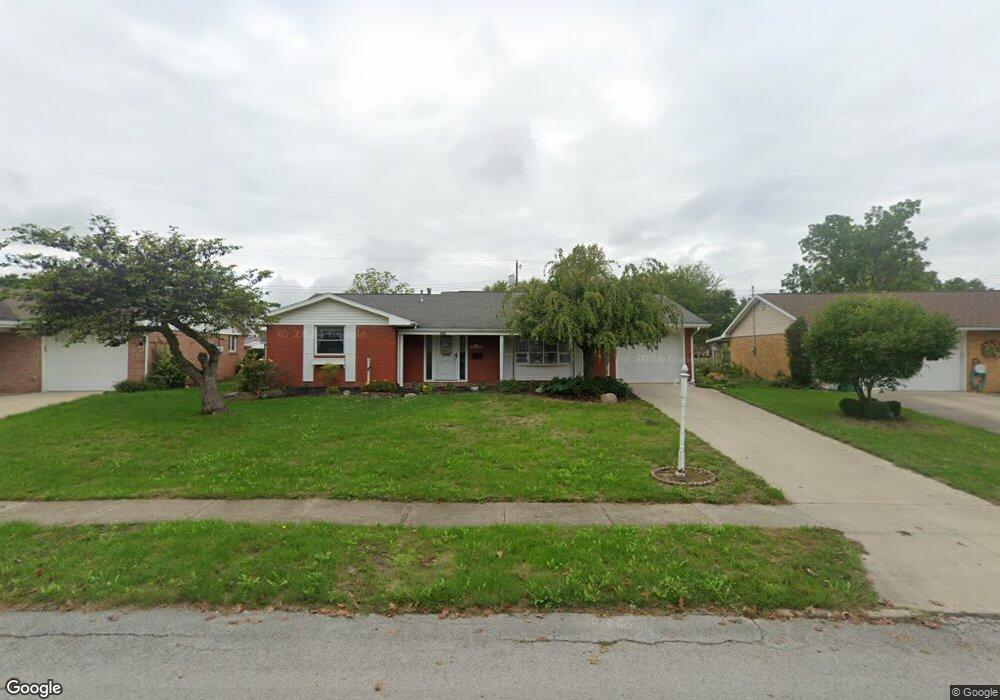
1045 Cornell Dr Lima, OH 45805
Westgate NeighborhoodEstimated Value: $150,000 - $168,719
3
Beds
2
Baths
1,488
Sq Ft
$106/Sq Ft
Est. Value
About This Home
This home is located at 1045 Cornell Dr, Lima, OH 45805 and is currently estimated at $157,180, approximately $105 per square foot. 1045 Cornell Dr is a home located in Allen County with nearby schools including Heritage Elementary School, Lima West Middle School, and Lima North Middle School.
Ownership History
Date
Name
Owned For
Owner Type
Purchase Details
Closed on
Mar 9, 2023
Sold by
Clemens David W
Bought by
Rumbaugh Properties Llc
Current Estimated Value
Home Financials for this Owner
Home Financials are based on the most recent Mortgage that was taken out on this home.
Original Mortgage
$280,000
Outstanding Balance
$260,707
Interest Rate
6.13%
Mortgage Type
New Conventional
Estimated Equity
-$103,527
Purchase Details
Closed on
Nov 27, 2020
Sold by
Estate Of Barbara S Clemens
Bought by
Clemens David W
Purchase Details
Closed on
May 1, 1978
Bought by
Clemens Barbara S
Create a Home Valuation Report for This Property
The Home Valuation Report is an in-depth analysis detailing your home's value as well as a comparison with similar homes in the area
Home Values in the Area
Average Home Value in this Area
Purchase History
| Date | Buyer | Sale Price | Title Company |
|---|---|---|---|
| Rumbaugh Properties Llc | $128,000 | -- | |
| Clemens David W | -- | None Available | |
| Clemens Barbara S | -- | -- |
Source: Public Records
Mortgage History
| Date | Status | Borrower | Loan Amount |
|---|---|---|---|
| Open | Rumbaugh Properties Llc | $280,000 |
Source: Public Records
Tax History Compared to Growth
Tax History
| Year | Tax Paid | Tax Assessment Tax Assessment Total Assessment is a certain percentage of the fair market value that is determined by local assessors to be the total taxable value of land and additions on the property. | Land | Improvement |
|---|---|---|---|---|
| 2024 | $1,632 | $44,490 | $6,440 | $38,050 |
| 2023 | $980 | $32,240 | $4,660 | $27,580 |
| 2022 | $1,001 | $32,240 | $4,660 | $27,580 |
| 2021 | $1,460 | $32,240 | $4,660 | $27,580 |
| 2020 | $811 | $24,370 | $4,450 | $19,920 |
| 2019 | $811 | $24,370 | $4,450 | $19,920 |
| 2018 | $782 | $24,370 | $4,450 | $19,920 |
| 2017 | $769 | $23,420 | $4,450 | $18,970 |
| 2016 | $774 | $23,420 | $4,450 | $18,970 |
| 2015 | $853 | $23,420 | $4,450 | $18,970 |
| 2014 | $853 | $24,920 | $4,690 | $20,230 |
| 2013 | $831 | $24,920 | $4,690 | $20,230 |
Source: Public Records
Map
Nearby Homes
- 102 Charwood Dr
- 858 Mackenzie Dr
- 1753 Leland Ave
- 1730 Homeward Ave
- 1407 Latham Ave
- 1580 W Robb Ave
- 00 Homeward Ave
- 514 N Cable Rd
- 1517 Allentown Rd
- 1607 W Wayne St
- 1918 Oakland Pkwy
- 1206 Rice Ave
- 1541 Oakland Pkwy
- 1641 Whitehall Dr
- 1004 Sherman Ave
- 1120 Richie Ave
- 1630 W Market St
- 2129 Reinell Ave
- 2050 W Market St
- 2225 N Cable Rd