M
Seller's Agent in 2025
Melissa Darling
Douglas Elliman Real Estate - Park Plaza
1 in this area
11 Total Sales
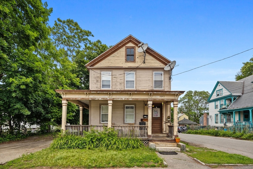
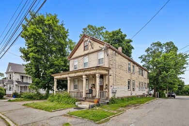
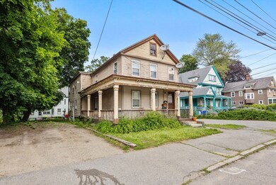

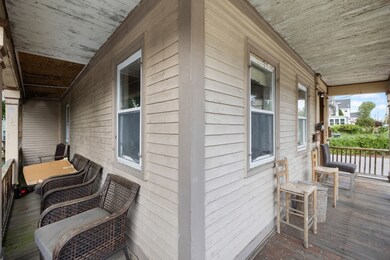
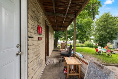

Welcome to 1045 Middlesex St, Lowell, MA 01851, a unique property full of potential, offering an excellent chance for both investors and owner-occupants. This corner lot features four bedrooms and two bathrooms spread across two units. The second unit is currently tenant-occupied and in updated condition, while the first unit is ready for your personal touches. This property also boasts 4 off-street parking spots as well as a newer roof. You'll love the covered, wrap-around front porch, perfect for morning coffee. Priced for your improvements, this opportunity is not to be missed for those seeking an investment. Lowell offers a vibrant community with local amenities to cater to a diverse range of interests. From the thriving arts scene to the numerous parks and recreation facilities, there's something for everyone. **INVITING HIGHEST AND BEST OFFERS BY MONDAY, JULY 14 AT 5PM**
Last Agent to Sell the Property
Douglas Elliman Real Estate - Park Plaza Listed on: 07/08/2025

| Date | Type | Sale Price | Title Company |
|---|---|---|---|
| Quit Claim Deed | $435,000 | -- | |
| Deed | $435,000 | -- | |
| Deed | $4,492 | -- | |
| Deed | $4,492 | -- | |
| Deed | $4,492 | -- |
| Date | Status | Loan Amount | Loan Type |
|---|---|---|---|
| Open | $479,000 | Purchase Money Mortgage | |
| Closed | $479,000 | New Conventional | |
| Previous Owner | $185,200 | No Value Available | |
| Previous Owner | $11,300 | No Value Available |
| Date | Event | Price | List to Sale | Price per Sq Ft |
|---|---|---|---|---|
| 09/09/2025 09/09/25 | Sold | $435,000 | +3.6% | $194 / Sq Ft |
| 07/17/2025 07/17/25 | Pending | -- | -- | -- |
| 07/08/2025 07/08/25 | For Sale | $420,000 | -- | $187 / Sq Ft |
| Year | Tax Paid | Tax Assessment Tax Assessment Total Assessment is a certain percentage of the fair market value that is determined by local assessors to be the total taxable value of land and additions on the property. | Land | Improvement |
|---|---|---|---|---|
| 2025 | $6,926 | $603,300 | $171,000 | $432,300 |
| 2024 | $6,383 | $535,900 | $153,900 | $382,000 |
| 2023 | $5,926 | $477,100 | $133,800 | $343,300 |
| 2022 | $5,482 | $432,000 | $121,600 | $310,400 |
| 2021 | $5,081 | $377,500 | $105,800 | $271,700 |
| 2020 | $4,581 | $342,900 | $92,500 | $250,400 |
| 2019 | $4,299 | $306,200 | $85,600 | $220,600 |
| 2018 | $3,964 | $275,500 | $78,000 | $197,500 |
| 2017 | $3,745 | $251,000 | $70,900 | $180,100 |
| 2016 | $3,469 | $228,800 | $67,500 | $161,300 |
| 2015 | $3,246 | $209,700 | $69,100 | $140,600 |
| 2013 | $3,031 | $201,900 | $82,600 | $119,300 |
M
Seller's Agent in 2025
Melissa Darling
Douglas Elliman Real Estate - Park Plaza
1 in this area
11 Total Sales
Source: MLS Property Information Network (MLS PIN)
MLS Number: 73400858
APN: LOWE-000102-004085-001045
Disclaimer: Certain information contained herein is derived from information provided by parties other than Homes.com. All information provided is deemed reliable, but is not guaranteed to be accurate and should be independently verified.
![]() The property listing data and information, or the Images, set forth herein were provided to MLS Property Information Network, Inc. from third party sources, including sellers, lessors and public records, and were compiled by MLS Property Information Network, Inc. The property listing data and information, and the Images, are for the personal, non-commercial use of consumers having a good faith interest in purchasing or leasing listed properties of the type displayed to them and may not be used for any purpose other than to identify prospective properties which such consumers may have a good faith interest in purchasing or leasing. MLS Property Information Network, Inc. and its subscribers disclaim any and all representations and warranties as to the accuracy of the property listing data and information, or as to the accuracy of any of the Images, set forth herein.
The property listing data and information, or the Images, set forth herein were provided to MLS Property Information Network, Inc. from third party sources, including sellers, lessors and public records, and were compiled by MLS Property Information Network, Inc. The property listing data and information, and the Images, are for the personal, non-commercial use of consumers having a good faith interest in purchasing or leasing listed properties of the type displayed to them and may not be used for any purpose other than to identify prospective properties which such consumers may have a good faith interest in purchasing or leasing. MLS Property Information Network, Inc. and its subscribers disclaim any and all representations and warranties as to the accuracy of the property listing data and information, or as to the accuracy of any of the Images, set forth herein.
Ask me questions while you tour the home.