


1045 Par Dr NE Townsend, GA 31331
Estimated payment $4,794/month
Highlights
- Docks
- RV Access or Parking
- Clubhouse
- Spa
- Gated Community
- Attic
About This Home
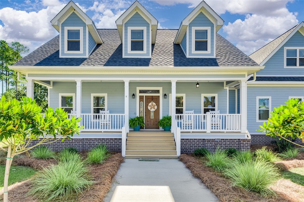
Welcome Home to 1045 Par Drive, located in the private gated community of Coopers at Shellman Bluff. Situated on a half-acre lot, this newly painted and roofed Lowcountry home offers 3,700 +/- heated square footage of beautifully designed living space. There are 6 spacious bedrooms, along with 3 full baths and a half bath located in the 7th oversized bonus room that can be used as another bedroom, home gym or media/game room. The open concept on the first floor allows for a high ceiling in the living room and foyer creating an abundance of natural light flowing through. There is a designated dining room, with a wet bar and wine cooler for entertaining guest, that also connects to the kitchen. The primary bedroom and en suite can be found on the first floor, along with 2 other bedrooms and a shared bath. Off the back of the house is a screened in back porch with plenty of room for a couple of oversized porch swings, making you contemplate where you want to sleep for the night! There is a fire pit to enjoy good camaraderie with family and friends and a hot tub for the cool nights and long days to get in and just relax. HOME HIGHLIGHTS: Quartz countertops, tiled backsplash, LVP flooring throughout entire home, custom hand railing, custom cabinets, LG kitchen appliances, tankless hot water heater, outdoor grounds irrigation, invisible fencing, fire pit, 8-person hot tub, front and back covered porch, whole under house encapsulation with spray foam and a dehumidifier and spray foam and a dehumidifier in the attic! I invite you to come and see for yourself! The community amenities are to include: a gated community, boat/RV storage yard, multiple ponds, plenty of road way to walk/run, bike or ride the golf cart, community clubhouse to utilize for gatherings and a community dock for mooring and watching the days end sunsets! Nearby airports are Brunswick, Jacksonville and Savannah. Sapelo Hammock Golf course interwinds through the community and is open to the public!
Home Details
Home Type
- Single Family
Year Built
- Built in 2008
Lot Details
- 0.52 Acre Lot
- Sprinkler System
- Zoning described as Res Single
HOA Fees
- $63 Monthly HOA Fees
Parking
- 2 Car Garage
- Garage Door Opener
- RV Access or Parking
Home Design
- Asphalt Roof
- HardiePlank Type
Interior Spaces
- 3,771 Sq Ft Home
- 2-Story Property
- Ceiling Fan
- Double Pane Windows
- Insulated Doors
- Screened Porch
- Vinyl Flooring
- Crawl Space
- Pull Down Stairs to Attic
- Washer and Dryer Hookup
Kitchen
- Breakfast Area or Nook
- Kitchen Island
Bedrooms and Bathrooms
- 6 Bedrooms
Eco-Friendly Details
- Energy-Efficient Windows
- Energy-Efficient Insulation
- Energy-Efficient Doors
Pool
- Spa
- Heated Pool
Outdoor Features
- Docks
- Fire Pit
Schools
- Todd Grant Elementary School
- Mcintosh Middle School
- Mcintosh Academy High School
Utilities
- Central Heating and Cooling System
- Programmable Thermostat
- Underground Utilities
- Septic Tank
Listing and Financial Details
- Assessor Parcel Number 0072J 0049
Community Details
Overview
- Association fees include road maintenance
- Coopers Point HOA
- Cooper's Point Subdivision
Amenities
- Picnic Area
- Clubhouse
- Community Storage Space
Recreation
- Community Pool
Security
- Gated Community
Map
Home Values in the Area
Average Home Value in this Area
Tax History
| Year | Tax Paid | Tax Assessment Tax Assessment Total Assessment is a certain percentage of the fair market value that is determined by local assessors to be the total taxable value of land and additions on the property. | Land | Improvement |
|---|---|---|---|---|
| 2024 | $6,271 | $226,040 | $8,000 | $218,040 |
| 2023 | $5,935 | $213,200 | $6,000 | $207,200 |
| 2022 | $2,933 | $105,360 | $4,000 | $101,360 |
| 2021 | $3,452 | $129,920 | $4,000 | $125,920 |
| 2020 | $2,218 | $83,480 | $10,000 | $73,480 |
| 2019 | $2,167 | $81,560 | $10,000 | $71,560 |
| 2018 | $2,167 | $81,560 | $10,000 | $71,560 |
| 2017 | $3,283 | $117,800 | $10,000 | $107,800 |
| 2016 | $3,205 | $114,880 | $14,000 | $100,880 |
| 2015 | $3,170 | $114,240 | $10,000 | $104,240 |
| 2014 | $3,122 | $112,215 | $10,000 | $102,215 |
Property History
| Date | Event | Price | List to Sale | Price per Sq Ft |
|---|---|---|---|---|
| 11/13/2025 11/13/25 | For Sale | $799,900 | -- | $212 / Sq Ft |
Purchase History
| Date | Type | Sale Price | Title Company |
|---|---|---|---|
| Warranty Deed | $310,000 | -- | |
| Deed | $74,900 | -- |
Source: Golden Isles Association of REALTORS®
MLS Number: 1657969
APN: 0072J-0049
Disclaimer: Certain information contained herein is derived from information provided by parties other than Homes.com. All information provided is deemed reliable, but is not guaranteed to be accurate and should be independently verified.
![]() IDX information is provided exclusively for personal, non-commercial use, and may not be used for any purpose other than to identify prospective properties consumers may be interested in purchasing. Information is deemed reliable but not guaranteed.
IDX information is provided exclusively for personal, non-commercial use, and may not be used for any purpose other than to identify prospective properties consumers may be interested in purchasing. Information is deemed reliable but not guaranteed.
- xx Sapelo Park Dr NE
- Lot 111 Mulligan Dr NE
- 7272 Shellman Bluff Rd NE Unit 14
- 7272 Shellman Bluff Rd NE Unit 21
- 7272 Shellman Bluff Rd NE
- 1186 Coopers Point Dr NE
- 1079 Mayflower Rd NE
- 1033 Mayflower Rd NE Unit A
- 7389 Shellman Bluff Rd NE
- Lot 266 NE Coopers Point Dr NE
- Lot 130 Sapelo Park Dr NE
- Lot 129 Sapelo Park NE
- 1069 Shellman Hammock Dr NE
- 642 NE Dune Meadow Dr
- 1017 NE Village Green Dr
- Lot 617 Coopers Landing Dr NE
- LOT 230 Coopers Landing Dr NE
- LOT 239 Coopers Landing Dr NE
- Lot 210 Coopers Landing Dr NE
- Lot 618 Coopers Landing Dr NE
- 1201 Floyd Dr NE
- 1168 Lang Ln NE
- 1998 Raleigh Rd NE
- 1518 Swamp Rd
- 1552 Swamp Rd
- 77 Yellow Bluff Rd
- 59 Anglers Edge Dr
- 94 Fishtales Dr
- 86 Fishtales Dr
- 132 Tondee Way
- 29 Lake Pamona Rd
- 1040 Seaboard Ave SW
- 1263 Blount Crossing Rd SE
- 1634 Ashantilly Dr
- 101 Haven Ct
- 1101 Florida St
- 8576 E B Cooper Hwy
- 178 Summit Cir
- 5316 Lewis Frasier Rd
- 113 Walton (Hwy17) Rd Unit D
