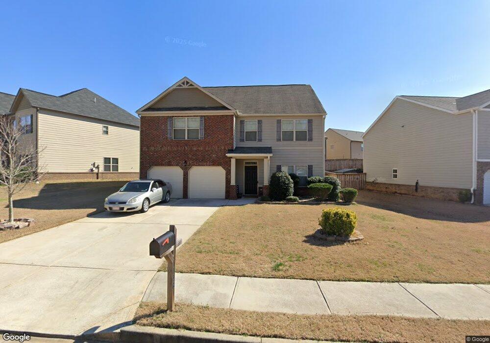
1046 Lear Dr Unit 349 Locust Grove, GA 30248
Estimated Value: $302,000 - $380,000
5
Beds
4
Baths
1,476
Sq Ft
$236/Sq Ft
Est. Value
About This Home
This home is located at 1046 Lear Dr Unit 349, Locust Grove, GA 30248 and is currently estimated at $348,119, approximately $235 per square foot. 1046 Lear Dr Unit 349 is a home located in Henry County with nearby schools including Locust Grove Elementary School, Locust Grove Middle School, and Locust Grove High School.
Ownership History
Date
Name
Owned For
Owner Type
Purchase Details
Closed on
Jul 13, 2018
Sold by
Dr Horton Inc
Bought by
Owens Michelle T and Lett Sade D
Current Estimated Value
Purchase Details
Closed on
Aug 18, 2017
Sold by
Not Provided
Bought by
Dr Horton Inc
Purchase Details
Closed on
Jul 14, 2014
Sold by
Heritage Bank
Bought by
Neda Investments Llc
Create a Home Valuation Report for This Property
The Home Valuation Report is an in-depth analysis detailing your home's value as well as a comparison with similar homes in the area
Home Values in the Area
Average Home Value in this Area
Purchase History
| Date | Buyer | Sale Price | Title Company |
|---|---|---|---|
| Owens Michelle T | $219,200 | -- | |
| Dr Horton Inc | $472,000 | -- | |
| Neda Investments Llc | $428,000 | -- |
Source: Public Records
Tax History Compared to Growth
Tax History
| Year | Tax Paid | Tax Assessment Tax Assessment Total Assessment is a certain percentage of the fair market value that is determined by local assessors to be the total taxable value of land and additions on the property. | Land | Improvement |
|---|---|---|---|---|
| 2025 | $4,342 | $157,960 | $16,000 | $141,960 |
| 2024 | $4,342 | $138,080 | $16,000 | $122,080 |
| 2023 | $3,798 | $145,480 | $21,200 | $124,280 |
| 2022 | $3,652 | $117,240 | $21,200 | $96,040 |
| 2021 | $3,160 | $96,200 | $21,200 | $75,000 |
| 2020 | $3,168 | $86,440 | $12,000 | $74,440 |
| 2019 | $3,131 | $84,040 | $12,000 | $72,040 |
| 2018 | $311 | $10,000 | $10,000 | $0 |
| 2016 | $283 | $7,760 | $7,760 | $0 |
| 2015 | $190 | $5,040 | $5,040 | $0 |
| 2014 | $91 | $2,400 | $2,400 | $0 |
Source: Public Records
Map
Nearby Homes
- 231 Ferguson Ave
- 1064 Lear Dr
- 239 Ferguson Ave
- 565 Carleton Place
- 143 Massey Ln
- 269 Baumgard Way
- 188 Sophie Cir
- 150 Aster Ave
- Cali Plan at Cedar Ridge - Locust Grove Station
- Belfort Plan at Cedar Ridge - Locust Grove Station
- Galen Plan at Cedar Ridge - Locust Grove Station
- Hayden Plan at Cedar Ridge - Locust Grove Station
- Packard Plan at Cedar Ridge - Locust Grove Station
- Flora Plan at Cedar Ridge - Locust Grove Station
- Penwell Plan at Cedar Ridge - Locust Grove Station
- 380 Higgins Rd
- 501 Vervain Dr
- 198 Aster Ave
- 194 Aster Ave
- 505 Vervain Dr
- 1046 Lear Dr
- 1044 Lear Dr
- 1044 Lear Dr Unit 350
- 1169 Werre Way
- 1165 Werre Way
- 1042 Lear Dr
- 1042 Lear Dr Unit 351
- 1159 Werre Way
- 1045 Lear Dr
- 1043 Lear Dr
- 1047 Lear Dr
- 1041 Lear Dr
- 1040 Lear Dr
- 1040 Lear Dr Unit 352
- 1155 Werre Way Unit 371
- 1155 Werre Way
- 1049 Lear Dr
- 1039 Lear Dr
- 1172 Werre Way Unit 343
- 1172 Werre Way