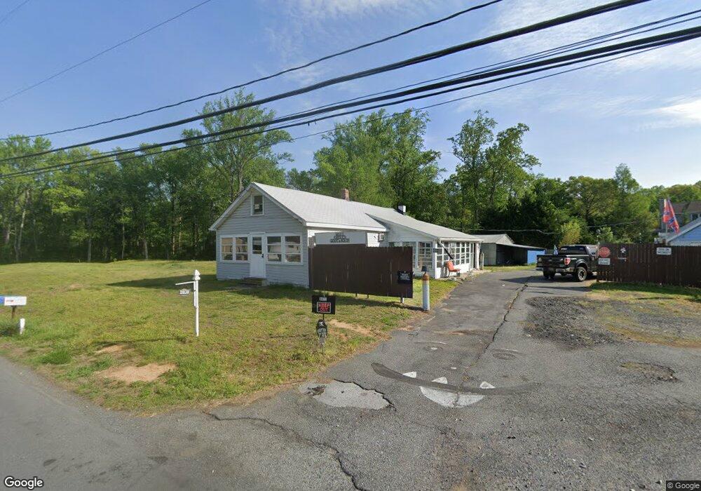
1047 Grears Corner Rd Townsend, DE 19734
Estimated Value: $268,000 - $342,000
2
Beds
1
Bath
1,225
Sq Ft
$248/Sq Ft
Est. Value
About This Home
This home is located at 1047 Grears Corner Rd, Townsend, DE 19734 and is currently estimated at $303,214, approximately $247 per square foot. 1047 Grears Corner Rd is a home located in New Castle County with nearby schools including Townsend Elementary School, Cantwell's Bridge Middle School, and Odessa High School.
Ownership History
Date
Name
Owned For
Owner Type
Purchase Details
Closed on
Sep 26, 2008
Sold by
Huffer Glenn E and Daniels Allen S
Bought by
Hegwood Robert
Current Estimated Value
Home Financials for this Owner
Home Financials are based on the most recent Mortgage that was taken out on this home.
Original Mortgage
$188,700
Outstanding Balance
$126,142
Interest Rate
6.54%
Mortgage Type
FHA
Estimated Equity
$177,072
Create a Home Valuation Report for This Property
The Home Valuation Report is an in-depth analysis detailing your home's value as well as a comparison with similar homes in the area
Home Values in the Area
Average Home Value in this Area
Purchase History
| Date | Buyer | Sale Price | Title Company |
|---|---|---|---|
| Hegwood Robert | $199,900 | None Available |
Source: Public Records
Mortgage History
| Date | Status | Borrower | Loan Amount |
|---|---|---|---|
| Open | Hegwood Robert | $188,700 |
Source: Public Records
Tax History
| Year | Tax Paid | Tax Assessment Tax Assessment Total Assessment is a certain percentage of the fair market value that is determined by local assessors to be the total taxable value of land and additions on the property. | Land | Improvement |
|---|---|---|---|---|
| 2024 | $2,210 | $52,800 | $16,300 | $36,500 |
| 2023 | $1,878 | $52,800 | $16,300 | $36,500 |
| 2022 | $1,891 | $52,800 | $16,300 | $36,500 |
| 2021 | $1,868 | $52,800 | $16,300 | $36,500 |
| 2020 | $2,347 | $52,800 | $16,300 | $36,500 |
| 2019 | $1,710 | $52,800 | $16,300 | $36,500 |
| 2018 | $1,646 | $52,800 | $16,300 | $36,500 |
| 2017 | $1,576 | $52,800 | $16,300 | $36,500 |
| 2016 | $1,440 | $52,800 | $16,300 | $36,500 |
| 2015 | $1,400 | $52,800 | $16,300 | $36,500 |
| 2014 | $1,397 | $52,800 | $16,300 | $36,500 |
Source: Public Records
Map
Nearby Homes
- 0 Blackbird Station Rd Unit DENC2096526
- 0 Dexter Corner Rd Unit DENC2075584
- 1211 Dexter Corner Rd
- 0 Lot 6 Ratledge Rd
- 341 Coralroot Dr
- 342 Coralroot Dr
- 340 Coralroot Dr
- 631 Commerce St
- 902 Vandyke Greenspring Rd
- 306 Lattomus St
- 416 Bellflower Way Unit PENNSBURY PLAN
- 418 Bellflower Way Unit MONTCHANIN PLAN
- 420 Bellflower Way Unit MERION PLAN
- 422 Bellflower Way Unit CHALFONT PLAN
- 109 New Discovery Rd
- 6147 Summit Bridge Rd
- 355 Masseys Church Rd
- 308 Gray St
- 735 Tracy Cir
- 112 Hidden Creek Blvd
- 1049 Grears Corner Rd
- 1044 Grears Corner Rd
- 1048 Grears Corner Rd
- 108 Naomi Ln
- 1038 Grears Corner Rd
- 110 Naomi Ln
- 1059 Grears Corner Rd
- 106 Naomi Ln
- 1068 Grears Corner Rd
- 109 Naomi Ln
- 1060 Grears Corner Rd
- 1027 Grears Corner Rd
- 104 Naomi Ln
- 1069 Grears Corner Rd
- 107 Naomi Ln
- 107 Naomi Ln
- 107 Naomi Ln
- 107 Naomi Ln
- 1012 Grears Corner Rd
- 615 Blackbird Station Rd
Your Personal Tour Guide
Ask me questions while you tour the home.