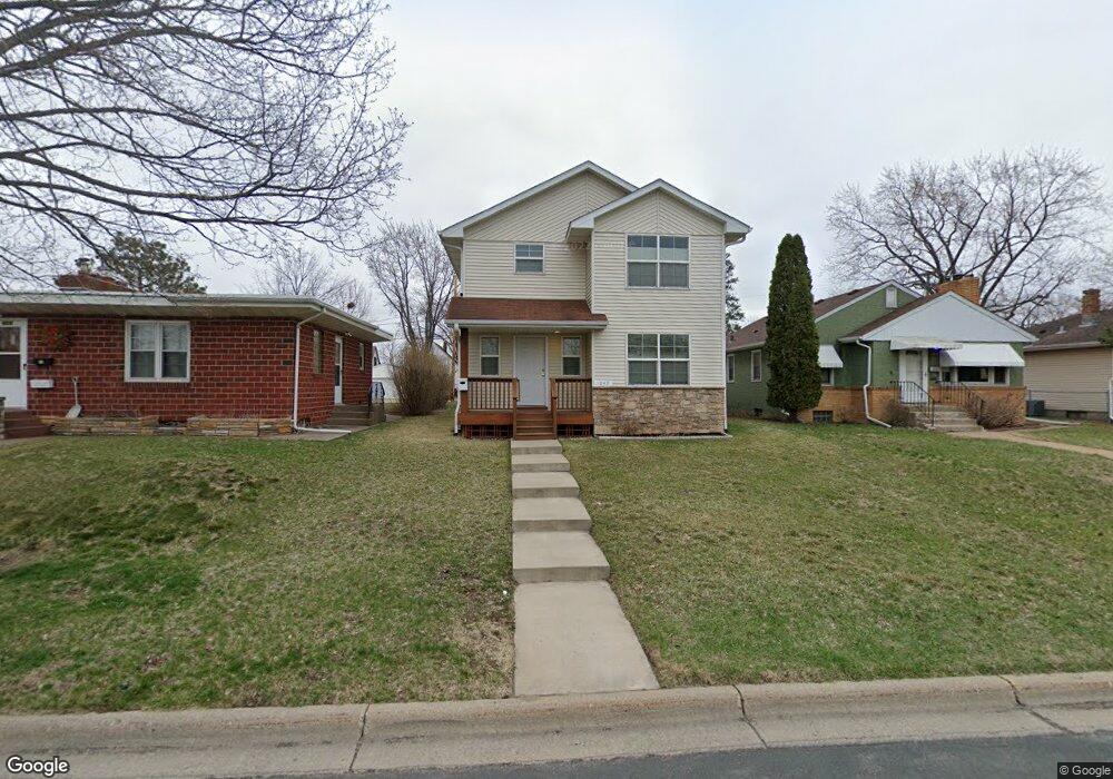
1049 6th Ave S South Saint Paul, MN 55075
Estimated Value: $305,000 - $393,000
3
Beds
3
Baths
1,536
Sq Ft
$220/Sq Ft
Est. Value
About This Home
This home is located at 1049 6th Ave S, South Saint Paul, MN 55075 and is currently estimated at $337,546, approximately $219 per square foot. 1049 6th Ave S is a home located in Dakota County with nearby schools including Kaposia Education Center Elementary, South St. Paul Secondary, and Discovery Charter School.
Ownership History
Date
Name
Owned For
Owner Type
Purchase Details
Closed on
Dec 15, 2005
Sold by
Linder Homes Inc
Bought by
Swoboda John G and Swoboda Linda C
Current Estimated Value
Purchase Details
Closed on
Oct 1, 2004
Sold by
Virnala Douglas and Virnala Susan
Bought by
Housing & Redevelopment Authority Of The
Purchase Details
Closed on
Feb 22, 1993
Sold by
Robertson Marily
Bought by
Virnala Douglas and Virnala Susan
Create a Home Valuation Report for This Property
The Home Valuation Report is an in-depth analysis detailing your home's value as well as a comparison with similar homes in the area
Home Values in the Area
Average Home Value in this Area
Purchase History
| Date | Buyer | Sale Price | Title Company |
|---|---|---|---|
| Swoboda John G | $257,900 | -- | |
| Housing & Redevelopment Authority Of The | $119,900 | -- | |
| Virnala Douglas | $44,000 | -- |
Source: Public Records
Tax History Compared to Growth
Tax History
| Year | Tax Paid | Tax Assessment Tax Assessment Total Assessment is a certain percentage of the fair market value that is determined by local assessors to be the total taxable value of land and additions on the property. | Land | Improvement |
|---|---|---|---|---|
| 2024 | $4,230 | $304,800 | $57,100 | $247,700 |
| 2023 | $4,230 | $309,800 | $57,400 | $252,400 |
| 2022 | $3,448 | $307,100 | $57,400 | $249,700 |
| 2021 | $3,298 | $259,800 | $49,900 | $209,900 |
| 2020 | $3,154 | $245,300 | $47,500 | $197,800 |
| 2019 | $2,827 | $241,200 | $45,200 | $196,000 |
| 2018 | $2,824 | $210,700 | $41,100 | $169,600 |
| 2017 | $2,679 | $202,600 | $39,200 | $163,400 |
| 2016 | $2,571 | $189,200 | $35,600 | $153,600 |
| 2015 | $2,469 | $154,055 | $29,758 | $124,297 |
| 2014 | -- | $156,344 | $29,843 | $126,501 |
| 2013 | -- | $136,397 | $25,516 | $110,881 |
Source: Public Records
Map
Nearby Homes
- 233 Richmond St W
- 1127 9th Ave S
- 1215 8th Ave S
- 928 8th Ave S
- 235 9th St S
- 151 Park St W
- 100 W Warburton St
- 101 Frost St W
- 5472 Bryce Ave
- 4970 Boyd Ave
- 1436 5th Ave S
- 1434 8th Ave S
- 1456 6th Ave S
- 137 South St E
- 4898 Bitterman Path Unit 9101
- 519 8th Ave S
- 526 9th Ave S
- 533 1st Ave S
- 5938 Burke Trail
- 531 12th Ave S
- 1053 6th Ave S
- 1053 1053 6th Ave S
- 1045 6th Ave S
- 1059 6th Ave S
- 1039 6th Ave S
- 1039 1039 6th Ave S
- 1050 5th Ave S
- 1052 5th Ave S
- 1044 5th Ave S
- 1050 1050 5th-Avenue-s
- 1050 1050 5th Ave S
- 1040 5th Ave S
- 1056 5th Ave S
- 1033 6th Ave S
- 1101 6th Ave S
- 1050 6th Ave S
- 1038 5th Ave S
- 1056 6th Ave S
- 1042 6th Ave S
- 1105 6th Ave S