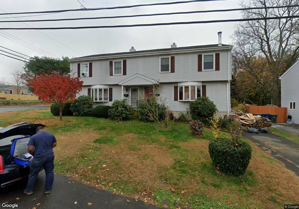
105 Benson St Bridgeport, CT 06606
Brooklawn-Saint Vincent NeighborhoodEstimated Value: $353,074 - $450,000
3
Beds
2
Baths
1,499
Sq Ft
$262/Sq Ft
Est. Value
About This Home
This home is located at 105 Benson St, Bridgeport, CT 06606 and is currently estimated at $392,769, approximately $262 per square foot. 105 Benson St is a home located in Fairfield County with nearby schools including Blackham School, Central High School, and Assumption Catholic School.
Ownership History
Date
Name
Owned For
Owner Type
Purchase Details
Closed on
Oct 4, 2024
Sold by
Nickerson Raymond
Bought by
Nickerson Terri L
Current Estimated Value
Purchase Details
Closed on
Jun 19, 1987
Sold by
Bazyli Cap
Bought by
Nickerson Raymond
Home Financials for this Owner
Home Financials are based on the most recent Mortgage that was taken out on this home.
Original Mortgage
$144,000
Interest Rate
10.54%
Mortgage Type
Purchase Money Mortgage
Create a Home Valuation Report for This Property
The Home Valuation Report is an in-depth analysis detailing your home's value as well as a comparison with similar homes in the area
Home Values in the Area
Average Home Value in this Area
Purchase History
| Date | Buyer | Sale Price | Title Company |
|---|---|---|---|
| Nickerson Terri L | -- | None Available | |
| Nickerson Terri L | -- | None Available | |
| Nickerson Terri L | -- | None Available | |
| Nickerson Raymond | $160,000 | -- |
Source: Public Records
Mortgage History
| Date | Status | Borrower | Loan Amount |
|---|---|---|---|
| Previous Owner | Nickerson Raymond | $144,000 |
Source: Public Records
Tax History Compared to Growth
Tax History
| Year | Tax Paid | Tax Assessment Tax Assessment Total Assessment is a certain percentage of the fair market value that is determined by local assessors to be the total taxable value of land and additions on the property. | Land | Improvement |
|---|---|---|---|---|
| 2025 | $5,977 | $137,562 | $30,552 | $107,010 |
| 2024 | $5,977 | $137,562 | $30,552 | $107,010 |
| 2023 | $5,977 | $137,562 | $30,552 | $107,010 |
| 2022 | $5,977 | $137,562 | $30,552 | $107,010 |
| 2021 | $5,977 | $137,562 | $30,552 | $107,010 |
| 2020 | $4,614 | $85,460 | $15,980 | $69,480 |
| 2019 | $4,614 | $85,460 | $15,980 | $69,480 |
| 2018 | $4,646 | $85,460 | $15,980 | $69,480 |
| 2017 | $4,646 | $85,460 | $15,980 | $69,480 |
| 2016 | $4,646 | $85,460 | $15,980 | $69,480 |
| 2015 | $5,305 | $125,700 | $28,990 | $96,710 |
| 2014 | $5,305 | $125,700 | $28,990 | $96,710 |
Source: Public Records
Map
Nearby Homes
- 150 Alexander Dr
- 125 Alexander Dr
- 11 Myron Ave
- 241 Sampson St
- 2625 Park Ave Unit 12L
- 2625 Park Ave Unit 5N
- 2675 Park Ave Unit 3
- 2675 Park Ave Unit 22
- 201 High Ridge Dr
- 76 Suburban Ave
- 681 Westfield Ave
- 2445 Park Ave Unit 23
- 105 Tremont Ave Unit E
- 105 Tremont Ave Unit B
- 203 Wayne St
- 485 Westfield Ave
- 252 Harlem Ave Unit B6
- 252 Harlem Ave Unit B5
- 3200 Park Ave Unit 11C2
- 3200 Park Ave Unit 11E2
- 107 Benson St
- 453 High Ridge Dr Unit 455
- 453 High Ridge Dr Unit 453-455
- 115 Benson St Unit 117
- 117 Benson St
- 96 Benson St
- 450 High Ridge Dr Unit 452
- 110 Benson St
- 86 Benson St
- 120 Benson St
- 80 Benson St
- 435 High Ridge Dr
- 130 Benson St
- 331 Truman St
- 313 Truman St
- 341 Truman St
- 301 Truman St
- 311 Truman St
- 417 High Ridge Dr
- 351 Truman St