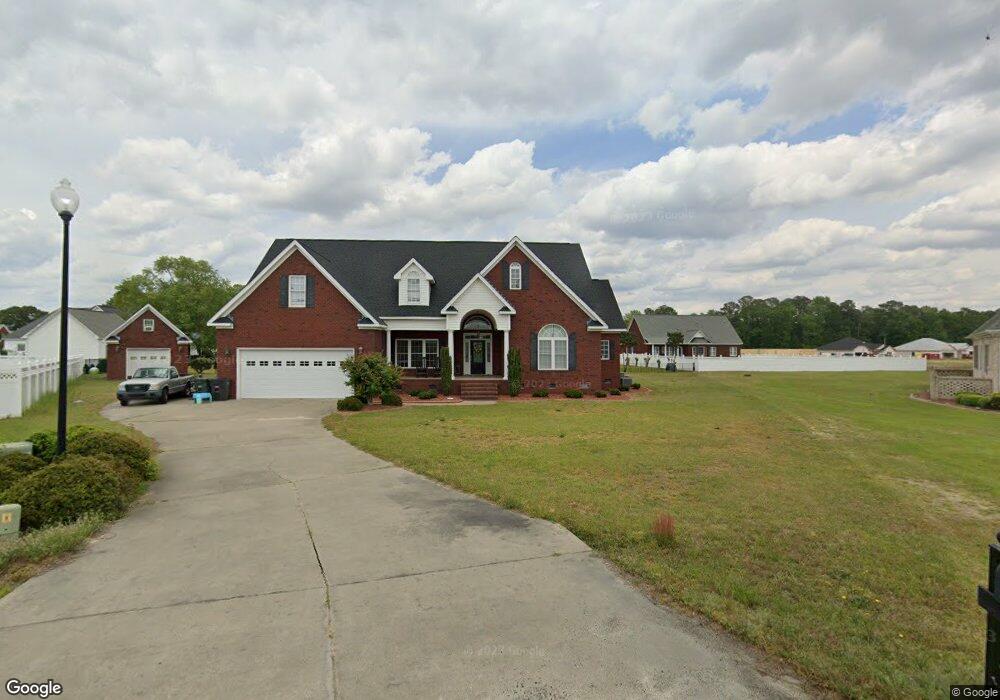
105 Blake Ct La Grange, NC 28551
Estimated Value: $372,000 - $404,000
4
Beds
3
Baths
3,100
Sq Ft
$125/Sq Ft
Est. Value
About This Home
This home is located at 105 Blake Ct, La Grange, NC 28551 and is currently estimated at $387,698, approximately $125 per square foot. 105 Blake Ct is a home located in Lenoir County with nearby schools including La Grange Elementary School, E.B. Frink Middle School, and North Lenoir High School.
Ownership History
Date
Name
Owned For
Owner Type
Purchase Details
Closed on
Sep 14, 2015
Sold by
Pate Phyllis Williams and Andrews Phyllis Williams
Bought by
Herring Scott David and Wood Michelle Katherine
Current Estimated Value
Home Financials for this Owner
Home Financials are based on the most recent Mortgage that was taken out on this home.
Original Mortgage
$171,200
Outstanding Balance
$68,672
Interest Rate
3.97%
Mortgage Type
New Conventional
Estimated Equity
$319,026
Purchase Details
Closed on
Feb 21, 2011
Sold by
Schilf Michael J and Schilf Patricia A
Bought by
Oceanus Capital Llc
Purchase Details
Closed on
Jan 17, 2007
Sold by
Sutton Developers Inc
Bought by
Schilf Michael J and Schilf Patricia A
Home Financials for this Owner
Home Financials are based on the most recent Mortgage that was taken out on this home.
Original Mortgage
$200,000
Interest Rate
6.07%
Mortgage Type
New Conventional
Create a Home Valuation Report for This Property
The Home Valuation Report is an in-depth analysis detailing your home's value as well as a comparison with similar homes in the area
Home Values in the Area
Average Home Value in this Area
Purchase History
| Date | Buyer | Sale Price | Title Company |
|---|---|---|---|
| Herring Scott David | -- | None Available | |
| Oceanus Capital Llc | $270,000 | -- | |
| Schilf Michael J | $297,000 | None Available |
Source: Public Records
Mortgage History
| Date | Status | Borrower | Loan Amount |
|---|---|---|---|
| Open | Herring Scott David | $171,200 | |
| Previous Owner | Schilf Michael J | $200,000 |
Source: Public Records
Tax History Compared to Growth
Tax History
| Year | Tax Paid | Tax Assessment Tax Assessment Total Assessment is a certain percentage of the fair market value that is determined by local assessors to be the total taxable value of land and additions on the property. | Land | Improvement |
|---|---|---|---|---|
| 2025 | $3,509 | $349,676 | $22,500 | $327,176 |
| 2024 | $3,570 | $259,228 | $24,000 | $235,228 |
| 2023 | $3,570 | $259,228 | $24,000 | $235,228 |
| 2022 | $3,570 | $259,228 | $24,000 | $235,228 |
| 2021 | $3,570 | $259,228 | $24,000 | $235,228 |
| 2020 | $3,570 | $259,228 | $24,000 | $235,228 |
| 2019 | $3,570 | $259,228 | $24,000 | $235,228 |
| 2018 | $3,531 | $259,228 | $24,000 | $235,228 |
| 2017 | $3,544 | $259,228 | $24,000 | $235,228 |
| 2014 | -- | $288,166 | $24,000 | $264,166 |
| 2013 | $3,703 | $288,166 | $24,000 | $264,166 |
| 2011 | -- | $288,166 | $24,000 | $264,166 |
Source: Public Records
Map
Nearby Homes
- 805 Madison Ann Dr
- 3619 S Caswell St
- 6272 Highway 70 E
- 4725 Packhouse Rd
- 210 Wood St
- 201 Wood St
- 202 Wood St
- 208 Wood St
- 217 Wood St
- 204 Wood St
- 205 Wood St
- 206 Wood St
- Hayden Plan at Blair Ridge
- Freeport Plan at Blair Ridge
- Cali Plan at Blair Ridge
- Belhaven Plan at Blair Ridge
- 614 S Caswell St
- 219 Wood St
- 101 Forest Dr
- 202 E Washington St
- 102 Blake Ct
- 103 Blake Ct
- 811 Madison Ann Dr
- 813 Madison Ann Dr
- 809 Madison Ann Dr
- 103 Bryan Square
- 815 Madison Ann Dr
- 401 Madison Ann Dr
- 309 Madison Ann Dr
- 403 Madison Ann Dr
- 807 Madison Ann Dr
- 807 Madison Ann Dr Unit Lot 81
- 807 Madison Ann Dr Unit Lot 48
- 101 Bryan Square
- 307 Madison Ann Dr
- 104 Bryan Square
- 407 Madison Ann Dr
- 812 Madison Ann Dr
- 814 Madison Ann Dr
- 810 Madison Ann Dr