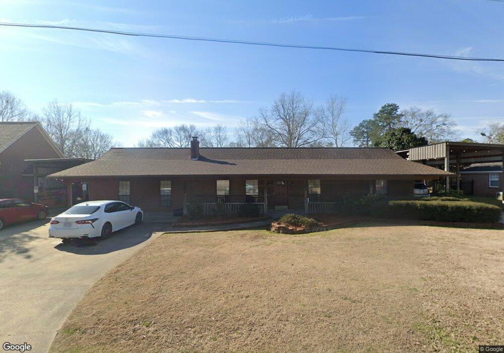
105 Crows Nest Cir Decatur, MS 39327
Estimated Value: $181,000 - $284,000
--
Bed
2
Baths
2,546
Sq Ft
$88/Sq Ft
Est. Value
About This Home
This home is located at 105 Crows Nest Cir, Decatur, MS 39327 and is currently estimated at $224,462, approximately $88 per square foot. 105 Crows Nest Cir is a home located in Newton County with nearby schools including Newton County Elementary School, Newton County High School, and Newton County Academy.
Ownership History
Date
Name
Owned For
Owner Type
Purchase Details
Closed on
Jul 3, 2007
Sold by
Mcneil Carl F and Mcneil Amanda D
Bought by
Mcneil Carl F and Mcneil Amanda D
Current Estimated Value
Home Financials for this Owner
Home Financials are based on the most recent Mortgage that was taken out on this home.
Original Mortgage
$108,000
Interest Rate
6.03%
Create a Home Valuation Report for This Property
The Home Valuation Report is an in-depth analysis detailing your home's value as well as a comparison with similar homes in the area
Home Values in the Area
Average Home Value in this Area
Purchase History
| Date | Buyer | Sale Price | Title Company |
|---|---|---|---|
| Mcneil Carl F | -- | -- |
Source: Public Records
Mortgage History
| Date | Status | Borrower | Loan Amount |
|---|---|---|---|
| Closed | Mcneil Carl F | $108,000 |
Source: Public Records
Tax History Compared to Growth
Tax History
| Year | Tax Paid | Tax Assessment Tax Assessment Total Assessment is a certain percentage of the fair market value that is determined by local assessors to be the total taxable value of land and additions on the property. | Land | Improvement |
|---|---|---|---|---|
| 2024 | -- | $17,120 | $0 | $0 |
| 2023 | -- | $17,120 | $0 | $0 |
| 2022 | $0 | $17,120 | $0 | $0 |
| 2021 | $2,090 | $16,008 | $0 | $0 |
| 2020 | $2,090 | $15,917 | $0 | $0 |
| 2019 | $2,161 | $15,917 | $0 | $0 |
| 2018 | $2,090 | $15,917 | $0 | $0 |
| 2017 | $1,950 | $15,091 | $0 | $0 |
| 2016 | $1,654 | $13,218 | $0 | $0 |
| 2015 | -- | $13,218 | $0 | $0 |
| 2014 | -- | $13,218 | $0 | $0 |
Source: Public Records
Map
Nearby Homes
- 18159 Mississippi 15
- 18159 Hwy 15
- 625 Midway Rd
- 13470 Highway 503
- 0 Stratton Rd
- 0 Eastside Dr
- 2708 Beaver Creek Rd
- 107 Adeline Ln
- Allgood Rd
- 000 Pleasant Ridge Rd
- 66 Pete Freeman Rd
- 4188 Greenland Rd
- 0 Edwards Rd
- 21959 Hwy 80
- 3212 Erin Lucern Rd
- 704 Decatur St
- 309 Conehatta Rd
- 1421 Chesney Town Rd
- 0 Hugh Hudnall Rd
- 202 New Ireland St
- 127 Crows Nest Cir
- 87 Crows Nest Cir
- 51 Crows Nest Cir
- 37 Crows Nest Cir
- 291 Crows Nest Cir
- 108 Crows Nest Cir
- 19 Crows Nest Cir
- 292 Crows Nest Cir
- 153 Crows Nest Cir
- 249 Crows Nest Cir
- 199 Crows Nest Cir
- 80 Crows Nest Cir
- 58 Crows Nest Cir
- 68 Crows Nest Cir
- 36 Crows Nest Cir
- 46 Crows Nest Cir
- 247 Crows Nest Cir
- 215 Crows Nest Cir
- 104 Crows Nest Cir
- 227 Crows Nest Cir