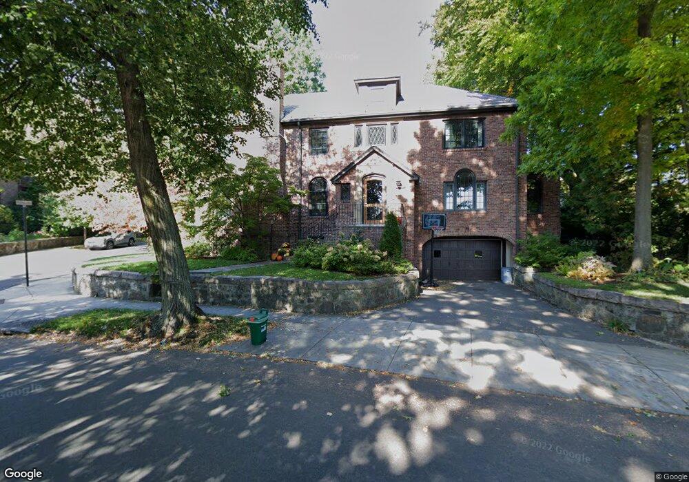
105 Gardner Rd Brookline, MA 02445
Washington Square NeighborhoodEstimated Value: $2,642,000 - $3,042,000
4
Beds
3
Baths
2,824
Sq Ft
$1,016/Sq Ft
Est. Value
About This Home
This home is located at 105 Gardner Rd, Brookline, MA 02445 and is currently estimated at $2,869,037, approximately $1,015 per square foot. 105 Gardner Rd is a home located in Norfolk County with nearby schools including Pierce School, Brookline High School, and Match Charter Public School.
Ownership History
Date
Name
Owned For
Owner Type
Purchase Details
Closed on
Jun 1, 2011
Sold by
Gardner Road Nt
Bought by
Hughes Bryan R and Hughes Pollyanna C
Current Estimated Value
Home Financials for this Owner
Home Financials are based on the most recent Mortgage that was taken out on this home.
Original Mortgage
$520,000
Outstanding Balance
$362,156
Interest Rate
4.85%
Mortgage Type
Purchase Money Mortgage
Estimated Equity
$2,506,881
Create a Home Valuation Report for This Property
The Home Valuation Report is an in-depth analysis detailing your home's value as well as a comparison with similar homes in the area
Home Values in the Area
Average Home Value in this Area
Purchase History
| Date | Buyer | Sale Price | Title Company |
|---|---|---|---|
| Hughes Bryan R | $1,090,000 | -- |
Source: Public Records
Mortgage History
| Date | Status | Borrower | Loan Amount |
|---|---|---|---|
| Open | Hughes Bryan R | $520,000 |
Source: Public Records
Tax History
| Year | Tax Paid | Tax Assessment Tax Assessment Total Assessment is a certain percentage of the fair market value that is determined by local assessors to be the total taxable value of land and additions on the property. | Land | Improvement |
|---|---|---|---|---|
| 2025 | $26,968 | $2,732,300 | $1,667,500 | $1,064,800 |
| 2024 | $25,709 | $2,631,400 | $1,603,300 | $1,028,100 |
| 2023 | $22,907 | $2,297,600 | $1,290,800 | $1,006,800 |
| 2022 | $22,298 | $2,188,200 | $1,229,300 | $958,900 |
| 2021 | $20,619 | $2,104,000 | $1,182,000 | $922,000 |
| 2020 | $18,750 | $1,984,100 | $1,074,600 | $909,500 |
| 2019 | $17,706 | $1,889,600 | $1,023,400 | $866,200 |
| 2018 | $16,166 | $1,708,900 | $852,900 | $856,000 |
| 2017 | $15,927 | $1,612,000 | $804,500 | $807,500 |
| 2016 | $15,699 | $1,506,600 | $751,900 | $754,700 |
| 2015 | $15,037 | $1,408,000 | $702,700 | $705,300 |
| 2014 | $14,491 | $1,272,300 | $585,600 | $686,700 |
Source: Public Records
Map
Nearby Homes
- 84 Winthrop Rd Unit 1
- 84 Winthrop Rd
- 15 Colbourne Crescent Unit 2
- 71 Greenough St Unit 71-1
- 101 Winthrop Rd Unit 1
- 89 University Rd
- 4 Fairbanks St Unit 2
- 90 Addington Rd Unit 1
- 90 Addington Rd Unit 2
- 140 Sumner Rd Unit 1
- 57 University Rd Unit 3
- 24 Blake Rd
- 1490 Beacon St Unit 4
- 115 Clark Rd
- 20 Claflin Rd Unit A
- 80 Vernon St Unit 1-A
- 80 Vernon St Unit 2B
- 80 Vernon St Unit PHA
- 80 Vernon St Unit 3A
- 80 Vernon St Unit 3B
Your Personal Tour Guide
Ask me questions while you tour the home.