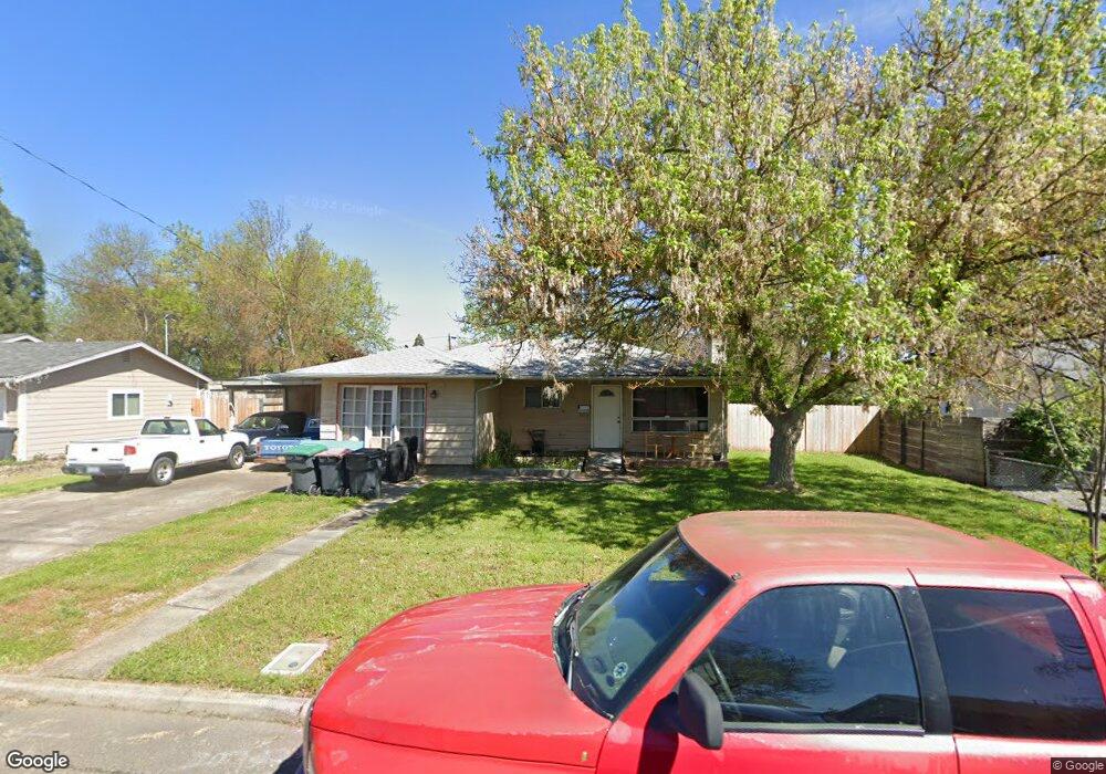
105 Kings Way Central Point, OR 97502
Estimated Value: $269,228 - $338,000
3
Beds
2
Baths
1,340
Sq Ft
$223/Sq Ft
Est. Value
About This Home
This home is located at 105 Kings Way, Central Point, OR 97502 and is currently estimated at $299,057, approximately $223 per square foot. 105 Kings Way is a home located in Jackson County with nearby schools including Jewett Elementary School, Scenic Middle School, and Crater High School.
Ownership History
Date
Name
Owned For
Owner Type
Purchase Details
Closed on
Sep 9, 2020
Sold by
Knight Robret William
Bought by
Knight Investment Properties Ii Llc
Current Estimated Value
Purchase Details
Closed on
Jan 22, 2018
Sold by
Knight Shirley L and Knight Rick David
Bought by
Robert W Knight And Shirley L Knight Revocabl and Knight
Purchase Details
Closed on
Mar 21, 2016
Sold by
Knight Investment Properties Ii Llc
Bought by
Delaney Sam N and Corwin Stephanie L
Home Financials for this Owner
Home Financials are based on the most recent Mortgage that was taken out on this home.
Original Mortgage
$147,150
Interest Rate
2.7%
Mortgage Type
New Conventional
Purchase Details
Closed on
Jul 30, 2014
Sold by
Knight Robert W and Knight Shirley L
Bought by
The Robert W Wright & Shirley L Knight R
Create a Home Valuation Report for This Property
The Home Valuation Report is an in-depth analysis detailing your home's value as well as a comparison with similar homes in the area
Home Values in the Area
Average Home Value in this Area
Purchase History
| Date | Buyer | Sale Price | Title Company |
|---|---|---|---|
| Knight Investment Properties Ii Llc | -- | None Available | |
| Robert W Knight And Shirley L Knight Revocabl | -- | None Listed On Document | |
| Delaney Sam N | $163,500 | First American | |
| The Robert W Wright & Shirley L Knight R | -- | None Available |
Source: Public Records
Mortgage History
| Date | Status | Borrower | Loan Amount |
|---|---|---|---|
| Previous Owner | Delaney Sam N | $147,150 |
Source: Public Records
Tax History Compared to Growth
Tax History
| Year | Tax Paid | Tax Assessment Tax Assessment Total Assessment is a certain percentage of the fair market value that is determined by local assessors to be the total taxable value of land and additions on the property. | Land | Improvement |
|---|---|---|---|---|
| 2025 | $2,655 | $159,670 | $67,520 | $92,150 |
| 2024 | $2,655 | $155,020 | $65,560 | $89,460 |
| 2023 | $2,569 | $150,510 | $63,660 | $86,850 |
| 2022 | $2,509 | $150,510 | $63,660 | $86,850 |
| 2021 | $2,438 | $146,130 | $61,810 | $84,320 |
| 2020 | $2,367 | $141,880 | $60,010 | $81,870 |
| 2019 | $2,308 | $133,740 | $56,560 | $77,180 |
| 2018 | $2,238 | $129,850 | $54,910 | $74,940 |
| 2017 | $2,182 | $129,850 | $54,910 | $74,940 |
| 2016 | $2,118 | $122,400 | $51,750 | $70,650 |
| 2015 | $2,029 | $122,400 | $51,750 | $70,650 |
| 2014 | $1,976 | $115,380 | $48,780 | $66,600 |
Source: Public Records
Map
Nearby Homes
- 1010 N 3rd St
- 55 Crater Ln
- 905 Comet Ave
- 342 Hazel St
- 920 N 10th St
- 741 Hazel St
- 431 N 5th St
- 4626 N Pacific Hwy
- 833 Hazel St
- 405 N 9th St
- 0 Boulder Ridge St
- 327 Brookhaven Dr
- 356 Marian Ave Unit 40
- 1167 Boulder Ridge St
- 4035 Rock Way
- 0 Peninger Rd
- 546 Laurel St
- 144 N 5th St
- 626 Griffin Oaks Dr
- 426 Bridge Creek Dr