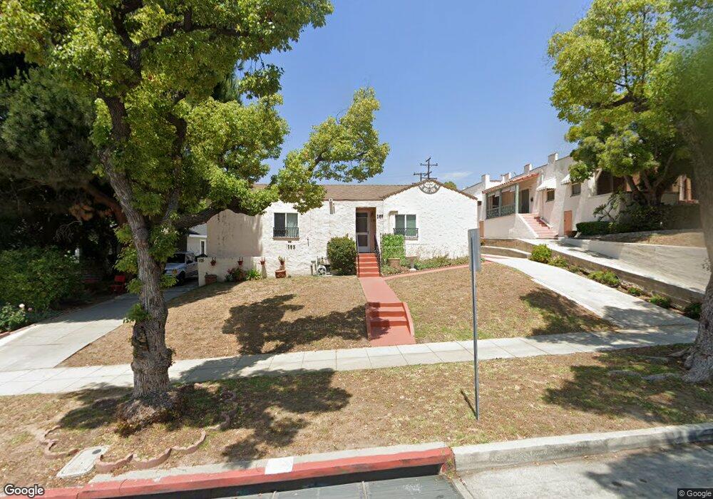
105 Lanewood Ave Alhambra, CA 91801
Emery Park NeighborhoodEstimated Value: $932,870 - $1,106,000
4
Beds
3
Baths
2,235
Sq Ft
$458/Sq Ft
Est. Value
About This Home
This home is located at 105 Lanewood Ave, Alhambra, CA 91801 and is currently estimated at $1,024,468, approximately $458 per square foot. 105 Lanewood Ave is a home located in Los Angeles County with nearby schools including Emery Park Elementary School, Alhambra High School, and Bell Tower School.
Ownership History
Date
Name
Owned For
Owner Type
Purchase Details
Closed on
May 24, 2010
Sold by
Wiggs Leticia
Bought by
Wiggs Leticia A and Wiggs Family Trust
Current Estimated Value
Purchase Details
Closed on
Sep 11, 2002
Sold by
Robinson Anthony J and Inter Vivos Trust Of Matilda M
Bought by
Wiggs Leticia L
Home Financials for this Owner
Home Financials are based on the most recent Mortgage that was taken out on this home.
Original Mortgage
$247,500
Interest Rate
5.78%
Create a Home Valuation Report for This Property
The Home Valuation Report is an in-depth analysis detailing your home's value as well as a comparison with similar homes in the area
Home Values in the Area
Average Home Value in this Area
Purchase History
| Date | Buyer | Sale Price | Title Company |
|---|---|---|---|
| Wiggs Leticia A | -- | None Available | |
| Wiggs Leticia L | $330,000 | American Title Co |
Source: Public Records
Mortgage History
| Date | Status | Borrower | Loan Amount |
|---|---|---|---|
| Previous Owner | Wiggs Leticia L | $247,500 | |
| Closed | Wiggs Leticia L | $82,500 |
Source: Public Records
Tax History
| Year | Tax Paid | Tax Assessment Tax Assessment Total Assessment is a certain percentage of the fair market value that is determined by local assessors to be the total taxable value of land and additions on the property. | Land | Improvement |
|---|---|---|---|---|
| 2025 | $6,320 | $477,932 | $334,556 | $143,376 |
| 2024 | $6,320 | $468,562 | $327,997 | $140,565 |
| 2023 | $6,338 | $459,375 | $321,566 | $137,809 |
| 2022 | $6,060 | $450,368 | $315,261 | $135,107 |
| 2021 | $5,992 | $441,538 | $309,080 | $132,458 |
| 2019 | $5,796 | $428,443 | $299,913 | $128,530 |
| 2018 | $5,735 | $420,043 | $294,033 | $126,010 |
| 2016 | $5,290 | $403,734 | $282,616 | $121,118 |
| 2015 | $5,213 | $397,670 | $278,371 | $119,299 |
| 2014 | $5,164 | $389,882 | $272,919 | $116,963 |
Source: Public Records
Map
Nearby Homes
- 3215 Sherwood Ave
- 101 Hampden Terrace
- 4206 Lowell Ave
- 143 Palatine Dr
- 182 Palatine Dr
- 216 Stockbridge Ave
- 10 N Huntington Dr
- 4303 Stillwell Ave
- 3823 Stockbridge Ave
- 4506 Maycrest Ave
- 3212 Poplar Blvd
- 319 Westmont Dr
- 4124 Barrett Rd
- 5301 Huntington Dr N
- 2070 Meridian Ave
- 5353 5355 Oakland St
- 5262 Remstoy Dr
- 601 Orange Grove Ave
- 2025 Maycrest Ave
- 5243 Huntington Dr N
- 109 Lanewood Ave
- 104 Westmont Dr
- 3136 Sherwood Ave
- 113 Lanewood Ave
- 3132 Sherwood Ave
- 89 Hampden Terrace
- 117 Lanewood Ave
- 108 Westmont Dr
- 3130 Sherwood Ave
- 85 Hampden Terrace
- 0 Alpha St
- 25 Westmont Dr
- 3124 Sherwood Ave
- 83 Hampden Terrace
- 3204 Sherwood Ave
- 3135 Sherwood Ave
- 3209 Sherwood Ave
- 111 Westmont Dr
- 3108 Sherwood Ave
- 3120 Sherwood Ave
Your Personal Tour Guide
Ask me questions while you tour the home.