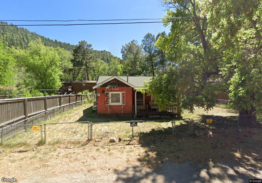
105 Robin Rd Ruidoso, NM 88345
Estimated Value: $177,407 - $547,000
--
Bed
--
Bath
1,120
Sq Ft
$288/Sq Ft
Est. Value
About This Home
This home is located at 105 Robin Rd, Ruidoso, NM 88345 and is currently estimated at $323,102, approximately $288 per square foot. 105 Robin Rd is a home with nearby schools including Sierra Vista Primary School, White Mountain Elementary School, and Ruidoso Middle School.
Ownership History
Date
Name
Owned For
Owner Type
Purchase Details
Closed on
May 3, 2010
Sold by
Martin Robert A
Bought by
Criter & Mali Llc
Current Estimated Value
Purchase Details
Closed on
May 28, 2004
Sold by
Innis Vicki L
Bought by
Martin Robert A
Home Financials for this Owner
Home Financials are based on the most recent Mortgage that was taken out on this home.
Original Mortgage
$27,000
Interest Rate
5.78%
Mortgage Type
Unknown
Create a Home Valuation Report for This Property
The Home Valuation Report is an in-depth analysis detailing your home's value as well as a comparison with similar homes in the area
Home Values in the Area
Average Home Value in this Area
Purchase History
| Date | Buyer | Sale Price | Title Company |
|---|---|---|---|
| Criter & Mali Llc | -- | None Available | |
| Martin Robert A | -- | None Available |
Source: Public Records
Mortgage History
| Date | Status | Borrower | Loan Amount |
|---|---|---|---|
| Previous Owner | Martin Robert A | $27,000 |
Source: Public Records
Tax History Compared to Growth
Tax History
| Year | Tax Paid | Tax Assessment Tax Assessment Total Assessment is a certain percentage of the fair market value that is determined by local assessors to be the total taxable value of land and additions on the property. | Land | Improvement |
|---|---|---|---|---|
| 2025 | $1,361 | $46,611 | $2,651 | $43,960 |
| 2024 | $1,361 | $45,254 | $2,574 | $42,680 |
| 2023 | $1,361 | $43,936 | $2,499 | $41,437 |
| 2022 | $1,289 | $42,656 | $2,426 | $40,230 |
| 2021 | $1,246 | $41,409 | $2,355 | $39,054 |
| 2020 | $1,221 | $40,202 | $2,286 | $37,916 |
| 2019 | $1,142 | $39,413 | $2,241 | $37,172 |
| 2018 | $1,102 | $38,265 | $2,176 | $36,089 |
| 2017 | $1,061 | $37,151 | $2,113 | $35,038 |
| 2015 | $1,032 | $36,072 | $2,051 | $34,021 |
| 2014 | $1,002 | $35,021 | $1,991 | $33,030 |
Source: Public Records
Map
Nearby Homes
- Lot B-1 Sudderth Dr
- 2926 Sudderth Dr
- 425 Sudderth Dr
- 201 Carrizo Canyon Rd
- 1208 Sudderth Dr
- 114 N Vine Rd
- 127 Carters Ln
- 222 Paradise Canyon Dr
- 129 Taos Trail
- 411 Carters Ln
- 109 Bradley Dr
- 102 Cochise Place
- 201 Bradley
- 257 Crown Dr
- 174 King Rd Unit 4302
- 174 King Rd Unit 4405
- 174 King Rd Unit 4105
- 111 Mountain Trail
- 305 Walton Cir
- 109 Hart Ave
- 103 Robin Rd
- 107 Robin Rd
- 109 Robin Rd
- 806 Sudderth Dr
- 806 Sudderth Dr
- 806 Sudderth Dr
- 900 Sudderth Dr
- 908 Sudderth Dr
- 910 Sudderth Dr
- 119 Robin Rd
- 122 Carrizo Canyon Rd
- 1101- 1101 Dr
- 125 Robin Rd
- 129 Robin Rd
- 124 Carrizo Canyon Rd
- 921 Sudderth Dr
- 751 Sudderth Dr
- - Sudderth Dr
- 000 Sudderth Dr
- 15001508 Sudderth Dr