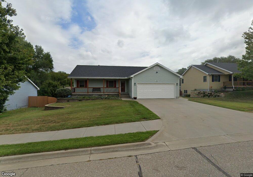
105 Snyder Dr Saint George, KS 66535
Estimated Value: $264,000 - $297,000
3
Beds
2
Baths
1,296
Sq Ft
$213/Sq Ft
Est. Value
About This Home
This home is located at 105 Snyder Dr, Saint George, KS 66535 and is currently estimated at $275,503, approximately $212 per square foot. 105 Snyder Dr is a home located in Pottawatomie County with nearby schools including Rock Creek Junior/Senior High School.
Ownership History
Date
Name
Owned For
Owner Type
Purchase Details
Closed on
May 17, 2006
Sold by
D & R Construction Inc
Bought by
Mitchell Kevin L
Current Estimated Value
Home Financials for this Owner
Home Financials are based on the most recent Mortgage that was taken out on this home.
Original Mortgage
$164,803
Outstanding Balance
$95,992
Interest Rate
6.5%
Estimated Equity
$179,511
Create a Home Valuation Report for This Property
The Home Valuation Report is an in-depth analysis detailing your home's value as well as a comparison with similar homes in the area
Home Values in the Area
Average Home Value in this Area
Purchase History
| Date | Buyer | Sale Price | Title Company |
|---|---|---|---|
| Mitchell Kevin L | -- | None Available |
Source: Public Records
Mortgage History
| Date | Status | Borrower | Loan Amount |
|---|---|---|---|
| Open | Mitchell Kevin L | $164,803 |
Source: Public Records
Tax History Compared to Growth
Tax History
| Year | Tax Paid | Tax Assessment Tax Assessment Total Assessment is a certain percentage of the fair market value that is determined by local assessors to be the total taxable value of land and additions on the property. | Land | Improvement |
|---|---|---|---|---|
| 2025 | $698 | $28,543 | $2,011 | $26,532 |
| 2024 | $51 | $28,370 | $2,011 | $26,359 |
| 2023 | $5,032 | $26,934 | $2,059 | $24,875 |
| 2022 | $4,418 | $23,923 | $2,080 | $21,843 |
| 2021 | $4,418 | $22,413 | $2,133 | $20,280 |
| 2020 | $4,418 | $22,151 | $2,141 | $20,010 |
| 2019 | $4,313 | $21,654 | $1,903 | $19,751 |
| 2018 | $4,287 | $21,608 | $2,011 | $19,597 |
| 2017 | $4,070 | $21,874 | $1,328 | $20,546 |
| 2016 | $3,982 | $21,528 | $1,193 | $20,335 |
| 2015 | -- | $20,987 | $1,135 | $19,852 |
| 2014 | -- | $20,240 | $1,212 | $19,028 |
Source: Public Records
Map
Nearby Homes
- 306 Snyder Dr
- 13140 Anthony Dr
- 107 Quail Ct
- 507 Shady Oak Dr
- 402 1st St
- 00000 Countryside Ln Unit Lot 6
- 00000 Countryside Ln Unit Lot 20
- 00000 Countryside Ln Unit Lot 7
- 00000 Countryside Ln Unit Lot 16
- 00000 Countryside Ln Unit Lot 14
- 00000 Countryside Ln Unit Lot 9
- 00000 Countryside Ln Unit Lot 10
- 00000 Countryside Ln Unit Lot 24
- 00000 Countryside Ln Unit Lot 19
- 00000 Countryside Ln Unit Lot 4
- 00000 Countryside Ln Unit Lot 17
- 00000 Countryside Ln Unit Lot 22
- 00000 Countryside Ln Unit Lot 3
- 00000 Countryside Ln Unit Lot 11
- 00000 Countryside Ln Unit Lot 8
- 103 Snyder Dr
- 107 Snyder Dr
- 109 Snyder Dr
- 104 Snyder Dr
- 105 Wildcat Way
- 103 Wildcat Way
- 701 Snyder Cir
- 101 Snyder Dr
- 101 Wildcat Way
- 109 Wildcat Way
- 111 Wildcat Way
- 111 Snyder Dr
- 113 Wildcat Way
- 103 Lockett Ln
- 100 Lockett Ln
- 115 Wildcat Way
- 703 Snyder Cir
- 113 Snyder Dr
- 102 Lockett Ln
- 117 Wildcat Way