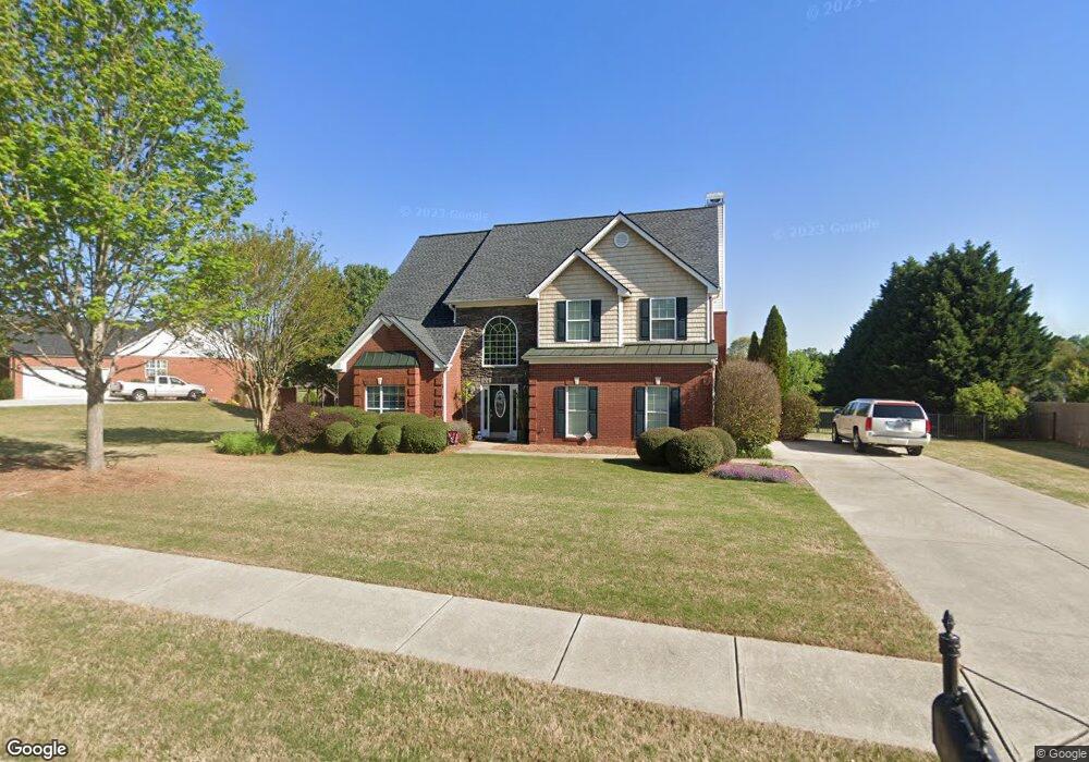
1050 Sunstone Dr Unit 8C Bogart, GA 30622
Estimated Value: $568,164 - $613,000
4
Beds
3
Baths
2,796
Sq Ft
$210/Sq Ft
Est. Value
About This Home
This home is located at 1050 Sunstone Dr Unit 8C, Bogart, GA 30622 and is currently estimated at $587,291, approximately $210 per square foot. 1050 Sunstone Dr Unit 8C is a home located in Oconee County with nearby schools including Rocky Branch Elementary School, Malcom Bridge Middle School, and North Oconee High School.
Ownership History
Date
Name
Owned For
Owner Type
Purchase Details
Closed on
Nov 16, 2005
Sold by
Star Home Builders Inc
Bought by
Jackson Ransom J and Jackson Laurie M
Current Estimated Value
Home Financials for this Owner
Home Financials are based on the most recent Mortgage that was taken out on this home.
Original Mortgage
$191,900
Outstanding Balance
$105,145
Interest Rate
6.04%
Mortgage Type
New Conventional
Estimated Equity
$482,146
Create a Home Valuation Report for This Property
The Home Valuation Report is an in-depth analysis detailing your home's value as well as a comparison with similar homes in the area
Home Values in the Area
Average Home Value in this Area
Purchase History
| Date | Buyer | Sale Price | Title Company |
|---|---|---|---|
| Jackson Ransom J | $239,900 | -- |
Source: Public Records
Mortgage History
| Date | Status | Borrower | Loan Amount |
|---|---|---|---|
| Open | Jackson Ransom J | $191,900 | |
| Closed | Jackson Ransom J | $48,000 |
Source: Public Records
Tax History Compared to Growth
Tax History
| Year | Tax Paid | Tax Assessment Tax Assessment Total Assessment is a certain percentage of the fair market value that is determined by local assessors to be the total taxable value of land and additions on the property. | Land | Improvement |
|---|---|---|---|---|
| 2024 | $2,390 | $185,598 | $36,000 | $149,598 |
| 2023 | $2,390 | $170,047 | $30,000 | $140,047 |
| 2022 | $2,733 | $146,923 | $26,000 | $120,923 |
| 2021 | $2,900 | $125,503 | $16,000 | $109,503 |
| 2020 | $2,731 | $118,024 | $16,000 | $102,024 |
| 2019 | $2,495 | $107,844 | $16,000 | $91,844 |
| 2018 | $2,377 | $100,606 | $16,000 | $84,606 |
| 2017 | $2,355 | $99,701 | $16,000 | $83,701 |
| 2016 | $2,206 | $93,415 | $15,200 | $78,215 |
| 2015 | $2,018 | $85,297 | $15,200 | $70,097 |
| 2014 | $2,099 | $86,724 | $16,000 | $70,724 |
| 2013 | -- | $83,182 | $16,000 | $67,182 |
Source: Public Records
Map
Nearby Homes
- 1090 Ruby Way
- 1181 Pete Dickens Rd
- 4100 Monroe Hwy
- 4400 Monroe Hwy Unit PARCEL 1-7
- 1250 Pete Dickens Rd
- 3240 Monroe Hwy
- 1190 Cobblestone Ln
- 1120 Liberty Ln
- 1101 Derby Ln
- 1101 Derby Ln
- 1327 Eisenhower Ave
- 1145 Summerfield Ln
- 1180 Summerfield Ln
- 00 Ruth Jackson Rd
- 0 Ruth Jackson Rd Unit 10582108
- 3041 Monroe Hwy
- 1640 Madison Ct
- 1220 Day Dr
- 1279 Day Dr
- 1050 Sunstone Dr
- 1070 Sunstone Dr Unit 9C
- 1070 Sunstone Dr
- 1011 Solitaire Ct Unit 7C
- 1011 Solitaire Ct
- 0 Sunstone Dr Unit 8219972
- 0 Sunstone Dr Unit 8053585
- 0 Sunstone Dr
- 1051 Sunstone Dr Unit 4A
- 1051 Sunstone Dr
- 1041 Sunstone Dr Unit 3A
- 1041 Sunstone Dr
- 1031 Solitaire Ct Unit 6C
- 1031 Solitaire Ct
- 1031 Sunstone Dr Unit 2A
- 1031 Sunstone Dr
- 1021 Talus St Unit 5A
- 1021 Talus St
- 0 Solitaire Ct Unit 7487437
- 0 Solitaire Ct Unit 3221851