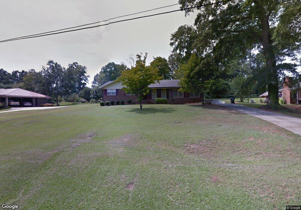
1050 Thomas St Greensboro, GA 30642
Estimated Value: $266,000 - $416,000
3
Beds
2
Baths
2,132
Sq Ft
$148/Sq Ft
Est. Value
About This Home
This home is located at 1050 Thomas St, Greensboro, GA 30642 and is currently estimated at $316,138, approximately $148 per square foot. 1050 Thomas St is a home located in Greene County with nearby schools including Greene County High School.
Ownership History
Date
Name
Owned For
Owner Type
Purchase Details
Closed on
Dec 6, 2004
Sold by
Raber Gloria Ann
Bought by
Antone Ava Nicole
Current Estimated Value
Purchase Details
Closed on
Dec 1, 2004
Sold by
Raber Gloria Ann
Bought by
Antone Ava Nicole
Purchase Details
Closed on
Nov 12, 1991
Sold by
Sellers Ray
Bought by
Raber Gloria Ann
Purchase Details
Closed on
Jan 1, 1981
Sold by
Sellers Ray and Sellers Cindy
Bought by
Sellers Ray
Purchase Details
Closed on
Jan 1, 1979
Sold by
Daughtry Ronald F
Bought by
Sellers Ray and Sellers Cindy
Purchase Details
Closed on
Jan 1, 1969
Bought by
Daughtry Ronald F
Create a Home Valuation Report for This Property
The Home Valuation Report is an in-depth analysis detailing your home's value as well as a comparison with similar homes in the area
Home Values in the Area
Average Home Value in this Area
Purchase History
| Date | Buyer | Sale Price | Title Company |
|---|---|---|---|
| Antone Ava Nicole | $122,000 | -- | |
| Antone Ava Nicole | $122,000 | -- | |
| Raber Gloria Ann | $85,000 | -- | |
| Sellers Ray | -- | -- | |
| Sellers Ray | $40,000 | -- | |
| Daughtry Ronald F | -- | -- |
Source: Public Records
Tax History Compared to Growth
Tax History
| Year | Tax Paid | Tax Assessment Tax Assessment Total Assessment is a certain percentage of the fair market value that is determined by local assessors to be the total taxable value of land and additions on the property. | Land | Improvement |
|---|---|---|---|---|
| 2024 | $1,592 | $98,920 | $24,000 | $74,920 |
| 2023 | $791 | $92,680 | $24,000 | $68,680 |
| 2022 | $1,098 | $86,000 | $24,000 | $62,000 |
| 2021 | $1,155 | $72,760 | $18,000 | $54,760 |
| 2020 | $1,029 | $45,160 | $17,000 | $28,160 |
| 2019 | $1,071 | $45,160 | $17,000 | $28,160 |
| 2018 | $1,049 | $45,160 | $17,000 | $28,160 |
| 2017 | $989 | $45,195 | $17,000 | $28,195 |
| 2016 | $1,010 | $46,253 | $17,000 | $29,253 |
| 2015 | $969 | $46,252 | $17,000 | $29,253 |
| 2014 | $954 | $44,357 | $17,000 | $27,357 |
Source: Public Records
Map
Nearby Homes
- 301 N East St
- 1531 E Broad St
- 0 Railroad St Unit 218854
- 0 Railroad St Unit 10578007
- 0 Railroad St Unit 531919
- 15 South St Unit Siloam Road
- 1020 Horton Dr
- 504 Martin Luther King Junior Dr
- 1060 Twin Pines Cir
- 0 Canaan St
- 314 W South St
- LOT 1 Penfield
- 109 Reynolds Dr
- 805 S West St
- 105 Wilson St
- 0 Maple Cir
- 1061 Grimes St
- 1131 Planing Mill Rd
- 1141 Planing Mill Rd
- 1141 Armour Cir
- 1030 Thomas St
- 1060 Thomas St
- 1070 Thomas Dr
- 1070 Thomas St
- 1021 Thomas St
- 1280 E Broad St
- 32.43 AC Us Highway 278 Unit 32.43 AC
- 5881 Us Highway 278
- E E Broad St Unit 10, 11
- E E Broad St
- 320 E Greene St
- 1240 E Broad St
- 318 E Greene St
- 102 Pinecrest Dr
- 1360 E Broad St
- 111 Pinecrest St
- 1221 E Broad St
- 1080 Phelps Rd
- 312 E Greene St
- 104 Pinecrest St