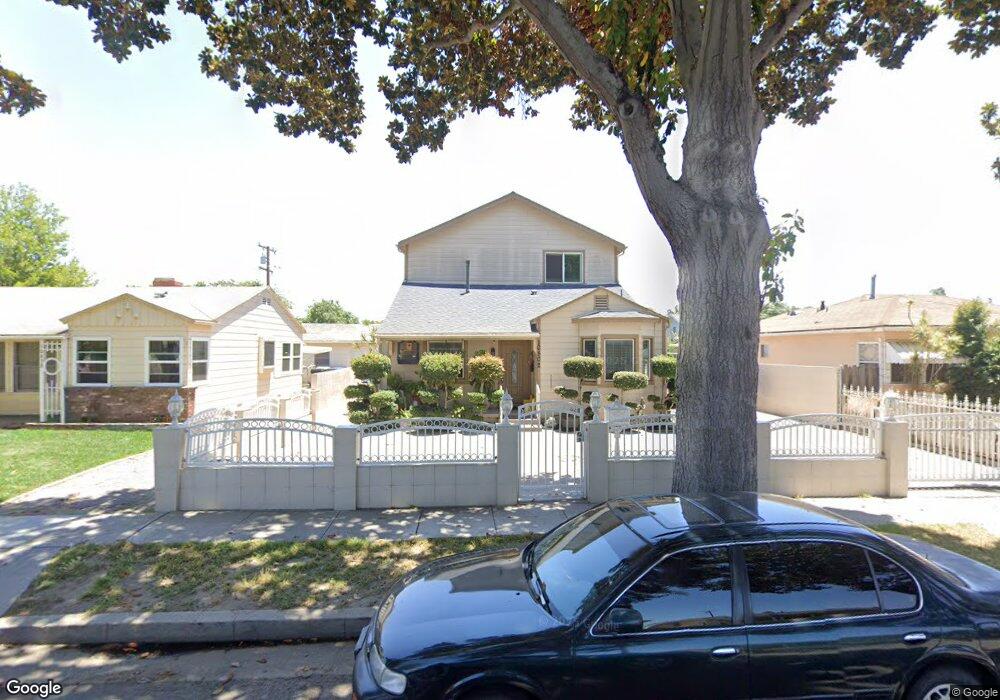
10502 Mcnerney Ave South Gate, CA 90280
Estimated Value: $775,000 - $856,000
3
Beds
2
Baths
2,190
Sq Ft
$372/Sq Ft
Est. Value
About This Home
This home is located at 10502 Mcnerney Ave, South Gate, CA 90280 and is currently estimated at $813,764, approximately $371 per square foot. 10502 Mcnerney Ave is a home located in Los Angeles County with nearby schools including Bryson Avenue Elementary School, South Gate Middle School, and Southeast Middle School.
Ownership History
Date
Name
Owned For
Owner Type
Purchase Details
Closed on
Oct 9, 2014
Sold by
Perez Virginia P
Bought by
Ih4 Property West Lp
Current Estimated Value
Purchase Details
Closed on
Sep 17, 2003
Sold by
Perez Virginia P
Bought by
Perez Virginia P
Home Financials for this Owner
Home Financials are based on the most recent Mortgage that was taken out on this home.
Original Mortgage
$100,000
Interest Rate
4.8%
Mortgage Type
Credit Line Revolving
Purchase Details
Closed on
Sep 14, 2001
Sold by
Perez Virginia P and Martinez Maria Cristina Mendiolea
Bought by
Perez Virginia P
Home Financials for this Owner
Home Financials are based on the most recent Mortgage that was taken out on this home.
Original Mortgage
$95,000
Interest Rate
6.99%
Create a Home Valuation Report for This Property
The Home Valuation Report is an in-depth analysis detailing your home's value as well as a comparison with similar homes in the area
Home Values in the Area
Average Home Value in this Area
Purchase History
| Date | Buyer | Sale Price | Title Company |
|---|---|---|---|
| Ih4 Property West Lp | $337,600 | Fidelity National Title Co | |
| Perez Virginia P | -- | Gateway Title Company | |
| Perez Virginia P | -- | First American Title Ins Co |
Source: Public Records
Mortgage History
| Date | Status | Borrower | Loan Amount |
|---|---|---|---|
| Previous Owner | Perez Virginia P | $100,000 | |
| Previous Owner | Perez Virginia P | $95,000 |
Source: Public Records
Tax History
| Year | Tax Paid | Tax Assessment Tax Assessment Total Assessment is a certain percentage of the fair market value that is determined by local assessors to be the total taxable value of land and additions on the property. | Land | Improvement |
|---|---|---|---|---|
| 2025 | $7,565 | $584,929 | $348,173 | $236,756 |
| 2024 | $7,565 | $573,461 | $341,347 | $232,114 |
| 2023 | $7,436 | $562,217 | $334,654 | $227,563 |
| 2022 | $7,082 | $551,194 | $328,093 | $223,101 |
| 2021 | $6,996 | $540,387 | $321,660 | $218,727 |
| 2019 | $6,344 | $486,979 | $301,669 | $185,310 |
| 2018 | $6,165 | $477,431 | $295,754 | $181,677 |
| 2016 | $5,886 | $458,893 | $284,270 | $174,623 |
| 2015 | $5,793 | $452,000 | $280,000 | $172,000 |
| 2014 | $3,652 | $263,466 | $54,717 | $208,749 |
Source: Public Records
Map
Nearby Homes
- 4087 Abbott Rd
- 10845 Otis St
- 10414 Dorothy Ave
- 10930 Otis St
- 3813 Lyndora St
- 10970 Ruth St
- 11022 Benwell Dr
- 10406 San Carlos Ave
- 10525 Washington Ave
- 10309 Washington Ave
- 9718 Otis St
- 10231 San Carlos Ave
- 3568 Brenton Ave
- 9643 Mallison Ave
- 9710 San Miguel Ave
- 9616 Bowman Ave
- 10249 California Ave
- 9723 San Juan Ave
- 9525 Bowman Ave
- 11267 Sampson Ave
- 10438 Mcnerney Ave
- 10508 Mcnerney Ave
- 10514 Mcnerney Ave
- 10432 Mcnerney Ave
- 10503 Bowman Ave
- 10439 Bowman Ave
- 10509 Bowman Ave
- 10426 Mcnerney Ave
- 10520 Mcnerney Ave
- 10433 Bowman Ave
- 10515 Bowman Ave
- 10443 Mcnerney Ave
- 10505 Mcnerney Ave
- 10439 Mcnerney Ave
- 10509 Mcnerney Ave
- 10427 Bowman Ave
- 10420 Mcnerney Ave
- 10526 Mcnerney Ave
- 10521 Bowman Ave
- 10431 Mcnerney Ave
Your Personal Tour Guide
Ask me questions while you tour the home.