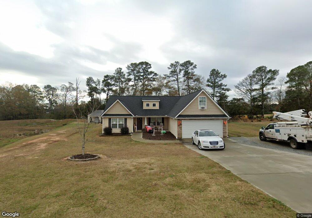
1051 Stoneham Cir Anderson, SC 29626
Estimated Value: $297,810 - $318,000
3
Beds
2
Baths
1,750
Sq Ft
$176/Sq Ft
Est. Value
About This Home
This home is located at 1051 Stoneham Cir, Anderson, SC 29626 and is currently estimated at $307,703, approximately $175 per square foot. 1051 Stoneham Cir is a home located in Anderson County with nearby schools including McLees Elementary School, Robert Anderson Middle School, and Westside High School.
Ownership History
Date
Name
Owned For
Owner Type
Purchase Details
Closed on
Feb 28, 2022
Sold by
Moore Brittany N
Bought by
Moore Brittany N and Moore Tommy Joe
Current Estimated Value
Home Financials for this Owner
Home Financials are based on the most recent Mortgage that was taken out on this home.
Original Mortgage
$135,885
Outstanding Balance
$107,004
Interest Rate
3.15%
Mortgage Type
New Conventional
Estimated Equity
$200,699
Purchase Details
Closed on
Feb 20, 2015
Sold by
Ambria Properties Llc
Bought by
Miceli Brittany N
Home Financials for this Owner
Home Financials are based on the most recent Mortgage that was taken out on this home.
Original Mortgage
$151,989
Interest Rate
3.81%
Mortgage Type
New Conventional
Purchase Details
Closed on
Oct 20, 2014
Sold by
Wakefield Subdivision Llc
Bought by
Ambria Properties Llc
Purchase Details
Closed on
Aug 31, 2012
Sold by
Brashier T Walter
Bought by
Wakefield Subdivision Llc
Create a Home Valuation Report for This Property
The Home Valuation Report is an in-depth analysis detailing your home's value as well as a comparison with similar homes in the area
Home Values in the Area
Average Home Value in this Area
Purchase History
| Date | Buyer | Sale Price | Title Company |
|---|---|---|---|
| Moore Brittany N | -- | Holler Law Firm Llc | |
| Miceli Brittany N | $148,950 | -- | |
| Ambria Properties Llc | $18,000 | -- | |
| Wakefield Subdivision Llc | -- | -- |
Source: Public Records
Mortgage History
| Date | Status | Borrower | Loan Amount |
|---|---|---|---|
| Open | Moore Brittany N | $135,885 | |
| Previous Owner | Miceli Brittany N | $151,989 |
Source: Public Records
Tax History
| Year | Tax Paid | Tax Assessment Tax Assessment Total Assessment is a certain percentage of the fair market value that is determined by local assessors to be the total taxable value of land and additions on the property. | Land | Improvement |
|---|---|---|---|---|
| 2024 | $898 | $7,720 | $1,000 | $6,720 |
| 2023 | $903 | $7,720 | $1,000 | $6,720 |
| 2022 | $872 | $7,720 | $1,000 | $6,720 |
| 2021 | $780 | $6,210 | $800 | $5,410 |
| 2020 | $772 | $6,210 | $800 | $5,410 |
| 2019 | $772 | $6,210 | $800 | $5,410 |
| 2018 | $785 | $6,210 | $800 | $5,410 |
| 2017 | -- | $6,210 | $800 | $5,410 |
| 2016 | $2,826 | $1,080 | $1,080 | $0 |
| 2015 | $338 | $1,320 | $1,320 | $0 |
| 2014 | $56 | $1,320 | $1,320 | $0 |
Source: Public Records
Map
Nearby Homes
- 1058 Stoneham Cir
- 1017 Stoneham Cir
- 1809 Busby Rd
- 202 Highway 187 S
- 401 New Hope Rd
- 144 Old Asbury Rd
- 1518 Old Trail Dr
- 2114 Karen Ln
- 00 Old Trail Dr
- 217 Cherry Seed Rd
- 206 Westwind Harbour Dr
- 4123 Old Portman Rd
- 348 Peninsula Dr
- 102 Saint Clair Rd
- 201 Knollwood Dr
- 114 Meadowood Dr
- 121 Flynn Dr
- 101 Springview Dr
- 106 Garrett Maxwell Rd
- 117 Flynn Dr
- 1051 Stoneham Cir Unit Lot 27
- 1049 Stoneham Cir
- 1047 Stoneham Cir Unit Lot 25
- 1047 Stoneham Cir
- 1055 Stoneham Cir
- 1046 Stoneham Cir
- 1048 Stoneham Cir
- 1045 Stoneham Cir Unit Lot 24
- 1045 Stoneham Cir
- 101 Groveland Ct Unit Lot 30
- 101 Groveland Ct
- 1050 Stoneham Cir
- 103 Groveland Ct Unit Lot 31
- 103 Groveland Ct
- 1038 Stoneham Cir
- 1052 Stoneham Cir
- 1036 Stoneham Cir
- 1043 Stoneham Cir
- 105 Groveland Ct Unit lot 32
- 105 Groveland Ct
Your Personal Tour Guide
Ask me questions while you tour the home.