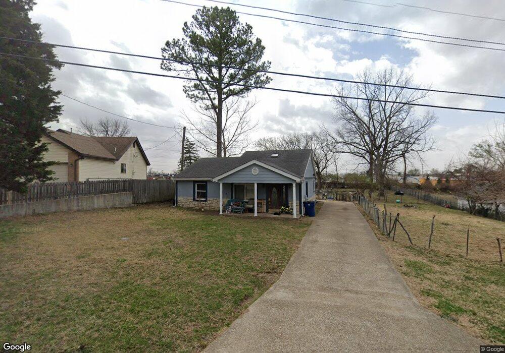
10516 Locust Ave Saint Louis, MO 63114
Estimated Value: $97,000 - $137,000
2
Beds
1
Bath
843
Sq Ft
$144/Sq Ft
Est. Value
About This Home
This home is located at 10516 Locust Ave, Saint Louis, MO 63114 and is currently estimated at $121,242, approximately $143 per square foot. 10516 Locust Ave is a home located in St. Louis County with nearby schools including Buder Elementary School, Hoech Middle School, and Ritenour Senior High School.
Ownership History
Date
Name
Owned For
Owner Type
Purchase Details
Closed on
Mar 25, 2021
Sold by
Spoto Salvatore and Spoto Myra D
Bought by
Khalfadir Elkbir
Current Estimated Value
Purchase Details
Closed on
May 2, 2011
Sold by
Phelan Richard F
Bought by
Spoto Salvatore
Purchase Details
Closed on
Dec 12, 1997
Sold by
Phelan James J and Phelan Richard F
Bought by
Phelan James J and Phelan Richard F
Purchase Details
Closed on
Sep 6, 1997
Sold by
Phelan Marie M and Phelan Florence
Bought by
Phelan James J and Phelan Richard F
Create a Home Valuation Report for This Property
The Home Valuation Report is an in-depth analysis detailing your home's value as well as a comparison with similar homes in the area
Home Values in the Area
Average Home Value in this Area
Purchase History
| Date | Buyer | Sale Price | Title Company |
|---|---|---|---|
| Khalfadir Elkbir | $30,000 | Title Partners Agency Llc | |
| Spoto Salvatore | $26,000 | None Available | |
| Phelan James J | -- | -- | |
| Phelan James J | -- | -- |
Source: Public Records
Tax History Compared to Growth
Tax History
| Year | Tax Paid | Tax Assessment Tax Assessment Total Assessment is a certain percentage of the fair market value that is determined by local assessors to be the total taxable value of land and additions on the property. | Land | Improvement |
|---|---|---|---|---|
| 2025 | $1,769 | $24,320 | $7,660 | $16,660 |
| 2024 | $1,769 | $21,550 | $4,600 | $16,950 |
| 2023 | $1,736 | $21,550 | $4,600 | $16,950 |
| 2022 | $1,265 | $13,810 | $3,570 | $10,240 |
| 2021 | $1,261 | $13,810 | $3,570 | $10,240 |
| 2020 | $1,085 | $11,020 | $4,790 | $6,230 |
| 2019 | $1,072 | $11,020 | $4,790 | $6,230 |
| 2018 | $1,274 | $11,760 | $4,390 | $7,370 |
| 2017 | $1,213 | $11,760 | $4,390 | $7,370 |
| 2016 | $619 | $5,660 | $3,610 | $2,050 |
| 2015 | $622 | $5,660 | $3,610 | $2,050 |
| 2014 | $538 | $4,940 | $3,190 | $1,750 |
Source: Public Records
Map
Nearby Homes
- 1841 N Warson Rd
- 1735 O Connell Ave
- 10726 Niblic Dr
- 10301 Niblic Dr
- 10110 Lackland Rd
- 10490 Canter Way
- 2255 N Warson Rd
- 10222 Driver Ave
- 10627 Canter Way
- 2412 Silkwood Dr
- 2450 Fowler Ave
- 2430 Prouhet Ave
- 9913 Zykan Ct
- 9906 Zykan Ct
- 2300 Ruckert Ave
- 2454 Prouhet Ave
- 10111 Niblic Dr
- 10107 Niblic Dr
- 9833 Zykan Dr
- 9833 Eastbrook Dr
- 10514 Locust Ave
- 10540 Locust Ave
- 10510 Locust Ave
- 10519 Locust Ave
- 10517 Locust Ave
- 10537 Locust Ave
- 10515 Locust Ave
- 10544 Locust Ave
- 1751 Ashby Rd
- 10541 Locust Ave
- 10511 Locust Ave
- 10548 Locust Ave
- 10538 Oak Ave
- 10540 Oak Ave
- 10530 Oak Ave
- 1821 Ashby Rd
- 10512 Oak Ave
- 1910 Fowler Ave
- 1812 Ashby Rd
- 10550 Oak Ave