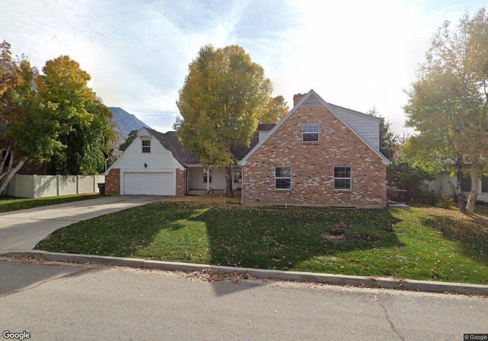
1054 Dover Dr Provo, UT 84604
Rock Canyon NeighborhoodEstimated Value: $844,035 - $1,126,000
5
Beds
4
Baths
3,331
Sq Ft
$289/Sq Ft
Est. Value
About This Home
This home is located at 1054 Dover Dr, Provo, UT 84604 and is currently estimated at $964,259, approximately $289 per square foot. 1054 Dover Dr is a home located in Utah County with nearby schools including Edgemont School, Centennial Middle School, and Timpview High School.
Ownership History
Date
Name
Owned For
Owner Type
Purchase Details
Closed on
Jul 1, 2021
Sold by
Devin Killpack
Bought by
Killpack Family Revocable Trust and Killpack
Current Estimated Value
Purchase Details
Closed on
Jun 30, 2021
Sold by
Killpack C Devin
Bought by
Killpack Family Revocable Trust and Killpack
Purchase Details
Closed on
Sep 11, 2020
Sold by
Allman Curt M and Featherstone Anna
Bought by
Allman Monte H
Home Financials for this Owner
Home Financials are based on the most recent Mortgage that was taken out on this home.
Original Mortgage
$114,000
Interest Rate
2.8%
Mortgage Type
Credit Line Revolving
Purchase Details
Closed on
Aug 22, 2016
Sold by
Bown Stephen Edward and The Bown Family Trust
Bought by
Killpack Devin C
Home Financials for this Owner
Home Financials are based on the most recent Mortgage that was taken out on this home.
Original Mortgage
$417,000
Interest Rate
3.45%
Mortgage Type
New Conventional
Purchase Details
Closed on
Nov 14, 1997
Sold by
Bown Delos E
Bought by
Bown Delos E
Create a Home Valuation Report for This Property
The Home Valuation Report is an in-depth analysis detailing your home's value as well as a comparison with similar homes in the area
Home Values in the Area
Average Home Value in this Area
Purchase History
We collect this data history from publicly available records. To have your information removed, we recommend requesting removal directly through your county’s website.
| Date | Buyer | Sale Price | Title Company |
|---|---|---|---|
| Killpack Family Revocable Trust | -- | None Listed On Document | |
| Killpack Family Revocable Trust | -- | None Listed On Document | |
| Killpack Christopher Devin | -- | None Available | |
| Allman Monte H | -- | Bartlett Title Ins Agcy Inc | |
| Killpack Devin C | -- | Inwest Title | |
| Bown Delos E | -- | -- |
Source: Public Records
Mortgage History
We collect this data history from publicly available records. To have your information removed, we recommend requesting removal directly through your county’s website.
| Date | Status | Borrower | Loan Amount |
|---|---|---|---|
| Previous Owner | Allman Monte H | $114,000 | |
| Previous Owner | Killpack Devin C | $417,000 |
Source: Public Records
Tax History
| Year | Tax Paid | Tax Assessment Tax Assessment Total Assessment is a certain percentage of the fair market value that is determined by local assessors to be the total taxable value of land and additions on the property. | Land | Improvement |
|---|---|---|---|---|
| 2025 | $4,250 | $380,600 | -- | -- |
| 2024 | $4,250 | $418,385 | $0 | $0 |
| 2023 | $4,088 | $396,660 | $0 | $0 |
| 2022 | $3,819 | $373,725 | $0 | $0 |
| 2021 | $3,035 | $518,000 | $187,000 | $331,000 |
| 2020 | $3,045 | $487,100 | $162,600 | $324,500 |
| 2019 | $2,928 | $487,100 | $162,600 | $324,500 |
| 2018 | $2,865 | $483,400 | $158,900 | $324,500 |
| 2017 | $2,456 | $227,700 | $0 | $0 |
| 2016 | $2,467 | $213,180 | $0 | $0 |
| 2015 | $2,172 | $189,750 | $0 | $0 |
| 2014 | $1,871 | $170,390 | $0 | $0 |
Source: Public Records
Map
Nearby Homes
- 4150 Dover Ln
- 4077 Devonshire Cir
- 4299 Ivy Ln
- 4309 N Ivy Ln
- 4282 Churchill Dr
- 4277 N Imperial Way Unit 347
- 4093 Imperial Way
- 3702 N 920 E
- 596 E 4190 N Unit 5
- 3813 Foothill Dr
- 4122 Imperial Way
- 3675 Littlerock Ln
- 4282 Mile High Dr
- 4537 Mile High Dr
- 4606 Brookshire Cir
- 4612 N Bristol Cir
- 4640 Brookshire Cir
- 1085 Windsor Dr
- 4536 N 475 E
- 4662 Brookshire Cir
Your Personal Tour Guide
Ask me questions while you tour the home.