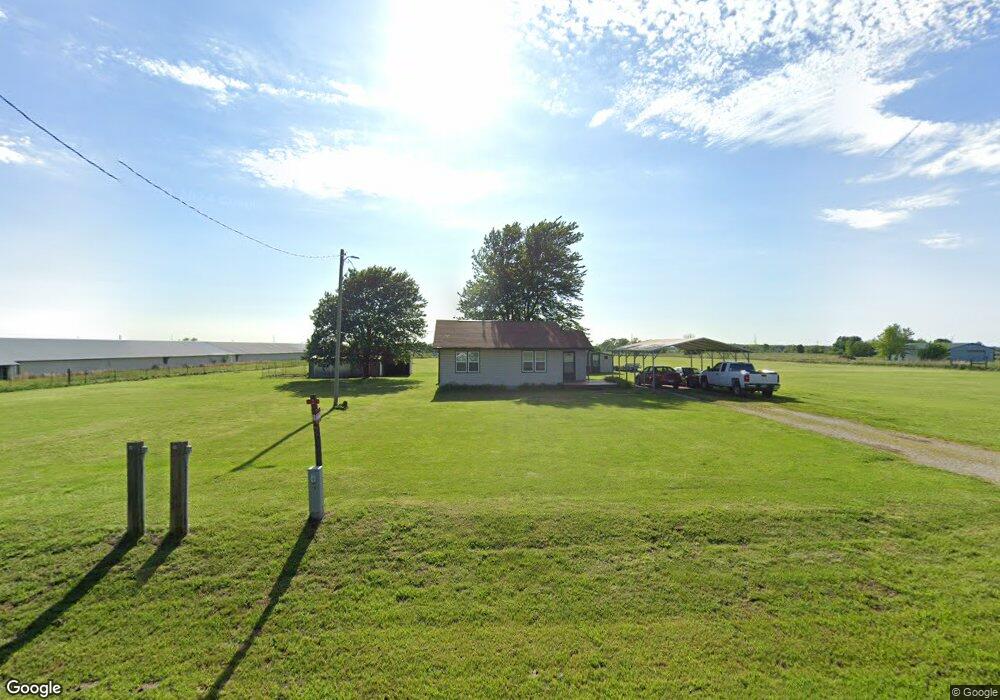
10541 Wpa Rd Gentry, AR 72734
Estimated Value: $153,601 - $435,000
Studio
--
Bath
992
Sq Ft
$281/Sq Ft
Est. Value
About This Home
This home is located at 10541 Wpa Rd, Gentry, AR 72734 and is currently estimated at $278,650, approximately $280 per square foot. 10541 Wpa Rd is a home with nearby schools including Gentry Intermediate School, Gentry Primary School, and Gentry Middle School.
Ownership History
Date
Name
Owned For
Owner Type
Purchase Details
Closed on
May 9, 2024
Sold by
Flynn Thomas Keith and Flynn Inge
Bought by
Flynn Michael
Current Estimated Value
Purchase Details
Closed on
Oct 24, 1994
Bought by
Flynn
Purchase Details
Closed on
Dec 20, 1993
Bought by
Winters
Purchase Details
Closed on
Jun 4, 1986
Bought by
Winters
Purchase Details
Closed on
Sep 17, 1980
Bought by
Winters
Create a Home Valuation Report for This Property
The Home Valuation Report is an in-depth analysis detailing your home's value as well as a comparison with similar homes in the area
Purchase History
| Date | Buyer | Sale Price | Title Company |
|---|---|---|---|
| Flynn Michael | -- | None Listed On Document | |
| Flynn | -- | -- | |
| Winters | -- | -- | |
| Winters | -- | -- | |
| Winters | $13,000 | -- |
Source: Public Records
Tax History
| Year | Tax Paid | Tax Assessment Tax Assessment Total Assessment is a certain percentage of the fair market value that is determined by local assessors to be the total taxable value of land and additions on the property. | Land | Improvement |
|---|---|---|---|---|
| 2025 | $612 | $23,284 | $5,600 | $17,684 |
| 2024 | $570 | $23,284 | $5,600 | $17,684 |
| 2023 | $752 | $20,340 | $7,000 | $13,340 |
| 2022 | $390 | $20,340 | $7,000 | $13,340 |
| 2021 | $354 | $20,340 | $7,000 | $13,340 |
| 2020 | $320 | $13,080 | $4,300 | $8,780 |
| 2019 | $320 | $13,080 | $4,300 | $8,780 |
| 2018 | $345 | $13,080 | $4,300 | $8,780 |
| 2017 | $345 | $13,080 | $4,300 | $8,780 |
| 2016 | $345 | $13,080 | $4,300 | $8,780 |
| 2015 | $647 | $12,940 | $3,000 | $9,940 |
| 2014 | $297 | $12,940 | $3,000 | $9,940 |
Source: Public Records
Map
Nearby Homes
- 21854 Floyd Moore Rd
- 22.56 Acres Floyd Moore Rd
- TBD west Floyd Moore Rd
- . Floyd Moore Rd
- 21743 Bozarth Cemetery Rd
- 21609 Gann Rd
- 0 W Hwy 12 Unit 1333344
- 159 Acres MOL Safari Rd
- 22006 Bozarth Cemetery Rd
- 400 Willow St
- 1716 Pittman St
- 1704 Pittman St
- 1720 Pittman St
- 1712 Pittman St
- 1708 Pittman St
- RC Kinsley II Plan at Crowder
- RC Raleigh Plan at Crowder
- RC Glenwood Plan at Crowder
- RC Baltimore Plan at Crowder
- RC Carnegie II Plan at Crowder
- 10473 Wpa Rd
- 10465 Wpa Rd
- 10553 Wpa Rd
- 10691 Wpa Rd
- CR23 E Side
- 21592 Floyd Moore Rd
- 21592 Floyd Moore Rd
- 21592 Floyd Moore Rd
- 10155 Wpa Rd
- 10133 Wpa Rd
- 10097 Wpa Rd
- 21779 Floyd Moore Rd
- 21094 Floyd Moore Rd
- 10851 Wpa Rd
- 10853 Wpa Rd
- 10214 Wpa Rd
- 21758 Floyd Moore Rd
- 21758 Floyd Moore Rd
- 10855 Wpa Rd
- 10923 Wpa Rd