
Seller's Agent in 2025
Tuan Nguyen
Beyond Simplified
(916) 798-5798
1 in this area
89 Total Sales
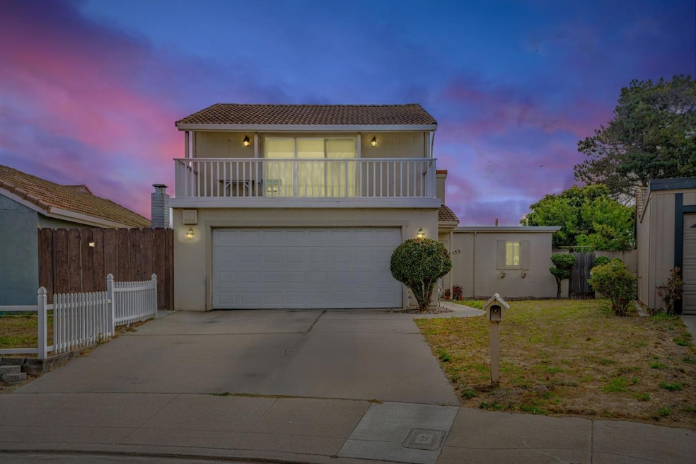
Tucked in a quiet North Salinas cul-de-sac, this home is ready for its next chapter. Inside, the layout features vaulted ceilings, a fireplace, and an open flow that invites reimagining. Whether you envision opening up the kitchen, adding modern finishes, or bringing in more natural light, this property offers the chance to create a space that reflects your style. The backyard is a true blank slate perfect for a garden, patio retreat, or weekend barbecues. An attached 2-car garage adds convenience for parking and storage. This isnt just a house its a project with potential. For the buyer with imagination and vision, 1055 Howe Circle is your opportunity to turn a solid foundation into the home youve always wanted, with the benefit of being close to schools, shopping, dining, and freeway access
Last Agent to Sell the Property
Beyond Simplified License #02148311 Listed on: 08/27/2025
| Date | Type | Sale Price | Title Company |
|---|---|---|---|
| Grant Deed | $610,000 | Orange Coast Title | |
| Grant Deed | $290,000 | First American Title | |
| Interfamily Deed Transfer | -- | Fidelity National Title Co | |
| Interfamily Deed Transfer | -- | -- |
| Date | Status | Loan Amount | Loan Type |
|---|---|---|---|
| Open | $21,350 | FHA | |
| Open | $598,951 | FHA | |
| Previous Owner | $232,000 | No Value Available | |
| Previous Owner | $180,055 | No Value Available | |
| Closed | $58,000 | No Value Available |
| Date | Event | Price | List to Sale | Price per Sq Ft |
|---|---|---|---|---|
| 10/07/2025 10/07/25 | Sold | $610,000 | +1.8% | $540 / Sq Ft |
| 09/02/2025 09/02/25 | Pending | -- | -- | -- |
| 08/27/2025 08/27/25 | For Sale | $599,000 | -- | $530 / Sq Ft |
| Year | Tax Paid | Tax Assessment Tax Assessment Total Assessment is a certain percentage of the fair market value that is determined by local assessors to be the total taxable value of land and additions on the property. | Land | Improvement |
|---|---|---|---|---|
| 2025 | $4,747 | $420,013 | $231,733 | $188,280 |
| 2024 | $4,747 | $411,779 | $227,190 | $184,589 |
| 2023 | $4,586 | $403,706 | $222,736 | $180,970 |
| 2022 | $4,413 | $395,791 | $218,369 | $177,422 |
| 2021 | $4,238 | $388,032 | $214,088 | $173,944 |
| 2020 | $4,120 | $384,054 | $211,893 | $172,161 |
| 2019 | $4,089 | $376,525 | $207,739 | $168,786 |
| 2018 | $4,035 | $369,143 | $203,666 | $165,477 |
| 2017 | $3,734 | $335,000 | $185,000 | $150,000 |
| 2016 | $3,616 | $318,000 | $175,000 | $143,000 |
| 2015 | $3,702 | $318,000 | $175,000 | $143,000 |
| 2014 | $2,594 | $235,000 | $130,000 | $105,000 |
Seller's Agent in 2025
Tuan Nguyen
Beyond Simplified
(916) 798-5798
1 in this area
89 Total Sales
Seller Co-Listing Agent in 2025
Brandon Ortiz
Beyond Simplified
(669) 205-2722
1 in this area
15 Total Sales
Buyer's Agent in 2025
Ramon Vazquez
RE/MAX
(831) 751-6900
1 in this area
17 Total Sales
Buyer Co-Listing Agent in 2025
Luci Serrano
RE/MAX
(831) 751-6900
2 in this area
14 Total Sales
Source: MLSListings
MLS Number: ML82019257
APN: 261-725-018-000
Disclaimer: Certain information contained herein is derived from information provided by parties other than Homes.com. All information provided is deemed reliable, but is not guaranteed to be accurate and should be independently verified.
![]() Property Information © 2026 MLSListings Inc. All rights reserved. Listing information is deemed reliable but not guaranteed. Certain information contained herein is derived from information which is the licensed property of, and copyrighted by, MLSListings Inc. The viewer acknowledges ownership and validity of its copyright. Information provided is for personal, non-commercial use by a viewer with a bona fide interest in the purchase or sale of real estate of the type being offered via this website or other electronic means. The viewer is prohibited from copying, redistributing or retransmitting any of the data or information provided by MLSListing, Inc.
Property Information © 2026 MLSListings Inc. All rights reserved. Listing information is deemed reliable but not guaranteed. Certain information contained herein is derived from information which is the licensed property of, and copyrighted by, MLSListings Inc. The viewer acknowledges ownership and validity of its copyright. Information provided is for personal, non-commercial use by a viewer with a bona fide interest in the purchase or sale of real estate of the type being offered via this website or other electronic means. The viewer is prohibited from copying, redistributing or retransmitting any of the data or information provided by MLSListing, Inc.
Ask me questions while you tour the home.