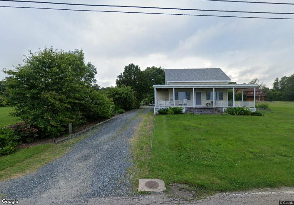
1057 Wapping Rd Middletown, RI 02842
Estimated Value: $682,000 - $1,631,673
4
Beds
2
Baths
1,789
Sq Ft
$702/Sq Ft
Est. Value
About This Home
This home is located at 1057 Wapping Rd, Middletown, RI 02842 and is currently estimated at $1,256,168, approximately $702 per square foot. 1057 Wapping Rd is a home located in Newport County with nearby schools including Middletown High School, The Pennfield School, and St George's School.
Ownership History
Date
Name
Owned For
Owner Type
Purchase Details
Closed on
Aug 31, 1998
Sold by
Cory Cecilia and Cory John
Bought by
Mazzulli Armand and Mazzulli Nancy M
Current Estimated Value
Home Financials for this Owner
Home Financials are based on the most recent Mortgage that was taken out on this home.
Original Mortgage
$143,800
Interest Rate
6.9%
Create a Home Valuation Report for This Property
The Home Valuation Report is an in-depth analysis detailing your home's value as well as a comparison with similar homes in the area
Home Values in the Area
Average Home Value in this Area
Purchase History
| Date | Buyer | Sale Price | Title Company |
|---|---|---|---|
| Mazzulli Armand | $160,000 | -- |
Source: Public Records
Mortgage History
| Date | Status | Borrower | Loan Amount |
|---|---|---|---|
| Open | Mazzulli Armand | $318,681 | |
| Closed | Mazzulli Armand | $25,100 | |
| Closed | Mazzulli Armand | $143,800 |
Source: Public Records
Tax History Compared to Growth
Tax History
| Year | Tax Paid | Tax Assessment Tax Assessment Total Assessment is a certain percentage of the fair market value that is determined by local assessors to be the total taxable value of land and additions on the property. | Land | Improvement |
|---|---|---|---|---|
| 2025 | $14,577 | $1,072,600 | $559,800 | $512,800 |
| 2024 | $13,922 | $1,072,600 | $559,800 | $512,800 |
| 2023 | $12,110 | $647,600 | $300,000 | $347,600 |
| 2022 | $11,560 | $647,600 | $300,000 | $347,600 |
| 2021 | $0 | $647,600 | $300,000 | $347,600 |
| 2020 | $0 | $510,200 | $233,200 | $277,000 |
| 2018 | $0 | $510,200 | $233,200 | $277,000 |
| 2016 | $0 | $478,300 | $203,400 | $274,900 |
| 2015 | -- | $478,300 | $203,400 | $274,900 |
| 2014 | -- | $457,000 | $186,600 | $270,400 |
| 2013 | -- | $457,000 | $186,600 | $270,400 |
Source: Public Records
Map
Nearby Homes
- 79 Peckham Ln
- 225 Old Mill Ln
- 222 Peckham Ave
- 180 Cottontail Dr
- 318 Mitchell's Ln
- 0 Indian Ave
- 362 Bramans Ln
- 515 Indian Ave
- 126 Mitchells Ln
- 415 Wapping Rd
- 119 Corey Ln
- 223 Corey Ln
- 0 Saltwood Dr
- 18 Randall Ln
- 310 Corey Ln
- 16 Ward Ave
- 481 Oliphant Ln
- 141 Gray Craig Rd
- 836 Forest Park
- 0 Honeyman Ave
- 1035 Wapping Rd
- 1067 Wapping Rd
- 1049 Wapping Rd
- 1111 Wapping Rd
- 1021 Wapping Rd
- 1023 Wapping Rd
- 1036 Wapping Rd
- 1064 Wapping Rd
- 1078 Wapping Rd
- 1011 Wapping Rd
- 14 Old Mill Ln
- 0 Wapping Rd
- 1094 Wapping Rd
- 1000 Wapping Rd
- 1116 Wapping Rd
- 997 Wapping Rd
- 1141 Wapping Rd
- 24 Old Mill Ln
- 955 Wapping Rd
- 8 Old Mill Ln