
Seller's Agent in 2025
Kristen McBeth
United Country - Southern States Realty
(601) 249-6101
159 Total Sales
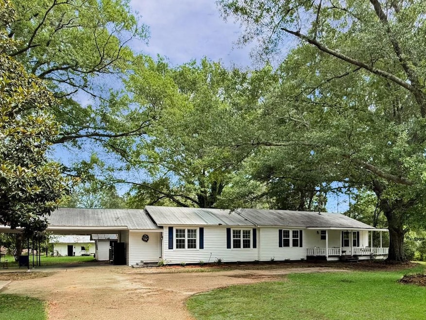


Completely Renovated 4 Bed, 2 Bath Country Home on 2.5 Acres with Workshop & Barn Welcome to peaceful country living! This beautifully renovated 4 bedroom, 2 bath home is tucked away on a quiet road and sits on 2.45+/- picturesque acres. Inside, you'll find fresh paint, new flooring, and light fixtures, as well as updated kitchen and baths. The spacious layout includes a cozy breakfast room that opens to a huge 16x20 covered back porch- also accessible through French doors from the private primary suite. Outside, enjoy a stunning yard adorned with mature trees and blooming flowers. A large workshop, barn, and additional storage shed provide ample space for hobbies, animals, or equipment. This move-in ready property is perfect for those seeking tranquility, functionality, and room to roam.
Last Agent to Sell the Property
United Country - Southern States Realty License #S57510 Listed on: 06/10/2025
| Date | Type | Sale Price | Title Company |
|---|---|---|---|
| Warranty Deed | -- | None Listed On Document | |
| Warranty Deed | -- | None Listed On Document | |
| Quit Claim Deed | -- | None Available | |
| Warranty Deed | -- | None Available | |
| Interfamily Deed Transfer | -- | None Available |
| Date | Status | Loan Amount | Loan Type |
|---|---|---|---|
| Open | $247,350 | New Conventional |
| Date | Event | Price | List to Sale | Price per Sq Ft |
|---|---|---|---|---|
| 09/10/2025 09/10/25 | Sold | -- | -- | -- |
| 08/04/2025 08/04/25 | Pending | -- | -- | -- |
| 06/10/2025 06/10/25 | For Sale | $255,500 | -- | $123 / Sq Ft |
| Year | Tax Paid | Tax Assessment Tax Assessment Total Assessment is a certain percentage of the fair market value that is determined by local assessors to be the total taxable value of land and additions on the property. | Land | Improvement |
|---|---|---|---|---|
| 2025 | $1,512 | $11,240 | $0 | $0 |
| 2024 | $1,325 | $9,795 | $0 | $0 |
| 2023 | $1,161 | $8,717 | $0 | $0 |
| 2022 | $1,151 | $8,805 | $0 | $0 |
| 2021 | $1,147 | $8,805 | $0 | $0 |
| 2020 | $1,223 | $9,388 | $0 | $0 |
| 2019 | $0 | $6,411 | $0 | $0 |
| 2018 | $0 | $6,689 | $0 | $0 |
| 2017 | $0 | $6,689 | $0 | $0 |
| 2016 | $0 | $6,322 | $0 | $0 |
| 2015 | -- | $6,125 | $0 | $0 |
| 2014 | -- | $5,938 | $0 | $0 |
| 2013 | -- | $5,934 | $0 | $0 |
Seller's Agent in 2025
Kristen McBeth
United Country - Southern States Realty
(601) 249-6101
159 Total Sales
Buyer's Agent in 2025
JoJo Kent
Doug Rushing Realty of McComb
(601) 810-6371
80 Total Sales
Source: MLS United
MLS Number: 144751
APN: 701220
Disclaimer: Certain information contained herein is derived from information provided by parties other than Homes.com. All information provided is deemed reliable, but is not guaranteed to be accurate and should be independently verified.
![]() Information is deemed to be reliable but not guaranteed. Copyright 2026 MLS United, LLC.
Information is deemed to be reliable but not guaranteed. Copyright 2026 MLS United, LLC.