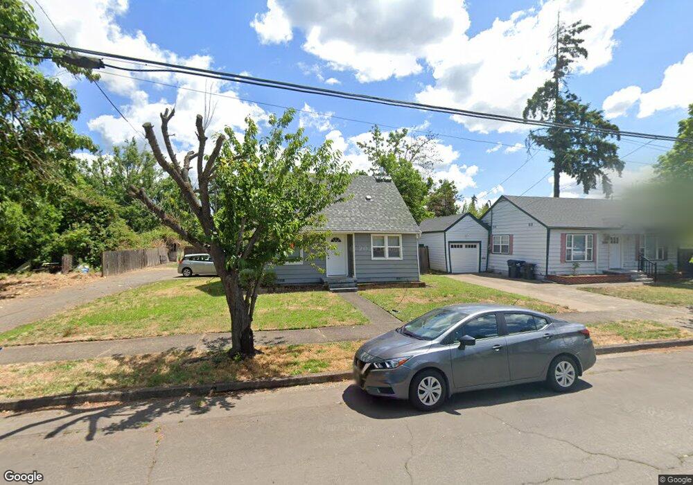
1059 4th St Unit 1 Springfield, OR 97477
Midtown South Springfield NeighborhoodEstimated Value: $362,000 - $405,000
4
Beds
2
Baths
1,759
Sq Ft
$218/Sq Ft
Est. Value
About This Home
This home is located at 1059 4th St Unit 1, Springfield, OR 97477 and is currently estimated at $384,021, approximately $218 per square foot. 1059 4th St Unit 1 is a home located in Lane County with nearby schools including Two Rivers Dos Rios Elementary School, Hamlin Middle School, and Springfield High School.
Ownership History
Date
Name
Owned For
Owner Type
Purchase Details
Closed on
Sep 6, 2023
Sold by
Michaud Lizann
Bought by
Lizann Michaud Trust and Michaud
Current Estimated Value
Purchase Details
Closed on
Sep 29, 2017
Sold by
Speer Barbara N
Bought by
Rock Sharon M and Sharon M Rock Family Trust
Purchase Details
Closed on
Jul 26, 2017
Sold by
Rock Sharon M
Bought by
Michaud Lizann
Purchase Details
Closed on
Jun 26, 2009
Sold by
Rock Sharon M
Bought by
Sharon M Rock Family Trust
Purchase Details
Closed on
Jun 23, 2003
Sold by
Speer Avery H
Bought by
Helen Wirth Revocable Trust
Purchase Details
Closed on
Mar 19, 2001
Sold by
Fall Creek Rental & Leasing Family Ltd P
Bought by
Helen Wirth Revocable Trust
Create a Home Valuation Report for This Property
The Home Valuation Report is an in-depth analysis detailing your home's value as well as a comparison with similar homes in the area
Home Values in the Area
Average Home Value in this Area
Purchase History
| Date | Buyer | Sale Price | Title Company |
|---|---|---|---|
| Lizann Michaud Trust | -- | None Listed On Document | |
| Rock Sharon M | $200,000 | Western Title & Escrow Co | |
| Michaud Lizann | $200,000 | Western Title & Escrow Co | |
| Sharon M Rock Family Trust | -- | None Available | |
| Helen Wirth Revocable Trust | $45,855 | -- | |
| Helen Wirth Revocable Trust | -- | -- |
Source: Public Records
Tax History Compared to Growth
Tax History
| Year | Tax Paid | Tax Assessment Tax Assessment Total Assessment is a certain percentage of the fair market value that is determined by local assessors to be the total taxable value of land and additions on the property. | Land | Improvement |
|---|---|---|---|---|
| 2025 | $3,178 | $173,293 | -- | -- |
| 2024 | $3,126 | $168,246 | -- | -- |
| 2023 | $3,126 | $163,346 | $0 | $0 |
| 2022 | $2,895 | $158,589 | $0 | $0 |
| 2021 | $2,844 | $153,970 | $0 | $0 |
| 2020 | $2,761 | $149,486 | $0 | $0 |
| 2019 | $2,678 | $145,133 | $0 | $0 |
| 2018 | $2,524 | $136,802 | $0 | $0 |
| 2017 | $2,427 | $136,802 | $0 | $0 |
| 2016 | $2,376 | $132,817 | $0 | $0 |
| 2015 | $2,308 | $128,949 | $0 | $0 |
| 2014 | $2,273 | $125,193 | $0 | $0 |
Source: Public Records
Map
Nearby Homes
- 1109 4th St
- 306 Broadway St
- 736 5th St
- 617 G St
- 1205 Mill St
- 239 D St
- 641 City View Blvd
- 835 Willacade Ct
- 0 Summit Blvd Unit 6305 24210629
- 1180 12th St
- 952 Summit Blvd
- 1756 10th St
- 428 W Centennial Blvd
- 436 W M St
- 488 Main St
- 1271 Centennial Blvd
- 1938 7th St
- 930 Prescott Ln
- 475 Riverview Blvd
- 552 W D St