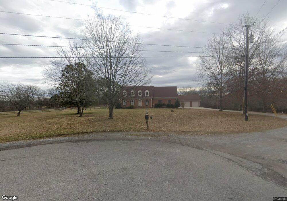
1059 N Sugartree Ln Gallatin, TN 37066
Estimated Value: $641,000 - $779,909
--
Bed
2
Baths
3,056
Sq Ft
$230/Sq Ft
Est. Value
About This Home
This home is located at 1059 N Sugartree Ln, Gallatin, TN 37066 and is currently estimated at $703,477, approximately $230 per square foot. 1059 N Sugartree Ln is a home located in Sumner County with nearby schools including Station Camp Elementary School, Station Camp Middle School, and Station Camp High School.
Ownership History
Date
Name
Owned For
Owner Type
Purchase Details
Closed on
Aug 1, 2008
Sold by
Taylor Robert T
Bought by
Zlibut Samuel and Zlibut Margareta
Current Estimated Value
Home Financials for this Owner
Home Financials are based on the most recent Mortgage that was taken out on this home.
Original Mortgage
$150,000
Outstanding Balance
$98,642
Interest Rate
6.37%
Mortgage Type
Unknown
Estimated Equity
$604,835
Purchase Details
Closed on
Mar 27, 1997
Sold by
Shepherd Shephard C and Shepherd Ronda B
Bought by
Taylor Robert T
Create a Home Valuation Report for This Property
The Home Valuation Report is an in-depth analysis detailing your home's value as well as a comparison with similar homes in the area
Home Values in the Area
Average Home Value in this Area
Purchase History
| Date | Buyer | Sale Price | Title Company |
|---|---|---|---|
| Zlibut Samuel | $257,500 | None Available | |
| Taylor Robert T | $160,000 | -- |
Source: Public Records
Mortgage History
| Date | Status | Borrower | Loan Amount |
|---|---|---|---|
| Open | Zlibut Samuel | $150,000 |
Source: Public Records
Tax History Compared to Growth
Tax History
| Year | Tax Paid | Tax Assessment Tax Assessment Total Assessment is a certain percentage of the fair market value that is determined by local assessors to be the total taxable value of land and additions on the property. | Land | Improvement |
|---|---|---|---|---|
| 2024 | $2,577 | $181,325 | $48,525 | $132,800 |
| 2023 | $2,982 | $132,425 | $47,675 | $84,750 |
| 2022 | $2,301 | $132,425 | $47,675 | $84,750 |
| 2021 | $2,301 | $101,725 | $47,675 | $54,050 |
| 2020 | $2,301 | $101,725 | $47,675 | $54,050 |
| 2019 | $2,301 | $0 | $0 | $0 |
| 2018 | $1,573 | $0 | $0 | $0 |
| 2017 | $1,573 | $0 | $0 | $0 |
| 2016 | $1,573 | $0 | $0 | $0 |
| 2015 | -- | $0 | $0 | $0 |
| 2014 | -- | $0 | $0 | $0 |
Source: Public Records
Map
Nearby Homes
- 705 Tompkins Ln
- 414 Rawling Ln
- 701 Tompkins Ln
- 407 Rawling Ln
- 410 Rawling Ln
- 408 Rawling Ln
- 406 Rawling Ln
- 404 Rawling Ln
- 400 Rawling Ln
- 321 Rawling Ln
- 113 Cryer Dr
- 315 Rawling Ln
- 113 Joyner Ct
- 119 Joyner Ct
- 305 Rawling Ln
- 1005 Regency Ct
- Albright Plan at McCain's Station
- 384 Tompkins Ln
- 382 Tompkins Ln
- 1670 Long Hollow Pike
- 1055 N Sugartree Ln
- 1054 N Sugartree Ln
- 1051 N Sugartree Ln
- 1050 N Sugartree Ln
- 1049 N Sugartree Ln
- 1045 N Sugartree Ln
- 1046 N Sugartree Ln
- 1046 Brighton Ln
- 1046 Brighton Ln Unit 72
- 1046 Brighton Ln
- 1077 Montrose Dr
- 1042 Brighton Ln
- 1042 Brighton Ln Unit 73
- 1042 Brighton Ln
- 1073 Montrose Dr
- 1073 Montrose Dr
- 1073 Montrose Dr Unit 70
- 1073 Montrose Dr
- 1043 N Sugartree Ln
- 1038 Brighton Ln