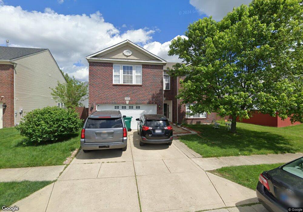
10592 Carrie Ln Indianapolis, IN 46231
Estimated Value: $338,000 - $367,000
4
Beds
3
Baths
3,646
Sq Ft
$97/Sq Ft
Est. Value
About This Home
This home is located at 10592 Carrie Ln, Indianapolis, IN 46231 and is currently estimated at $354,741, approximately $97 per square foot. 10592 Carrie Ln is a home located in Hendricks County with nearby schools including White Oak Elementary School, Avon Intermediate School West, and Cedar Elementary School.
Ownership History
Date
Name
Owned For
Owner Type
Purchase Details
Closed on
Aug 19, 2005
Sold by
Kefela Solomon G
Bought by
Kefela Solomon G and Gezehey Elsa A
Current Estimated Value
Home Financials for this Owner
Home Financials are based on the most recent Mortgage that was taken out on this home.
Original Mortgage
$100,000
Interest Rate
5.82%
Mortgage Type
New Conventional
Purchase Details
Closed on
May 27, 2005
Sold by
Bentwood Development Llc
Bought by
C P Morgan Communities Lp
Create a Home Valuation Report for This Property
The Home Valuation Report is an in-depth analysis detailing your home's value as well as a comparison with similar homes in the area
Home Values in the Area
Average Home Value in this Area
Purchase History
| Date | Buyer | Sale Price | Title Company |
|---|---|---|---|
| Kefela Solomon G | -- | None Available | |
| Kefela Solomon G | -- | None Available | |
| Kefela Solmon G | -- | None Available | |
| C P Morgan Communities Lp | -- | None Available |
Source: Public Records
Mortgage History
| Date | Status | Borrower | Loan Amount |
|---|---|---|---|
| Closed | Kefela Solmon G | $100,000 |
Source: Public Records
Tax History Compared to Growth
Tax History
| Year | Tax Paid | Tax Assessment Tax Assessment Total Assessment is a certain percentage of the fair market value that is determined by local assessors to be the total taxable value of land and additions on the property. | Land | Improvement |
|---|---|---|---|---|
| 2024 | $3,392 | $301,200 | $53,100 | $248,100 |
| 2023 | $3,124 | $279,100 | $48,700 | $230,400 |
| 2022 | $3,053 | $270,800 | $46,400 | $224,400 |
| 2021 | $2,494 | $221,500 | $43,800 | $177,700 |
| 2020 | $2,326 | $205,300 | $43,800 | $161,500 |
| 2019 | $2,224 | $194,200 | $40,900 | $153,300 |
| 2018 | $2,201 | $189,100 | $40,900 | $148,200 |
| 2017 | $1,727 | $170,700 | $40,900 | $129,800 |
| 2016 | $1,664 | $166,400 | $40,900 | $125,500 |
| 2014 | $1,560 | $156,000 | $37,800 | $118,200 |
Source: Public Records
Map
Nearby Homes
- 10597 Cyrus Dr
- 10775 Cyrus Dr
- 10761 Parker Dr
- 10869 Parker Dr
- 1585 Danielle Dr
- 10901 Parker Dr
- 1556 Danielle Dr
- 10816 Zimmerman Ln
- 10795 Albertson Dr
- 10935 Parker Dr
- 10882 Zimmerman Ln
- 2289 S County Road 1050 E
- 1392 Broyles Ln
- 1449 Danielle Dr
- 1422 Fortner Dr
- 10699 Crane Dr
- 1633 Composer Way
- 1940 Orchid Bloom Dr
- 8945 Poppy Ln
- 1660 Orchestra Way
- 10604 Carrie Ln
- 10590 Carrie Ln
- 10619 Wyatt Dr
- 10616 Carrie Ln
- 10631 Wyatt Dr
- 10575 Carrie Ln
- 10573 Carrie Ln
- 10581 Carrie Ln
- 10628 Carrie Ln
- 10618 Wyatt Dr
- 10606 Wyatt Dr
- 10645 Wyatt Dr
- 10630 Wyatt Dr
- 10591 Carrie Ln
- 10585 Carrie Ln
- 10605 Carrie Ln
- 10594 Wyatt Dr
- 10557 Wyatt Dr
- 10642 Wyatt Dr
- 10640 Carrie Ln