Estimated Value: $879,810 - $1,187,000
3
Beds
3
Baths
2,600
Sq Ft
$396/Sq Ft
Est. Value
About This Home
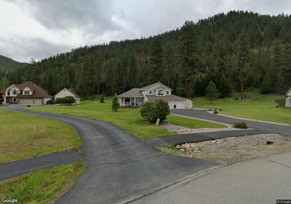
This home is located at 10592 Nez Perce Loop, Lolo, MT 59847 and is currently estimated at $1,030,203, approximately $396 per square foot. 10592 Nez Perce Loop is a home located in Missoula County with nearby schools including Lolo Elementary School, Lolo Middle School, and Sentinel High School.
Ownership History
Date
Name
Owned For
Owner Type
Purchase Details
Closed on
Jan 14, 2005
Sold by
Bob Martz Homes Inc
Bought by
Brester Alvin and Brester Angel
Current Estimated Value
Home Financials for this Owner
Home Financials are based on the most recent Mortgage that was taken out on this home.
Original Mortgage
$301,008
Outstanding Balance
$149,455
Interest Rate
5.5%
Mortgage Type
Unknown
Estimated Equity
$880,748
Purchase Details
Closed on
Jun 29, 2004
Sold by
Boyd Thedore and Boyd Elaine
Bought by
Bob Martz Homes Inc
Home Financials for this Owner
Home Financials are based on the most recent Mortgage that was taken out on this home.
Original Mortgage
$224,250
Interest Rate
6.29%
Mortgage Type
Construction
Purchase Details
Closed on
Aug 28, 2003
Sold by
Bitterroot Investments Exchange Llc
Bought by
Boyd Theodore and Boyd Elaine
Create a Home Valuation Report for This Property
The Home Valuation Report is an in-depth analysis detailing your home's value as well as a comparison with similar homes in the area
Purchase History
| Date | Buyer | Sale Price | Title Company |
|---|---|---|---|
| Brester Alvin | -- | -- | |
| Bob Martz Homes Inc | -- | -- | |
| Boyd Theodore | -- | -- |
Source: Public Records
Mortgage History
| Date | Status | Borrower | Loan Amount |
|---|---|---|---|
| Open | Brester Alvin | $301,008 | |
| Previous Owner | Bob Martz Homes Inc | $224,250 | |
| Closed | Bob Martz Homes Inc | $100,000 | |
| Closed | Brester Alvin | $56,439 |
Source: Public Records
Tax History
| Year | Tax Paid | Tax Assessment Tax Assessment Total Assessment is a certain percentage of the fair market value that is determined by local assessors to be the total taxable value of land and additions on the property. | Land | Improvement |
|---|---|---|---|---|
| 2025 | $7,351 | $941,600 | $227,565 | $714,035 |
| 2024 | $8,534 | $739,000 | $149,739 | $589,261 |
| 2023 | $7,286 | $739,000 | $149,739 | $589,261 |
| 2022 | $6,037 | $510,600 | $0 | $0 |
| 2021 | $5,375 | $510,600 | $0 | $0 |
| 2020 | $4,922 | $454,900 | $0 | $0 |
| 2019 | $4,891 | $454,900 | $0 | $0 |
| 2018 | $4,611 | $439,898 | $0 | $0 |
| 2017 | $4,647 | $439,898 | $0 | $0 |
| 2016 | $5,095 | $488,100 | $0 | $0 |
| 2015 | $4,882 | $488,100 | $0 | $0 |
| 2014 | $4,496 | $249,895 | $0 | $0 |
Source: Public Records
Map
Nearby Homes
- 10596 Nez Perce Loop
- 10636 Nez Perce Loop
- 12196 Cowcatcher Dr
- 10131 Barns Ct
- 9883 Hatton Ln
- 9745 U S 12
- 11625 Highway 12 W
- 13275 Balsam Root Rd
- 11327 Sleeman Ln
- 9280 Mormon Creek Rd
- 8350 Vann Dr
- 10200 Sleeman Creek Rd
- 10961 Stella Blue Dr
- 10972 Stella Blue Dr
- 12326 Nature Ct
- 12458 Nature Ct
- 15100 Rock Ridge Rd
- 12884 Cameron's Way
- 430 Claremont St
- 6896 Jack Pine Ct
- 10572 Nez Perce Loop
- 10587 Nez Perce Loop
- 10569 Nez Perce Loop
- 10700 Allen Ln
- 10556 Nez Perce Loop
- 10551 Nez Perce Loop
- 10750 Allen Ln
- 10538 Nez Perce Loop
- 10660 Nez Perce Loop
- 10677 Nez Perce Loop
- 10533 Nez Perce Loop
- 10516 Nez Perce Loop
- 10780 Allen Ln
- 10678 Nez Perce Loop
- 10650 Allen Ln
- Lot 22 Nez Perce Loop
- 12773 Conestoga Way
- 12773 Conestoga Way
- 10515 Nez Perce Loop
- Lot 21 Nez Perce Loop
Your Personal Tour Guide
Ask me questions while you tour the home.