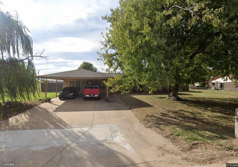
106 E Larry Rd Shawnee, OK 74804
Estimated Value: $154,000 - $225,000
3
Beds
2
Baths
1,712
Sq Ft
$112/Sq Ft
Est. Value
About This Home
This home is located at 106 E Larry Rd, Shawnee, OK 74804 and is currently estimated at $191,366, approximately $111 per square foot. 106 E Larry Rd is a home located in Pottawatomie County with nearby schools including Dale Elementary School, Dale Middle School, and Dale High School.
Ownership History
Date
Name
Owned For
Owner Type
Purchase Details
Closed on
Jan 17, 2012
Sold by
Graham Sharon G
Bought by
Reeves Mack and Reeves Kathy
Current Estimated Value
Purchase Details
Closed on
May 6, 2009
Sold by
Graham Sharon G
Bought by
Reeves Mack and Reeves Jor Kathy
Purchase Details
Closed on
May 20, 1995
Sold by
Story Patricia and Story Jerry
Bought by
Brewer Stephen and Brewer Victoria
Create a Home Valuation Report for This Property
The Home Valuation Report is an in-depth analysis detailing your home's value as well as a comparison with similar homes in the area
Purchase History
| Date | Buyer | Sale Price | Title Company |
|---|---|---|---|
| Reeves Mack | -- | None Available | |
| Reeves Mack | $36,000 | None Available | |
| Brewer Stephen | $65,000 | -- |
Source: Public Records
Tax History
| Year | Tax Paid | Tax Assessment Tax Assessment Total Assessment is a certain percentage of the fair market value that is determined by local assessors to be the total taxable value of land and additions on the property. | Land | Improvement |
|---|---|---|---|---|
| 2025 | $919 | $8,826 | $1,605 | $7,221 |
| 2024 | $907 | $8,406 | $1,529 | $6,877 |
| 2023 | $907 | $8,005 | $1,452 | $6,553 |
| 2022 | $783 | $7,624 | $1,379 | $6,245 |
| 2021 | $818 | $7,624 | $1,379 | $6,245 |
| 2020 | $779 | $6,916 | $1,244 | $5,672 |
| 2019 | $771 | $6,587 | $1,144 | $5,443 |
| 2018 | $726 | $6,273 | $1,077 | $5,196 |
| 2017 | $667 | $5,975 | $1,009 | $4,966 |
| 2016 | $557 | $5,690 | $980 | $4,710 |
| 2015 | $509 | $5,419 | $1,001 | $4,418 |
| 2014 | $509 | $5,161 | $944 | $4,217 |
Source: Public Records
Map
Nearby Homes
- 8 Clark Cir
- 37802 W Old Highway 270
- 10667 N Kickapoo Ave
- 2700 Woodlawn Ct
- 2715 Woodlawn Ct
- 2727 Woodlawn Ct
- 38172 W 45th St
- 27 Willowbrook
- 13804 Coker Rd
- 36601 W 45th St
- 121 Lake Shore Dr
- 129 Lake Shore Dr
- 0 Gaddy Rd Unit OKC1215621
- 37614 W Macarthur St
- 0 Coker Rd
- 36236 Prairie Ridge Ct
- 36021 Prairie Rdg Rd
- 35502 Pecan Grove Rd
- 1922 Ridge Crest Dr
- 36506 Garretts Lake Rd
Your Personal Tour Guide
Ask me questions while you tour the home.