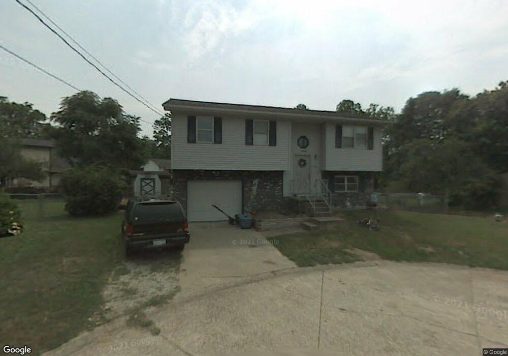
106 Scott Ln Scott Depot, WV 25560
Estimated Value: $228,744 - $250,000
3
Beds
2
Baths
1,452
Sq Ft
$164/Sq Ft
Est. Value
About This Home
This home is located at 106 Scott Ln, Scott Depot, WV 25560 and is currently estimated at $238,686, approximately $164 per square foot. 106 Scott Ln is a home located in Putnam County with nearby schools including Teays Valley Christian School and Calvary Baptist Academy.
Ownership History
Date
Name
Owned For
Owner Type
Purchase Details
Closed on
Apr 30, 2020
Sold by
Am Investments Llc
Bought by
Arthur Mackenzie Brooke
Current Estimated Value
Home Financials for this Owner
Home Financials are based on the most recent Mortgage that was taken out on this home.
Original Mortgage
$150,505
Outstanding Balance
$132,489
Interest Rate
3.3%
Mortgage Type
New Conventional
Estimated Equity
$106,197
Purchase Details
Closed on
May 22, 2017
Sold by
Payne Matthew Brent and Payne Mathew B
Bought by
Payne Matthew Brent
Create a Home Valuation Report for This Property
The Home Valuation Report is an in-depth analysis detailing your home's value as well as a comparison with similar homes in the area
Home Values in the Area
Average Home Value in this Area
Purchase History
| Date | Buyer | Sale Price | Title Company |
|---|---|---|---|
| Arthur Mackenzie Brooke | $149,000 | None Available | |
| Payne Matthew Brent | -- | None Available |
Source: Public Records
Mortgage History
| Date | Status | Borrower | Loan Amount |
|---|---|---|---|
| Open | Arthur Mackenzie Brooke | $150,505 |
Source: Public Records
Tax History Compared to Growth
Tax History
| Year | Tax Paid | Tax Assessment Tax Assessment Total Assessment is a certain percentage of the fair market value that is determined by local assessors to be the total taxable value of land and additions on the property. | Land | Improvement |
|---|---|---|---|---|
| 2025 | $1,338 | $105,840 | $19,020 | $86,820 |
| 2024 | $1,338 | $99,120 | $19,020 | $80,100 |
| 2023 | $1,117 | $96,360 | $19,020 | $77,340 |
| 2022 | $1,096 | $90,900 | $15,900 | $75,000 |
| 2021 | $996 | $82,260 | $15,900 | $66,360 |
| 2020 | $1,091 | $90,180 | $20,220 | $69,960 |
| 2019 | $1,047 | $85,260 | $20,220 | $65,040 |
| 2018 | $1,041 | $84,540 | $20,220 | $64,320 |
| 2017 | $1,065 | $85,860 | $23,340 | $62,520 |
| 2016 | $749 | $60,000 | $10,200 | $49,800 |
| 2015 | $716 | $65,880 | $16,500 | $49,380 |
| 2014 | $716 | $56,940 | $9,840 | $47,100 |
Source: Public Records
Map
Nearby Homes
- TBD Hedrick Rd
- 115 Rolling Meadows Dr
- 107 Countryside Rd
- 0 Tbd Hedrick Rd
- 200 Bent Tree Estates
- 146 Tyler Way
- 107 Woodstone Dr
- 149 Beechwood Estates
- 7732 Teays Valley Rd
- 0 Hedrick Rd Unit WVPU2000008
- Lot 12 Crooked Creek Rd
- 75 Poinsettia Dr
- 00 Hedrick Rd
- 600 Hedrick Rd
- 5431 Teays Valley Rd
- 106 Heather Ct
- 100 Devonshire Dr
- 0 Poplar Estates Unit 272168
- Lot 10 Crooked Creek Rd
- Lot 9 Crooked Creek Rd