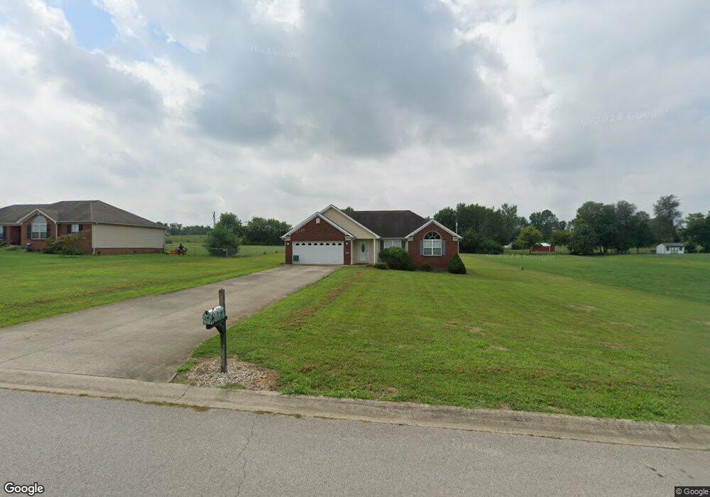
106 Station Dr Salvisa, KY 40372
Estimated Value: $255,945 - $370,000
3
Beds
2
Baths
1,436
Sq Ft
$213/Sq Ft
Est. Value
About This Home
This home is located at 106 Station Dr, Salvisa, KY 40372 and is currently estimated at $306,236, approximately $213 per square foot. 106 Station Dr is a home located in Mercer County with nearby schools including Mercer County Elementary School, Mercer County Intermediate School, and King Middle School.
Ownership History
Date
Name
Owned For
Owner Type
Purchase Details
Closed on
Mar 16, 2016
Sold by
Miller Carlos Fix and Miller Nancy Sue
Bought by
Miller Carlos Fix and Miller Family Prtection Trust
Current Estimated Value
Purchase Details
Closed on
Jul 11, 2008
Sold by
Dunningham Larry and Cunningham Alicia
Bought by
Carlos Miller And Nancy Miller Revocable
Purchase Details
Closed on
Sep 19, 2006
Sold by
Derringer Designed Homes Llc
Bought by
Cunningham Larry and Cunningham Alicia
Home Financials for this Owner
Home Financials are based on the most recent Mortgage that was taken out on this home.
Original Mortgage
$122,000
Interest Rate
6.71%
Mortgage Type
Commercial
Purchase Details
Closed on
Aug 19, 2005
Sold by
Cherokee Development Co
Bought by
Derringer Designed Homes Llc
Create a Home Valuation Report for This Property
The Home Valuation Report is an in-depth analysis detailing your home's value as well as a comparison with similar homes in the area
Home Values in the Area
Average Home Value in this Area
Purchase History
| Date | Buyer | Sale Price | Title Company |
|---|---|---|---|
| Miller Carlos Fix | -- | Attorney | |
| Carlos Miller And Nancy Miller Revocable | $156,000 | -- | |
| Cunningham Larry | $152,500 | -- | |
| Derringer Designed Homes Llc | $25,000 | -- |
Source: Public Records
Mortgage History
| Date | Status | Borrower | Loan Amount |
|---|---|---|---|
| Previous Owner | Cunningham Larry | $122,000 | |
| Previous Owner | Cunningham Larry | $30,500 |
Source: Public Records
Tax History Compared to Growth
Tax History
| Year | Tax Paid | Tax Assessment Tax Assessment Total Assessment is a certain percentage of the fair market value that is determined by local assessors to be the total taxable value of land and additions on the property. | Land | Improvement |
|---|---|---|---|---|
| 2024 | $1,971 | $164,903 | $25,000 | $139,903 |
| 2023 | $1,989 | $164,903 | $0 | $0 |
| 2022 | $1,948 | $164,903 | $0 | $0 |
| 2021 | $1,961 | $164,903 | $0 | $0 |
| 2020 | $1,847 | $156,000 | $25,000 | $131,000 |
| 2019 | $1,875 | $156,000 | $25,000 | $131,000 |
| 2018 | $1,833 | $156,000 | $0 | $0 |
| 2017 | $1,771 | $156,000 | $0 | $0 |
| 2016 | $1,738 | $156,000 | $0 | $0 |
| 2015 | $1,689 | $156,000 | $25,000 | $131,000 |
| 2014 | $1,689 | $156,000 | $25,000 | $131,000 |
| 2010 | -- | $156,000 | $25,000 | $131,000 |
Source: Public Records
Map
Nearby Homes
- 110 Station Dr
- 143 Providence Rd
- 3062 Louisville Rd
- 110 Gracelynn Cir
- 125 Talmage-Mayo Rd
- 151 Man-O-war Dr
- 280 Talmage Mayo Rd
- 127 Man-O-war Dr
- Tract 3 Cole Rd
- Tract 3a Cole Rd
- 420 Cole Ln
- 935 Keenon Rd
- 241 Cottonwood St
- 4560 Louisville Rd
- 236 Main St
- 1111 Jackson Pike
- 2 Kirkwood Rd
- 3 Kirkwood Rd
- 4 Kirkwood Rd
- 165 Kirkwood Rd
- 108 Station Dr
- 102 Station Dr
- 0 Station Dr
- 112 Station Dr
- 100 Station Dr
- 107 Station Dr
- 105 Station Dr
- 109 Station Dr
- 111 Station Dr
- 103 Station Dr
- 3355 Louisville Rd
- 113 Station Dr
- 101 Station Dr
- 161 Cummins Ferry Rd
- 3339 Louisville Rd
- 3344 Louisville Rd
- 125 Cummins Ferry Rd
- 135 Cummins Ferry Rd
- Tract 20 Louisville Rd
- 3415 Louisville Rd