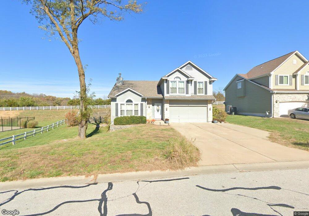
10610 Rowland Ave Kansas City, KS 66109
I-435 West KC-KS NeighborhoodEstimated Value: $374,000 - $434,000
4
Beds
3
Baths
1,730
Sq Ft
$231/Sq Ft
Est. Value
About This Home
This home is located at 10610 Rowland Ave, Kansas City, KS 66109 and is currently estimated at $399,814, approximately $231 per square foot. 10610 Rowland Ave is a home located in Wyandotte County with nearby schools including Piper Prairie Elementary School, Piper East Elementary School, and Piper Middle School.
Ownership History
Date
Name
Owned For
Owner Type
Purchase Details
Closed on
Oct 30, 2020
Sold by
Courtney Richard William and Courtney Elizabeth
Bought by
Felich Emily and Vaughn Mitchell
Current Estimated Value
Home Financials for this Owner
Home Financials are based on the most recent Mortgage that was taken out on this home.
Original Mortgage
$253,817
Outstanding Balance
$226,266
Interest Rate
2.9%
Mortgage Type
FHA
Estimated Equity
$173,548
Purchase Details
Closed on
Jul 6, 2004
Sold by
Moss Donald and Moss Mary
Bought by
Courtney Richard and Courtney Elizabeth
Home Financials for this Owner
Home Financials are based on the most recent Mortgage that was taken out on this home.
Original Mortgage
$148,000
Interest Rate
6.31%
Mortgage Type
Purchase Money Mortgage
Create a Home Valuation Report for This Property
The Home Valuation Report is an in-depth analysis detailing your home's value as well as a comparison with similar homes in the area
Home Values in the Area
Average Home Value in this Area
Purchase History
| Date | Buyer | Sale Price | Title Company |
|---|---|---|---|
| Felich Emily | -- | None Available | |
| Courtney Richard | -- | Guarantee Title Of Wyandotte |
Source: Public Records
Mortgage History
| Date | Status | Borrower | Loan Amount |
|---|---|---|---|
| Open | Felich Emily | $253,817 | |
| Previous Owner | Courtney Richard | $148,000 | |
| Closed | Courtney Richard | $27,750 |
Source: Public Records
Tax History Compared to Growth
Tax History
| Year | Tax Paid | Tax Assessment Tax Assessment Total Assessment is a certain percentage of the fair market value that is determined by local assessors to be the total taxable value of land and additions on the property. | Land | Improvement |
|---|---|---|---|---|
| 2024 | $6,612 | $41,205 | $7,895 | $33,310 |
| 2023 | $6,529 | $37,783 | $8,152 | $29,631 |
| 2022 | $5,872 | $34,189 | $5,798 | $28,391 |
| 2021 | $5,046 | $29,843 | $5,888 | $23,955 |
| 2020 | $4,514 | $26,812 | $5,514 | $21,298 |
| 2019 | $4,422 | $26,287 | $5,352 | $20,935 |
| 2018 | $4,447 | $25,772 | $5,103 | $20,669 |
| 2017 | $4,211 | $24,719 | $5,083 | $19,636 |
| 2016 | $4,130 | $23,999 | $5,083 | $18,916 |
| 2015 | $4,125 | $23,529 | $5,083 | $18,446 |
| 2014 | $3,509 | $21,806 | $5,237 | $16,569 |
Source: Public Records
Map
Nearby Homes
- 2512 N 106th St
- 10649 Georgia Ave
- 10526 Rowland Ave
- 10529 Cleveland Ave
- 10812 Cleveland Ave
- 2600 N 109 St
- 2512 N 109th Terrace
- 13319 Parallel Pkwy
- 5270 N 103rd St
- 11143 Nogard Ave
- The Kinley Plan at Whispering Ridge - Swanson Farm at Whispering Ridge
- The Redbud Plan at Whispering Ridge - Swanson Farm at Whispering Ridge
- The Oakmont Plan at Whispering Ridge - Swanson Farm at Whispering Ridge
- 2538 N 111th Ct
- 2544 N 111th Ct
- 2532 N 111th Ct
- 11147 Rowland Ave
- 11150 Nogard Ave
- 11209 Nogard Ave
- 11201 Georgia Ave
- 10606 Rowland Ave
- 10616 Rowland Ave
- 10602 Rowland Ave
- 10611 Rowland Ave
- 10605 Rowland Ave
- 10620 Rowland Ave
- 2516 N 106th St
- 10625 Rowland Ave
- 10534 Rowland Ave
- 10624 Rowland Ave
- 2519 N 106th St
- 2615 N 107th St
- 10540 Nogard Ave
- 2607 N 107th St
- 10628 Rowland Ave
- 2508 N 106th St
- 10535 Rowland Ave
- 2601 N 107th St
- 10530 Rowland Ave
- 10629 Rowland Ave