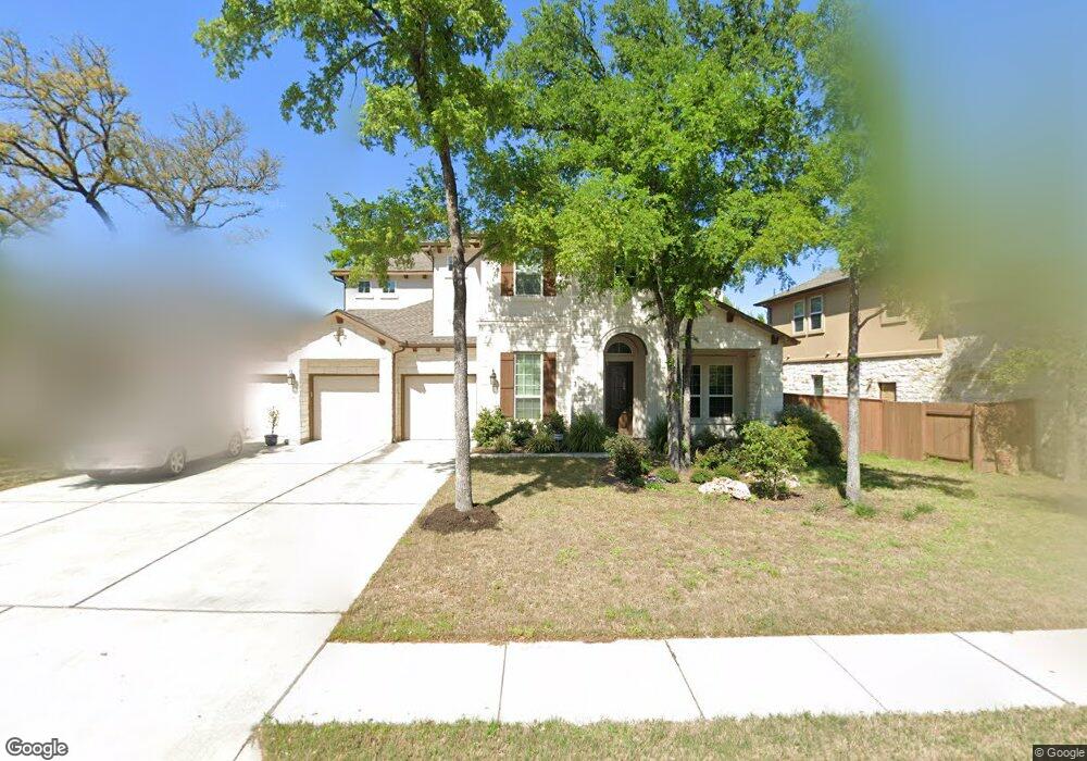
10621 Cannon Mark Way Austin, TX 78717
Avery Ranch NeighborhoodEstimated Value: $939,923 - $1,080,000
--
Bed
--
Bath
3,846
Sq Ft
$262/Sq Ft
Est. Value
About This Home
This home is located at 10621 Cannon Mark Way, Austin, TX 78717 and is currently estimated at $1,006,731, approximately $261 per square foot. 10621 Cannon Mark Way is a home with nearby schools including Purple Sage Elementary School, Pearson Ranch Middle, and McNeil High School.
Ownership History
Date
Name
Owned For
Owner Type
Purchase Details
Closed on
Mar 31, 2015
Sold by
Standard Pacific Of Texas Inc
Bought by
Zhou Jianshi and Zhang Yan
Current Estimated Value
Home Financials for this Owner
Home Financials are based on the most recent Mortgage that was taken out on this home.
Original Mortgage
$250,000
Outstanding Balance
$92,033
Interest Rate
3.82%
Mortgage Type
New Conventional
Estimated Equity
$914,698
Create a Home Valuation Report for This Property
The Home Valuation Report is an in-depth analysis detailing your home's value as well as a comparison with similar homes in the area
Home Values in the Area
Average Home Value in this Area
Purchase History
| Date | Buyer | Sale Price | Title Company |
|---|---|---|---|
| Zhou Jianshi | -- | None Available |
Source: Public Records
Mortgage History
| Date | Status | Borrower | Loan Amount |
|---|---|---|---|
| Open | Zhou Jianshi | $250,000 |
Source: Public Records
Tax History Compared to Growth
Tax History
| Year | Tax Paid | Tax Assessment Tax Assessment Total Assessment is a certain percentage of the fair market value that is determined by local assessors to be the total taxable value of land and additions on the property. | Land | Improvement |
|---|---|---|---|---|
| 2025 | $15,838 | $1,014,519 | -- | -- |
| 2024 | $15,838 | $922,290 | -- | -- |
| 2023 | $15,416 | $838,445 | $0 | $0 |
| 2022 | $16,956 | $762,223 | $0 | $0 |
| 2021 | $18,097 | $692,930 | $124,000 | $630,959 |
| 2020 | $16,026 | $629,936 | $110,362 | $519,574 |
| 2019 | $15,263 | $583,983 | $104,400 | $479,583 |
| 2018 | $14,535 | $578,678 | $90,950 | $487,728 |
| 2017 | $13,437 | $566,346 | $85,000 | $481,346 |
| 2016 | $12,783 | $561,450 | $85,000 | $476,450 |
| 2015 | $843 | $173,125 | $57,600 | $115,525 |
| 2014 | $843 | $34,854 | $0 | $0 |
Source: Public Records
Map
Nearby Homes
- 14405 Laurinburg Dr
- 10701 Copper Basin Cove
- 11612 Yeadon Way
- 10610 Wills Loop
- 11013 Avery Station Loop Unit 31
- 13920 Marathon Rd
- 14016 Tyburn Trail
- 14100 Laurinburg Dr
- 13604 Avery Trestle Ln Unit 17
- 12109 Maypole Bend
- 11200 Avery Station Loop Unit 13
- 13805 Wiregrass Way
- 12315 Maypole Bend Unit 1002
- 10904 Brazoria Ln Unit 88
- 11410 Culzean Castle Dr
- 15508 Staked Plains Loop
- 14500 Homestead Village Cir
- 11600 Santa Elena Ln
- 14100 Avery Ranch Blvd Unit 103
- 14100 Avery Ranch Blvd Unit 403
- 10617 Cannon Mark Way
- 10701 Cannon Mark Way
- 10613 Cannon Mark Way
- 10705 Cannon Mark Way
- 10609 Cannon Mark Way
- 10620 Cannon Mark Way
- 10700 Cannon Mark Way
- 14217 Genesee Trail
- 10605 Cannon Mark Way
- 14213 Genesee Trail
- 10704 Cannon Mark Way
- 14301 Genesee Trail
- 14305 Genesee Trail
- 14209 Genesee Trail
- 10601 Cannon Mark Way
- 10708 Cannon Mark Way
- 10510 Cannon Mark Way
- 14205 Genesee Trail
- 10716 Cannon Mark Way
- 14112 Abervil Trail