
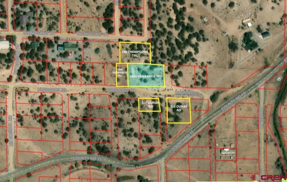

1063 Hubbard's Trail South Fork, CO 81154
1.42
Acres
$42,254
Price per Acre
61,855
Sq Ft Lot
Highlights
- Mountain View
- Wooded Lot
- Partially Fenced Property
About This Lot
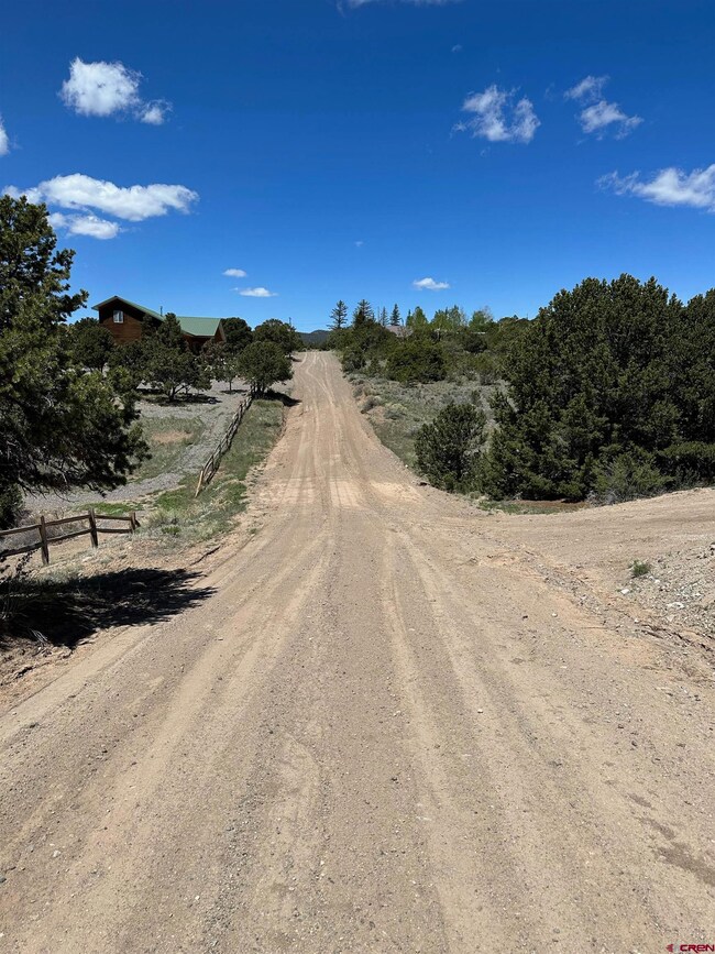
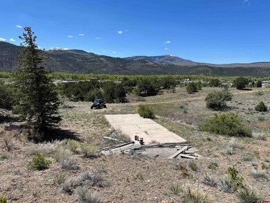
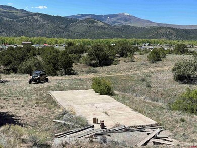
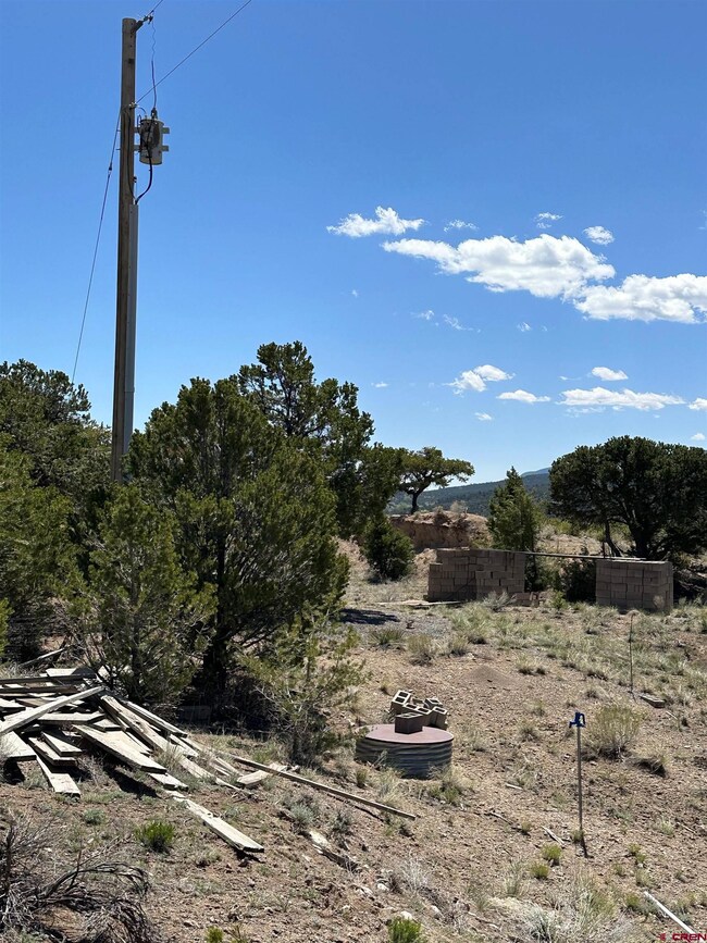
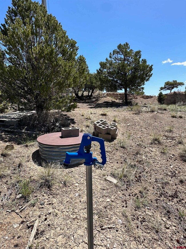
As of July 20241.4 acres in Alpine Village with huge views, power on property, A PRODUCTIVE WELL WITH A NEW PUMP AND PRESSURE TANK, and no HOA or covenants telling you what you can and can't do. There's a 18' x 36' concrete slab already on the property along with apx 800 cinder blocks and a considerable amount of excavation work has already been done. Short Term Rentals are allowed per County regulations. Rio Grande County regulates camping with self contained camper or tent for up to 180 days annually with County permit. This offering includes a total of nine adjacent lots with 5 unique addresses, i.e. 198 Thompsons Trl, 1059 Hubbards Trl, 1063 Hubbards Trl, 337 Ouray Rd and 326 Ouray Rd.
Property Details
Property Type
- Land
Est. Annual Taxes
- $196
Lot Details
- 1.42 Acre Lot
- Partially Fenced Property
- Sloped Lot
- Cleared Lot
- Wooded Lot
- Property is zoned Live/Work
Property Views
- Mountain Views
Schools
- Del Norte K-5 Elementary School
- Del Norte 6-8 Middle School
- Del Norte 9-12 High School
Utilities
- Propane
- Well
Community Details
- Alpine Vista Subdivision
Listing and Financial Details
- Security Deposit $2,500
- Assessor Parcel Number 193040201207
Ownership History
Date
Name
Owned For
Owner Type
Purchase Details
Listed on
Jun 11, 2024
Closed on
Jul 1, 2024
Sold by
James Milton Oneill Iii Living Trust and Oneill James Milton
Bought by
Miller Glen M and Miller Tanna L
Seller's Agent
Shane Jones
Best of Pagosa Springs
Buyer's Agent
Yvonne Hoffman
Steffens and Company Realty, Inc
List Price
$60,000
Sold Price
$60,000
Total Days on Market
4
Views
5
Current Estimated Value
Home Financials for this Owner
Home Financials are based on the most recent Mortgage that was taken out on this home.
Estimated Appreciation
$333
Avg. Annual Appreciation
1.96%
Purchase Details
Closed on
May 31, 2012
Sold by
Oneil James M
Bought by
James Milton Oneill Iii Living Trust
Map
Create a Home Valuation Report for This Property
The Home Valuation Report is an in-depth analysis detailing your home's value as well as a comparison with similar homes in the area
Similar Properties in South Fork, CO
-
$75,000
- Land
- 1.06 Acres
- $70,755 per Acre
- 274 Church Creek Dr
- South Fork, CO
You do not want to miss this verdant oasis located in South Fork, Colorado – Your Basecamp for Adventures! This mountain lot is in the highly desirable Beaver Mountain Estates Community known for its natural beauty and close proximity to outdoor recreational opportunities including hiking, fishing, skiing, jeep trails, snowmobile trails, and so much more. Rock outcroppings, ponderosa pines, and
Lizabeth Jamison Exit Realty Home & Ranch
Home Values in the Area
Average Home Value in this Area
Purchase History
| Date | Type | Sale Price | Title Company |
|---|---|---|---|
| Quit Claim Deed | -- | None Listed On Document | |
| Special Warranty Deed | $60,000 | None Listed On Document | |
| Quit Claim Deed | -- | None Available |
Source: Public Records
Property History
| Date | Event | Price | Change | Sq Ft Price |
|---|---|---|---|---|
| 07/01/2024 07/01/24 | Sold | $60,000 | 0.0% | -- |
| 06/15/2024 06/15/24 | Pending | -- | -- | -- |
| 06/11/2024 06/11/24 | For Sale | $60,000 | -- | -- |
Source: Colorado Real Estate Network (CREN)
Tax History
| Year | Tax Paid | Tax Assessment Tax Assessment Total Assessment is a certain percentage of the fair market value that is determined by local assessors to be the total taxable value of land and additions on the property. | Land | Improvement |
|---|---|---|---|---|
| 2024 | $66 | $1,021 | $1,021 | $0 |
| 2023 | $66 | $1,021 | $1,021 | $0 |
| 2022 | $56 | $870 | $870 | $0 |
| 2021 | $55 | $870 | $870 | $0 |
| 2020 | $83 | $1,305 | $1,305 | $0 |
| 2019 | $84 | $1,305 | $1,305 | $0 |
| 2018 | $224 | $3,480 | $0 | $0 |
| 2017 | $226 | $3,480 | $0 | $0 |
| 2016 | $175 | $3,480 | $0 | $0 |
| 2015 | $175 | $3,480 | $0 | $0 |
| 2014 | $175 | $3,480 | $0 | $0 |
| 2013 | $46 | $3,480 | $0 | $0 |
Source: Public Records
Source: Colorado Real Estate Network (CREN)
MLS Number: 814642
APN: 1930402012
Disclaimer: Certain information contained herein is derived from information provided by parties other than Homes.com. All information provided is deemed reliable, but is not guaranteed to be accurate and should be independently verified.
![]() IDX information is provided exclusively for personal, non-commercial use, and may not be used for any purpose other than to identify prospective properties consumers may be interested in purchasing. Information is deemed reliable but not guaranteed.
IDX information is provided exclusively for personal, non-commercial use, and may not be used for any purpose other than to identify prospective properties consumers may be interested in purchasing. Information is deemed reliable but not guaranteed.
Nearby Homes
- 84 Orondoa Rd
- 559 Orondoa Rd
- 512 Kit Carson Rd
- 580 Kit Carson Rd
- 337 Trinchera Rd
- 157 Red Feather Rd
- 227 Red Feather Rd
- 197 Pink Cloud Rd
- 337 Pink Cloud Rd
- 204 Curecanti Dr
- 233 Berthoud Pass Rd
- 38 Berthoud Pass Rd
- 127 Browns Rd
- 446 Berthoud Pass Rd
- 1289 Mohee Rd
- 1333 Mohee Rd
- 1275 Mohee Rd
- 813 Milner Pass Rd
- 469 Elk Ridge Trail Unit 1,2,3,4,5,6
- 6 Okie Ln