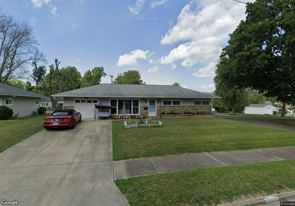
1065 Cornell Dr Alliance, OH 44601
Estimated Value: $140,096 - $191,000
3
Beds
2
Baths
1,104
Sq Ft
$144/Sq Ft
Est. Value
About This Home
This home is located at 1065 Cornell Dr, Alliance, OH 44601 and is currently estimated at $159,524, approximately $144 per square foot. 1065 Cornell Dr is a home located in Stark County with nearby schools including Alliance Early Learning School, Alliance Intermediate School at Northside, and Alliance Middle School.
Ownership History
Date
Name
Owned For
Owner Type
Purchase Details
Closed on
Nov 23, 2005
Sold by
Benner Robert L and Benner June
Bought by
Allison Deane L and Allison Sarah J
Current Estimated Value
Home Financials for this Owner
Home Financials are based on the most recent Mortgage that was taken out on this home.
Original Mortgage
$74,700
Outstanding Balance
$41,154
Interest Rate
6.13%
Mortgage Type
Fannie Mae Freddie Mac
Estimated Equity
$118,370
Purchase Details
Closed on
Nov 3, 1997
Sold by
Umbs Grace
Bought by
Benner Robert L
Create a Home Valuation Report for This Property
The Home Valuation Report is an in-depth analysis detailing your home's value as well as a comparison with similar homes in the area
Home Values in the Area
Average Home Value in this Area
Purchase History
| Date | Buyer | Sale Price | Title Company |
|---|---|---|---|
| Allison Deane L | $83,000 | Union Title Co | |
| Benner Robert L | $71,000 | -- |
Source: Public Records
Mortgage History
| Date | Status | Borrower | Loan Amount |
|---|---|---|---|
| Open | Allison Deane L | $74,700 |
Source: Public Records
Tax History
| Year | Tax Paid | Tax Assessment Tax Assessment Total Assessment is a certain percentage of the fair market value that is determined by local assessors to be the total taxable value of land and additions on the property. | Land | Improvement |
|---|---|---|---|---|
| 2025 | -- | $31,050 | $12,250 | $18,800 |
| 2024 | -- | $31,050 | $12,250 | $18,800 |
| 2023 | $1,171 | $28,460 | $10,780 | $17,680 |
| 2022 | $1,179 | $28,460 | $10,780 | $17,680 |
| 2021 | $1,182 | $28,460 | $10,780 | $17,680 |
| 2020 | $1,107 | $24,890 | $9,380 | $15,510 |
| 2019 | $1,092 | $24,890 | $9,380 | $15,510 |
Source: Public Records
Map
Nearby Homes
- 1534 Fernwood Blvd
- 1156 Parkside Dr
- 1539 Parkway Blvd
- 1718 Fernwood Blvd
- 1310 Overlook Dr
- 1016 Roseland Rd
- 864 W College Rd
- 720 Vincent Blvd
- 1114 Briarcliff Ave
- 1044 Glamorgan St
- 1601 Raywood Rd
- 0 Federal Ave
- 2120 Blenheim Ave
- 664 Fairview Place
- 1235 Spring Ridge Cir Unit 17A
- 203 Glamorgan St
- 2580 Edgewood Ave
- 535 S Mckinley Ave
- 2630 Blenheim Ave
- 2635 Blenheim Ave
- 1075 Cornell Dr
- 1062 Glenwood Dr
- 1076 Glenwood Dr
- 1045 Cornell Dr
- 1048 Glenwood Dr
- 1037 Cornell Dr
- 1454 Fairview Place
- 1066 Cornell Dr
- 1054 Cornell Dr
- 1092 Glenwood Dr
- 1078 Cornell Dr
- 1034 Glenwood Dr
- 1042 Cornell Dr
- 1027 Cornell Dr
- 1094 Cornell Dr
- 1022 Glenwood Dr
- 1069 Glenwood Dr
- 1022 Cornell Dr
- 1055 Glenwood Dr
- 1059 Vincent Blvd
Your Personal Tour Guide
Ask me questions while you tour the home.