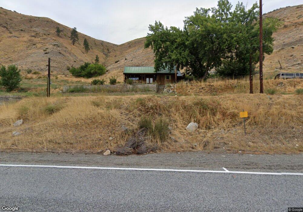
1065 State Route 153 Pateros, WA 98846
Estimated Value: $426,000 - $550,672
3
Beds
1
Bath
1,298
Sq Ft
$368/Sq Ft
Est. Value
About This Home
This home is located at 1065 State Route 153, Pateros, WA 98846 and is currently estimated at $478,224, approximately $368 per square foot. 1065 State Route 153 is a home located in Okanogan County with nearby schools including Pateros Elementary School and Pateros High School.
Ownership History
Date
Name
Owned For
Owner Type
Purchase Details
Closed on
Nov 27, 2018
Sold by
Hendricks Rudy J and Hendricks Robin L
Bought by
Stinson William C
Current Estimated Value
Home Financials for this Owner
Home Financials are based on the most recent Mortgage that was taken out on this home.
Original Mortgage
$202,500
Outstanding Balance
$178,407
Interest Rate
4.8%
Mortgage Type
VA
Estimated Equity
$299,817
Create a Home Valuation Report for This Property
The Home Valuation Report is an in-depth analysis detailing your home's value as well as a comparison with similar homes in the area
Home Values in the Area
Average Home Value in this Area
Purchase History
| Date | Buyer | Sale Price | Title Company |
|---|---|---|---|
| Stinson William C | $240,000 | Inland Professionals Title L |
Source: Public Records
Mortgage History
| Date | Status | Borrower | Loan Amount |
|---|---|---|---|
| Open | Stinson William C | $202,500 |
Source: Public Records
Tax History Compared to Growth
Tax History
| Year | Tax Paid | Tax Assessment Tax Assessment Total Assessment is a certain percentage of the fair market value that is determined by local assessors to be the total taxable value of land and additions on the property. | Land | Improvement |
|---|---|---|---|---|
| 2025 | $2,998 | $404,200 | $111,200 | $293,000 |
| 2024 | $2,998 | $355,400 | $111,200 | $244,200 |
| 2023 | $2,742 | $283,800 | $70,000 | $213,800 |
| 2022 | $2,966 | $243,700 | $70,000 | $173,700 |
| 2021 | $2,537 | $243,700 | $70,000 | $173,700 |
| 2020 | $2,516 | $203,600 | $70,000 | $133,600 |
| 2019 | $2,206 | $203,600 | $70,000 | $133,600 |
| 2018 | $2,617 | $203,600 | $70,000 | $133,600 |
| 2017 | $2,054 | $175,200 | $86,600 | $88,600 |
| 2016 | $2,088 | $175,200 | $86,600 | $88,600 |
| 2015 | $2,231 | $175,200 | $86,600 | $88,600 |
| 2013 | -- | $204,100 | $115,500 | $88,600 |
Source: Public Records
Map
Nearby Homes
- 38A Main St
- 1077 Washington 153
- 251 Burma Rd
- 2 Island View Ln
- 2 River Vista Short Plat
- 2 Methow Plateau Short Plat
- 0 Lot 2 Highland Vista
- 4 Brook Trout Ln
- 1 Lot Highland Plateau
- 1 Terrace View Short Plat
- 15 Sawtooth View Rd
- 0 Flycast Rd Unit NWM2358192
- 6 Cowboy Rd
- 31 Cowboy Rd
- Lot 4 High Ranch Rd
- 29 Barn Dance Dr
- 0 High Ranch Rd
- 15 Cowboy Rd
- 0 Sky Ridge Rd Unit NWM2346303
- 12 Charlie Dr
- 1065 State Hwy 153
- 967 Highway 153
- 4 Riverbend
- 30 Lightning Pine Rd
- 2 Dora Ave
- 9 Cowboy Rd
- 6 Dora Ave
- 28 Lightning Pine Rd
- 967 Highway 153
- 1108 Hwy 153
- 1 Murphy Rd
- 8 Murphy Rd
- 1105 State Route 153
- 1104 State Route 153
- 2 Lot Lightning Pine Rd
- 1101 Washington 153
- 50 Main St
- 1099 Washington 153
- 1472 Washington 153
- 1489 Washington 153