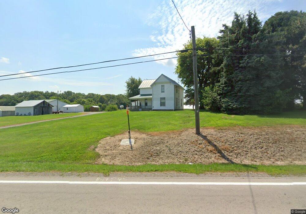
10656 State Route 67 Kenton, OH 43326
Estimated Value: $210,000 - $252,000
2
Beds
1
Bath
1,652
Sq Ft
$142/Sq Ft
Est. Value
About This Home
This home is located at 10656 State Route 67, Kenton, OH 43326 and is currently estimated at $234,101, approximately $141 per square foot. 10656 State Route 67 is a home located in Hardin County with nearby schools including Kenton Elementary School, Kenton Middle School, and Kenton High School.
Ownership History
Date
Name
Owned For
Owner Type
Purchase Details
Closed on
Jul 19, 2024
Sold by
Modd Randall L and Modd Randall Lee
Bought by
Modd Randall Lee and Modd Maria Rose
Current Estimated Value
Purchase Details
Closed on
Jan 6, 2006
Sold by
Longbrake Dorothy L and Mcquowan Barbara J
Bought by
Modd Randall Lee
Home Financials for this Owner
Home Financials are based on the most recent Mortgage that was taken out on this home.
Original Mortgage
$26,730
Interest Rate
6.4%
Mortgage Type
Stand Alone Second
Purchase Details
Closed on
Sep 6, 1995
Bought by
Modd Randall Lee
Create a Home Valuation Report for This Property
The Home Valuation Report is an in-depth analysis detailing your home's value as well as a comparison with similar homes in the area
Home Values in the Area
Average Home Value in this Area
Purchase History
| Date | Buyer | Sale Price | Title Company |
|---|---|---|---|
| Modd Randall Lee | -- | None Listed On Document | |
| Modd Randall Lee | -- | None Available | |
| Modd Randall Lee | $50,000 | -- |
Source: Public Records
Mortgage History
| Date | Status | Borrower | Loan Amount |
|---|---|---|---|
| Previous Owner | Modd Randall Lee | $26,730 |
Source: Public Records
Tax History Compared to Growth
Tax History
| Year | Tax Paid | Tax Assessment Tax Assessment Total Assessment is a certain percentage of the fair market value that is determined by local assessors to be the total taxable value of land and additions on the property. | Land | Improvement |
|---|---|---|---|---|
| 2024 | $1,906 | $43,750 | $10,040 | $33,710 |
| 2023 | $1,906 | $42,790 | $10,040 | $32,750 |
| 2022 | $1,535 | $33,010 | $6,430 | $26,580 |
| 2021 | $1,541 | $33,010 | $6,430 | $26,580 |
| 2020 | $1,337 | $33,010 | $6,430 | $26,580 |
| 2019 | $1,207 | $30,860 | $7,830 | $23,030 |
| 2018 | $1,200 | $30,860 | $7,830 | $23,030 |
| 2017 | $1,153 | $30,860 | $7,830 | $23,030 |
| 2016 | $1,135 | $31,280 | $9,680 | $21,600 |
| 2015 | $1,103 | $31,280 | $9,680 | $21,600 |
| 2014 | $1,139 | $31,280 | $9,680 | $21,600 |
| 2013 | $1,151 | $29,970 | $9,110 | $20,860 |
Source: Public Records
Map
Nearby Homes
- 11279 Township Road 180
- 7370 State Route 67
- 17334 Township Road 95
- 726 Tracy St
- 723 W Lima St Unit 66
- 723 W Lima St Unit 1
- 702 W Franklin St Unit 702 1/2
- 1255 W North St Unit Lot 47
- 320 Letson Ave
- 0 Ohio 309
- 727 S Detroit St
- 368 N Ida St
- 639 S Main St
- 609 W North St
- 424 W Carrol St
- 13450 State Route 292
- 416 Center St
- 219 W Carrol St
- 310 N Market St
- 215 N Main St
- 14325 Township Road 115
- 10571 State Route 67
- 14282 County Road 115
- 14241 Township Road 115
- 14186 Township Road 115
- 10471 Ohio 67
- 14154 Township Road 115
- 10369 State Route 67
- 11067 State Route 67
- 10208 State Route 67
- 14985 County Road 115
- 14696 Tr 119
- 13859 Township Road 115
- 14754 County Road 115
- 15154 County Road 115
- 13817 Township Road 115
- 13755 Township Road 115
- 14885 Township Road 119 Unit 14891
- 13768 Cr