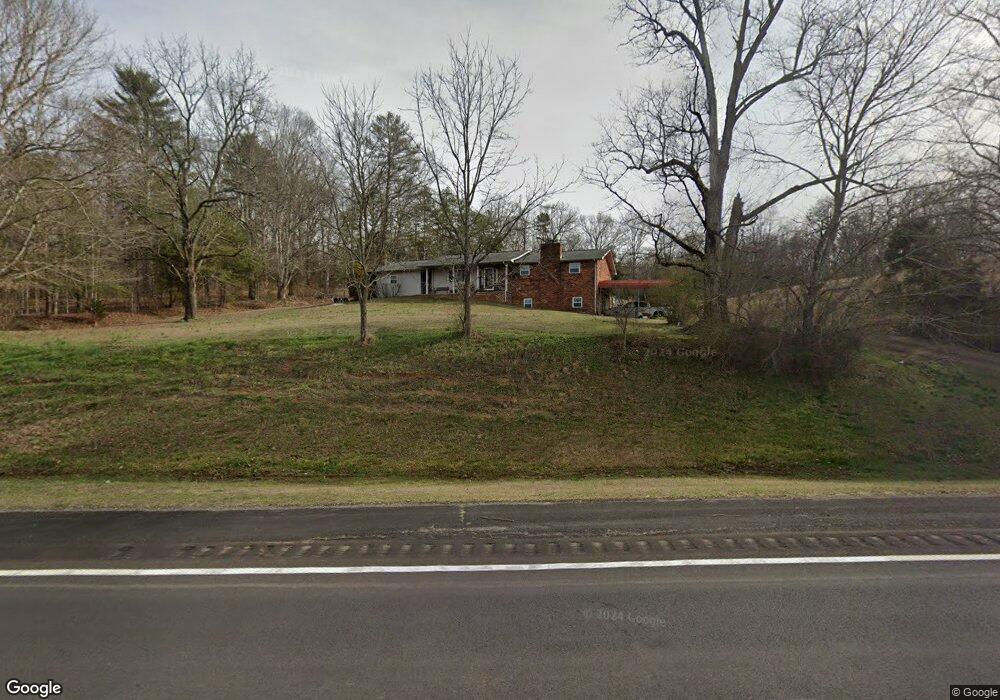
1066 Highway 305 Athens, TN 37303
Estimated Value: $288,000 - $442,000
--
Bed
2
Baths
1,400
Sq Ft
$245/Sq Ft
Est. Value
About This Home
This home is located at 1066 Highway 305, Athens, TN 37303 and is currently estimated at $343,000, approximately $245 per square foot. 1066 Highway 305 is a home located in McMinn County.
Ownership History
Date
Name
Owned For
Owner Type
Purchase Details
Closed on
Jul 27, 1995
Bought by
Hickman Carl
Current Estimated Value
Create a Home Valuation Report for This Property
The Home Valuation Report is an in-depth analysis detailing your home's value as well as a comparison with similar homes in the area
Home Values in the Area
Average Home Value in this Area
Purchase History
| Date | Buyer | Sale Price | Title Company |
|---|---|---|---|
| Hickman Carl | $80,000 | -- |
Source: Public Records
Tax History Compared to Growth
Tax History
| Year | Tax Paid | Tax Assessment Tax Assessment Total Assessment is a certain percentage of the fair market value that is determined by local assessors to be the total taxable value of land and additions on the property. | Land | Improvement |
|---|---|---|---|---|
| 2025 | $550 | $50,850 | $0 | $0 |
| 2024 | $550 | $50,850 | $7,000 | $43,850 |
| 2023 | $550 | $50,850 | $7,000 | $43,850 |
| 2022 | $490 | $31,675 | $4,675 | $27,000 |
| 2021 | $490 | $31,675 | $4,675 | $27,000 |
| 2020 | $486 | $31,425 | $4,675 | $26,750 |
| 2019 | $486 | $31,425 | $4,675 | $26,750 |
| 2018 | $486 | $31,425 | $4,675 | $26,750 |
| 2017 | $465 | $28,775 | $4,675 | $24,100 |
| 2016 | $465 | $28,775 | $4,675 | $24,100 |
| 2015 | -- | $28,625 | $4,700 | $23,925 |
| 2014 | $462 | $28,628 | $0 | $0 |
Source: Public Records
Map
Nearby Homes
- 1112 Highway 305
- 104 County Road 3050
- 124 County Road 3050
- 136 Crescent Cir
- 827 County Unit 187
- 789 County Road 172
- 431 County Road 220
- 169 County Road 188
- 102 County Road 270
- 166 County Road 168
- 353 County Road 170
- 130 County Road 124
- 273 John J Duncan Pkwy
- 0 Denso Dr Unit 1522126
- 0 Denso Dr Unit RTC3014670
- 104 County Road 169
- TBD 45 Ac County Road 280
- 371 County Road 280
- Lot #1 County Road 280
- 0 County Road 280 Unit RTC3035526
- 1080 Highway 305
- 287 Highway 305
- 1086 Highway 305
- 1025 Highway 305
- 1046 Highway 305
- 1100 Highway 305
- 115 County Road 195
- Lot 59 County Road 195
- 59 County Road 195
- 1089 Highway 305
- 0139 State Hwy 305
- 1029 Highway 305
- 1134 Highway 305
- 0000 Highway 305
- Lot 64 County Road 195
- 110 County Road 195
- 1199 County Road 172
- 972 Highway 305
- 119 County Road 212
- 137 County Road 212