Estimated Value: $47,224 - $134,000
2
Beds
1
Bath
1,252
Sq Ft
$65/Sq Ft
Est. Value
About This Home
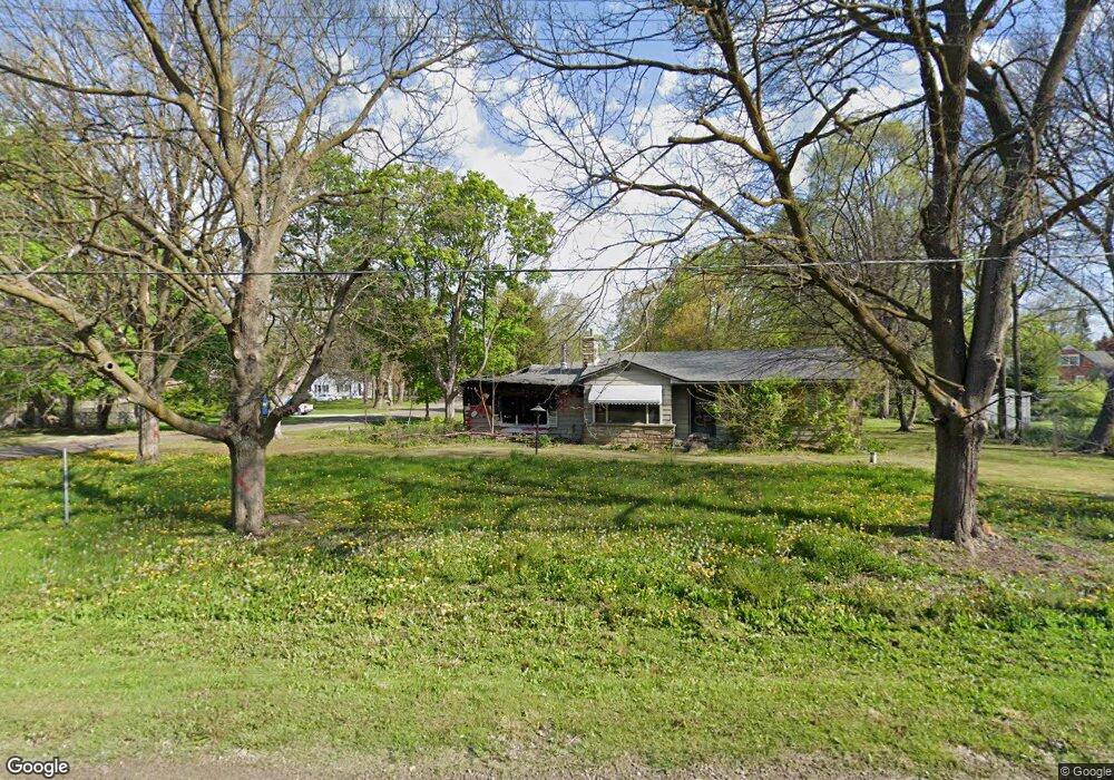
This home is located at 1068 Boyne St, Flint, MI 48507 and is currently estimated at $81,556, approximately $65 per square foot. 1068 Boyne St is a home located in Genesee County with nearby schools including Carman-Ainsworth High School and International Academy of Flint (K-12).
Ownership History
Date
Name
Owned For
Owner Type
Purchase Details
Closed on
Dec 20, 2022
Sold by
Genesee County Treasurer
Bought by
Genesee County Land Bank Authority
Current Estimated Value
Purchase Details
Closed on
Aug 19, 2019
Sold by
The Estate Of Walter W White
Bought by
Abboud Abraham F
Purchase Details
Closed on
Oct 15, 2008
Sold by
Greene Brian
Bought by
Wells Fargo Bank Na
Purchase Details
Closed on
May 20, 2003
Sold by
Guzak Franklin David and Guzak Mary Helen
Bought by
Greene Brian
Purchase Details
Closed on
Jan 13, 1999
Sold by
Guzak Maxine W
Bought by
Guzak Maxine W and Guzak Franklin David
Create a Home Valuation Report for This Property
The Home Valuation Report is an in-depth analysis detailing your home's value as well as a comparison with similar homes in the area
Home Values in the Area
Average Home Value in this Area
Purchase History
| Date | Buyer | Sale Price | Title Company |
|---|---|---|---|
| Genesee County Land Bank Authority | -- | -- | |
| Abboud Abraham F | $30,800 | Cislo Title Co | |
| Wells Fargo Bank Na | $60,720 | None Available | |
| Greene Brian | $106,000 | Cislo Title Company | |
| Guzak Maxine W | -- | -- |
Source: Public Records
Tax History Compared to Growth
Tax History
| Year | Tax Paid | Tax Assessment Tax Assessment Total Assessment is a certain percentage of the fair market value that is determined by local assessors to be the total taxable value of land and additions on the property. | Land | Improvement |
|---|---|---|---|---|
| 2025 | -- | $0 | $0 | $0 |
| 2024 | -- | $0 | $0 | $0 |
| 2023 | $427 | $0 | $0 | $0 |
| 2022 | $133 | $7,700 | $0 | $0 |
| 2021 | $829 | $7,400 | $0 | $0 |
| 2020 | $1,389 | $31,600 | $0 | $0 |
| 2019 | $551 | $28,200 | $0 | $0 |
| 2018 | $1,220 | $26,400 | $0 | $0 |
| 2017 | $1,069 | $26,400 | $0 | $0 |
| 2016 | $1,100 | $23,800 | $0 | $0 |
| 2015 | $925 | $23,800 | $0 | $0 |
| 2014 | $549 | $23,000 | $0 | $0 |
| 2012 | -- | $28,600 | $28,600 | $0 |
Source: Public Records
Map
Nearby Homes
- 3322 Fenton Rd
- 1039 Markham St
- 1122 Markham St
- 1210 Pinehurst Ave
- 1247 Catalina Dr
- 1031 Ingleside Ave
- 1314 Pinehurst Ave
- 1151 Wells St
- 1169 Carman St
- 1318 Ingleside Ave
- 4418 Brunswick Ave
- 1183 Norton St
- 1186 E Decamp St
- 1234 Huron St
- 1310 Huron St
- 1015 Alvord Ave
- 4518 Huckleberry Ln
- 1219 Norton St
- 1230 E Decamp St
- 1826 Greenbrook Ln
- 3385 Phillip Ave
- 3390 Hull St
- 1069 Boyne St
- 3380 Hull St
- 1059 Boyne St
- 3384 Phillip Ave
- 3372 Hull St
- 3398 Phillip Ave
- 3406 Hull St
- 3375 Phillip Ave
- 3369 Phillip Ave
- 1066 W Mandeville St
- 3366 Hull St
- 3414 Hull St
- 3368 Phillip Ave
- 3405 W Mandeville St
- 3405 Manderville St
- 1060 W Mandeville St
- 3407 Hull St
- 3416 Hull Ave