
1068 W Browning Ave Unit B Fresno, CA 93711
Bullard NeighborhoodEstimated payment $1,932/month
Total Views
5,765
2
Beds
2
Baths
1,135
Sq Ft
$260
Price per Sq Ft
Highlights
- Hot Property
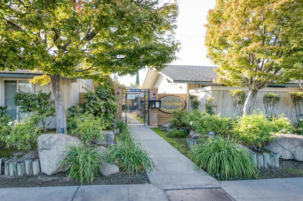
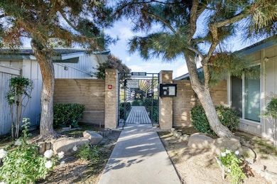
- Gated Community
- Double Pane Windows
- In Ground Pool
- Eat-In Kitchen
- Patio
About This Home
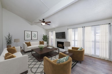
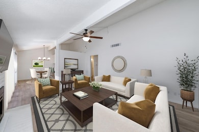
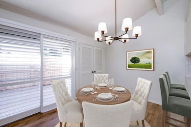
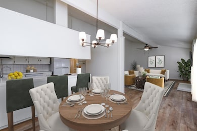
Welcome to this charming single-story condo in a beautifully maintained gated community! Freshly painted and featuring new carpet and vinyl flooring throughout, this home feels bright, clean, and move-in ready. The thoughtful floor plan offers ideal privacy with bedrooms located on opposite sides of the home, creating a comfortable balance of shared and personal space. The open-concept living area connects seamlessly to the kitchen and dining spaces, while indoor laundry and a spacious backyard patio add everyday convenience.The community offers lush, manicured landscaping and a sparkling pool for residents to enjoy. Ideally located near shopping, freeway access, and great restaurants, this home combines comfort, convenience, and low-maintenance living in one of Fresno's most desirable areas. A wonderful opportunity for first-time buyers, downsizers, or investors!
Home Details
Home Type
- Single Family
Est. Annual Taxes
- $1,221
Year Built
- Built in 1970
Lot Details
- 1,221 Sq Ft Lot
- Landscaped
- Front Yard Sprinklers
HOA Fees
- $275 Monthly HOA Fees
Home Design
- Concrete Foundation
- Composition Roof
- Wood Siding
Interior Spaces
- 1,135 Sq Ft Home
- 1-Story Property
- Self Contained Fireplace Unit Or Insert
- Double Pane Windows
- Laundry closet
Kitchen
- Eat-In Kitchen
- Microwave
- Dishwasher
- Disposal
Flooring
- Carpet
- Vinyl
Bedrooms and Bathrooms
- 2 Bedrooms
- 2 Bathrooms
Pool
- In Ground Pool
- Fence Around Pool
Additional Features
- Patio
- Central Heating and Cooling System
Community Details
Overview
- Planned Unit Development
Recreation
- Community Pool
Security
- Gated Community
Map
Create a Home Valuation Report for This Property
The Home Valuation Report is an in-depth analysis detailing your home's value as well as a comparison with similar homes in the area
Home Values in the Area
Average Home Value in this Area
Tax History
| Year | Tax Paid | Tax Assessment Tax Assessment Total Assessment is a certain percentage of the fair market value that is determined by local assessors to be the total taxable value of land and additions on the property. | Land | Improvement |
|---|---|---|---|---|
| 2025 | $1,221 | $96,321 | $24,902 | $71,419 |
| 2023 | $1,198 | $92,583 | $23,936 | $68,647 |
| 2022 | $1,182 | $90,768 | $23,467 | $67,301 |
| 2021 | $1,150 | $88,989 | $23,007 | $65,982 |
| 2020 | $1,145 | $88,078 | $22,772 | $65,306 |
| 2019 | $1,101 | $86,352 | $22,326 | $64,026 |
| 2018 | $1,078 | $84,660 | $21,889 | $62,771 |
| 2017 | $1,060 | $83,001 | $21,460 | $61,541 |
| 2016 | $1,025 | $81,375 | $21,040 | $60,335 |
| 2015 | $1,010 | $80,153 | $20,724 | $59,429 |
| 2014 | $990 | $78,584 | $20,319 | $58,265 |
Source: Public Records
Property History
| Date | Event | Price | List to Sale | Price per Sq Ft |
|---|---|---|---|---|
| 11/12/2025 11/12/25 | For Sale | $295,000 | -- | $260 / Sq Ft |
Source: Fresno MLS
Purchase History
| Date | Type | Sale Price | Title Company |
|---|---|---|---|
| Grant Deed | $58,000 | Stewart Title |
Source: Public Records
Mortgage History
| Date | Status | Loan Amount | Loan Type |
|---|---|---|---|
| Closed | $43,000 | No Value Available |
Source: Public Records
About the Listing Agent
Brian Domingos Jr.’s interest in real estate began in his youth when he traveled with his grandfather to look at investment property. That interest became a lifelong passion after interning at a top real estate brokerage in high school. Since earning his real estate license at the age of 21, Brian has sold hundreds of homes in the Fresno Metropolitan area.
In 2009, Brian launched Premier Valley Realty, now known as Premier Plus Real Estate Company, to build a real estate company that
Brian's Other Listings
Source: Fresno MLS
MLS Number: 639793
APN: 416-410-25
Disclaimer: Certain information contained herein is derived from information provided by parties other than Homes.com. All information provided is deemed reliable, but is not guaranteed to be accurate and should be independently verified.
![]() IDX information is provided exclusively for personal, non-commercial use, and may not be used for any purpose other than to identify prospective properties consumers may be interested in purchasing. Information is deemed reliable but not guaranteed.
IDX information is provided exclusively for personal, non-commercial use, and may not be used for any purpose other than to identify prospective properties consumers may be interested in purchasing. Information is deemed reliable but not guaranteed.
Nearby Homes
- 5610 N Arthur Ave
- 1229 W Bullard Ave Unit 149
- 1229 W Bullard Ave Unit 105
- 5657 N Colonial Ave
- 1159 W San Madele Ave
- 1232 W Mesa Ave
- 1070 W Stuart Ave
- 5386 N Fruit Ave
- 665 W Escalon Ave
- 1486 W Roberts Ave
- 1345 W Escalon Ave
- 1530 W Roberts Ave
- 6260 N Palm Ave Unit 111
- 548 W San Jose Ave
- 1545 W Calimyrna Ave
- 1387 W Sample Ave
- 6337 N Palm Ave
- 5180 N Wishon Ave Unit 103
- 5180 N Wishon Ave Unit 201
- 6300 N Palm Ave Unit 105
- 512 W San Jose Ave
- 657 W Sierra Ave
- 475-585 W Sierra Ave
- 6462 N Remington Ave
- 109 W Barstow Ave
- 1538 W Herndon Ave
- 107 E Sierra Ave
- 7095 N Fruit Ave
- 1237 W Spruce Ave Unit 1239
- 107 W Beechwood Ave
- 7047 N West Ave
- 5155 N Fresno St
- 6158 N Fresno St Unit 101
- 6065 N Augusta St Unit 101
- 4313 N Emerson Ave Unit 102
- 2749 W Fairmont Ave Unit 102
- 4264 N Bengston Ave Unit 102
- 4264 N Bengston Ave Unit 103
- 3970 N Santa fe Ave
- 7135 N Fresno St