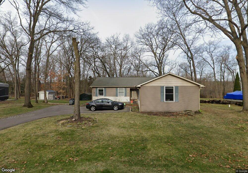
10686 Michael Blvd Pinckney, MI 48169
Estimated Value: $318,871 - $339,000
3
Beds
2
Baths
1,598
Sq Ft
$207/Sq Ft
Est. Value
About This Home
This home is located at 10686 Michael Blvd, Pinckney, MI 48169 and is currently estimated at $331,218, approximately $207 per square foot. 10686 Michael Blvd is a home located in Livingston County with nearby schools including Country Elementary School, Navigator School, and Pathfinder School.
Ownership History
Date
Name
Owned For
Owner Type
Purchase Details
Closed on
Sep 18, 2023
Sold by
Hannula Mark
Bought by
Hannula Mark Andrew and Lobbestail Anna N
Current Estimated Value
Home Financials for this Owner
Home Financials are based on the most recent Mortgage that was taken out on this home.
Original Mortgage
$230,743
Outstanding Balance
$225,412
Interest Rate
6.5%
Mortgage Type
FHA
Estimated Equity
$105,806
Purchase Details
Closed on
Jan 15, 2016
Sold by
Hannula Jamie
Bought by
Hannula Mark
Purchase Details
Closed on
Feb 23, 1996
Sold by
Bullion Kathleen M
Bought by
Hannula Mark G and Hannula L
Home Financials for this Owner
Home Financials are based on the most recent Mortgage that was taken out on this home.
Original Mortgage
$111,145
Interest Rate
7.16%
Mortgage Type
FHA
Create a Home Valuation Report for This Property
The Home Valuation Report is an in-depth analysis detailing your home's value as well as a comparison with similar homes in the area
Home Values in the Area
Average Home Value in this Area
Purchase History
| Date | Buyer | Sale Price | Title Company |
|---|---|---|---|
| Hannula Mark Andrew | $235,000 | None Listed On Document | |
| Hannula Mark | -- | None Available | |
| Hannula Mark G | $112,000 | -- |
Source: Public Records
Mortgage History
| Date | Status | Borrower | Loan Amount |
|---|---|---|---|
| Open | Hannula Mark Andrew | $230,743 | |
| Previous Owner | Hannula Mark G | $111,145 |
Source: Public Records
Tax History Compared to Growth
Tax History
| Year | Tax Paid | Tax Assessment Tax Assessment Total Assessment is a certain percentage of the fair market value that is determined by local assessors to be the total taxable value of land and additions on the property. | Land | Improvement |
|---|---|---|---|---|
| 2025 | $2,918 | $140,110 | $0 | $0 |
| 2024 | $747 | $131,970 | $0 | $0 |
| 2023 | $712 | $120,510 | $0 | $0 |
| 2022 | $1,393 | $97,070 | $0 | $0 |
| 2021 | $2,010 | $97,070 | $0 | $0 |
| 2020 | $1,980 | $94,200 | $0 | $0 |
| 2019 | $1,965 | $89,870 | $0 | $0 |
| 2018 | $1,941 | $75,290 | $0 | $0 |
| 2017 | $1,864 | $75,290 | $0 | $0 |
| 2016 | $1,796 | $69,890 | $0 | $0 |
| 2014 | $1,385 | $64,010 | $0 | $0 |
| 2012 | $1,385 | $53,070 | $0 | $0 |
Source: Public Records
Map
Nearby Homes
- 10499 Michael Blvd
- 10350 Half Moon Dr
- 2540 Lister Dr
- 9993 Tioga Trail Unit 154
- 9970 Whispering Woods Dr
- 3380 McCluskey
- 11410 Tall Shadows Ct
- 9771 Tioga Trail Unit 171
- 3558 Windwheel Point Dr
- 3590 Habitat Trail Unit 25
- 11527 Mcgregor Rd
- 00 Colony
- 11770 Woodview
- 11026 Colony Rd
- 11589 Lombardy Ct
- 11109 Wynns Rd
- 2939 Indian Trail
- 3450 Hooker Rd
- 9418 Charlie Brown Ln
- 4106 Shoreview Ln
- 10666 Michael Blvd
- 10716 Michael Blvd
- 10685 Michael Blvd
- 1011 Michael Blvd
- 10665 Michael Blvd
- 10634 Michael Blvd
- 10736 Michael Blvd
- 2915 Macomb St
- 2924 Harding St
- 2835 Macomb St
- 10635 Michael Blvd
- 2923 Macomb St
- 2936 Harding St
- 2886 Macomb St
- 2848 Macomb St
- 2935 Macomb St
- 10617 Michael Blvd
- 2923 Harding St
- 2948 Harding St
- 2912 Macomb St