Estimated Value: $108,000 - $133,000
3
Beds
1
Bath
1,113
Sq Ft
$107/Sq Ft
Est. Value
About This Home
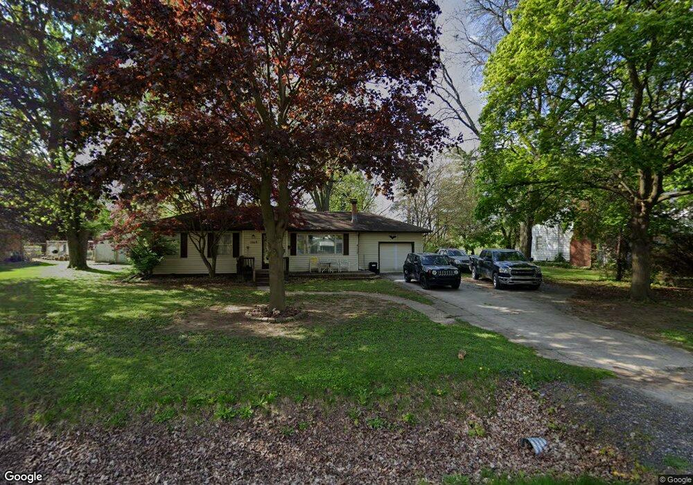
This home is located at 1069 Boyne St, Flint, MI 48507 and is currently estimated at $118,850, approximately $106 per square foot. 1069 Boyne St is a home located in Genesee County with nearby schools including Carman-Ainsworth High School and International Academy of Flint (K-12).
Ownership History
Date
Name
Owned For
Owner Type
Purchase Details
Closed on
Sep 21, 2009
Sold by
Reo Residential Llc
Bought by
Brooks Virgil D and Brooks Rachael A
Current Estimated Value
Purchase Details
Closed on
Feb 11, 2009
Sold by
Shipman Nicholas G and Shipman Brandon C
Bought by
Jpmorgan Chase Bank National Association
Purchase Details
Closed on
Aug 9, 2006
Sold by
Thompson Scott A and Thompson Kim M
Bought by
Shipman Brandon C and Shipman Nicholas G
Create a Home Valuation Report for This Property
The Home Valuation Report is an in-depth analysis detailing your home's value as well as a comparison with similar homes in the area
Home Values in the Area
Average Home Value in this Area
Purchase History
| Date | Buyer | Sale Price | Title Company |
|---|---|---|---|
| Brooks Virgil D | $25,000 | Lighthouse Title Inc | |
| Jpmorgan Chase Bank National Association | $43,000 | None Available | |
| Shipman Brandon C | $102,000 | First American Title Ins Co |
Source: Public Records
Tax History
| Year | Tax Paid | Tax Assessment Tax Assessment Total Assessment is a certain percentage of the fair market value that is determined by local assessors to be the total taxable value of land and additions on the property. | Land | Improvement |
|---|---|---|---|---|
| 2025 | $1,986 | $55,100 | $0 | $0 |
| 2024 | $1,923 | $53,700 | $0 | $0 |
| 2023 | $1,551 | $50,100 | $0 | $0 |
| 2022 | $666 | $42,200 | $0 | $0 |
| 2021 | $1,742 | $36,800 | $0 | $0 |
| 2020 | $1,060 | $32,400 | $0 | $0 |
| 2019 | $1,047 | $29,100 | $0 | $0 |
| 2018 | $1,637 | $27,500 | $0 | $0 |
| 2017 | $1,587 | $27,500 | $0 | $0 |
| 2016 | $1,618 | $25,000 | $0 | $0 |
| 2015 | $1,416 | $25,000 | $0 | $0 |
| 2014 | $1,013 | $24,200 | $0 | $0 |
| 2012 | -- | $27,100 | $27,100 | $0 |
Source: Public Records
Map
Nearby Homes
- 3322 Fenton Rd
- 1019 E Bristol Rd
- 1122 Markham St
- 846 W Hemphill Rd
- 1210 Pinehurst Ave
- 1247 Catalina Dr
- 1125 Ingleside Ave
- 3312 Renault Dr
- 1627 Blackberry Ln
- 1318 Ingleside Ave
- 1121 W Boatfield Ave
- 1034 W Bergin Ave
- 1234 Huron St
- 1310 Huron St
- 1015 Alvord Ave
- 1119 W Bergin Ave
- 912 Huron St
- 4502 Huckleberry Ln
- 1085 W Parkwood Ave
- 1219 Norton St
- 3406 Hull St
- 1059 Boyne St
- 1066 W Mandeville St
- 3414 Hull St
- 1068 Boyne St
- 1060 W Mandeville St
- 3390 Hull St
- 3416 Hull Ave
- 3416 Hull St
- 3407 Hull St
- 1050 W Mandeville St
- 3401 Hull St
- 3385 Phillip Ave
- 3415 Hull St
- 3380 Hull St
- 3372 Hull St
- 3422 Hull St
- 3398 Phillip Ave
- 1044 W Mandeville St
- 3384 Phillip Ave
Your Personal Tour Guide
Ask me questions while you tour the home.