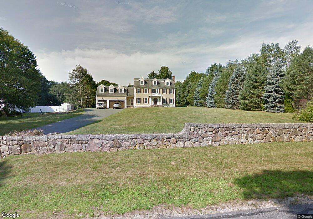
1069 Metropolitan Ave Milton, MA 02186
Brush Hill NeighborhoodEstimated Value: $1,952,202 - $2,546,000
3
Beds
3
Baths
3,391
Sq Ft
$655/Sq Ft
Est. Value
About This Home
This home is located at 1069 Metropolitan Ave, Milton, MA 02186 and is currently estimated at $2,221,551, approximately $655 per square foot. 1069 Metropolitan Ave is a home located in Norfolk County with nearby schools including Milton High School, Boston Preparatory Charter Public School, and Delphi Academy of Boston.
Ownership History
Date
Name
Owned For
Owner Type
Purchase Details
Closed on
Feb 28, 2002
Sold by
Rand Mary J
Bought by
Sullivan Stephen P
Current Estimated Value
Home Financials for this Owner
Home Financials are based on the most recent Mortgage that was taken out on this home.
Original Mortgage
$215,000
Outstanding Balance
$88,483
Interest Rate
6.85%
Mortgage Type
Purchase Money Mortgage
Estimated Equity
$2,133,068
Create a Home Valuation Report for This Property
The Home Valuation Report is an in-depth analysis detailing your home's value as well as a comparison with similar homes in the area
Home Values in the Area
Average Home Value in this Area
Purchase History
| Date | Buyer | Sale Price | Title Company |
|---|---|---|---|
| Sullivan Stephen P | $312,500 | -- |
Source: Public Records
Mortgage History
| Date | Status | Borrower | Loan Amount |
|---|---|---|---|
| Open | Sullivan Stephen P | $215,000 |
Source: Public Records
Tax History Compared to Growth
Tax History
| Year | Tax Paid | Tax Assessment Tax Assessment Total Assessment is a certain percentage of the fair market value that is determined by local assessors to be the total taxable value of land and additions on the property. | Land | Improvement |
|---|---|---|---|---|
| 2025 | $21,032 | $1,896,500 | $509,600 | $1,386,900 |
| 2024 | $20,514 | $1,878,600 | $485,600 | $1,393,000 |
| 2023 | $20,463 | $1,795,000 | $462,800 | $1,332,200 |
| 2022 | $18,764 | $1,504,700 | $462,800 | $1,041,900 |
| 2021 | $17,215 | $1,311,100 | $449,400 | $861,700 |
| 2020 | $16,799 | $1,280,400 | $430,800 | $849,600 |
| 2019 | $16,385 | $1,243,200 | $418,300 | $824,900 |
| 2018 | $17,053 | $1,234,800 | $417,500 | $817,300 |
| 2017 | $15,968 | $1,177,600 | $397,600 | $780,000 |
| 2016 | $15,718 | $1,164,300 | $397,600 | $766,700 |
| 2015 | $17,178 | $1,232,300 | $468,000 | $764,300 |
Source: Public Records
Map
Nearby Homes
- 5 Kinsale Ln
- 3 Kinsale Ln
- 6 Kinsale Ln
- 589 Brush Hill Rd
- 16 Prospect St
- 42 Summit St
- 49 Summit St
- 200 Robbins St
- 350 Blue Hill Ave
- 405 Blue Hill Ave
- 723 Blue Hill Ave
- 141 Beacon St
- 40 Lafayette St
- 0 Truman Pkwy
- 136 Dana Ave
- 755-759 Truman Pkwy
- 114 Dana Ave
- 116 Dana Ave
- 79 Maple St Unit 3
- 485 Blue Hills Pkwy Unit 11
- 1077 Metropolitan Ave
- 1063 Metropolitan Ave
- 1063 Metropolitan Ave Unit 1
- 1047 Metropolitan Ave
- 571 Brush Hill Rd
- 585 Brush Hill Rd
- 45 Brush Hill Ln
- 55 Brush Hill Ln
- 539 Brush Hill Rd
- 6 Elias Ln
- 3 Elias Ln
- 560 Brush Hill Rd
- 1040 Metropolitan Ave
- 568 Brush Hill Rd
- 1031 Metropolitan Ave
- 150 Milton Ave Unit 1
- 540 Brush Hill Rd
- 65 Hills View Rd
- 4 Elias Ln
- 54 Hills View Rd