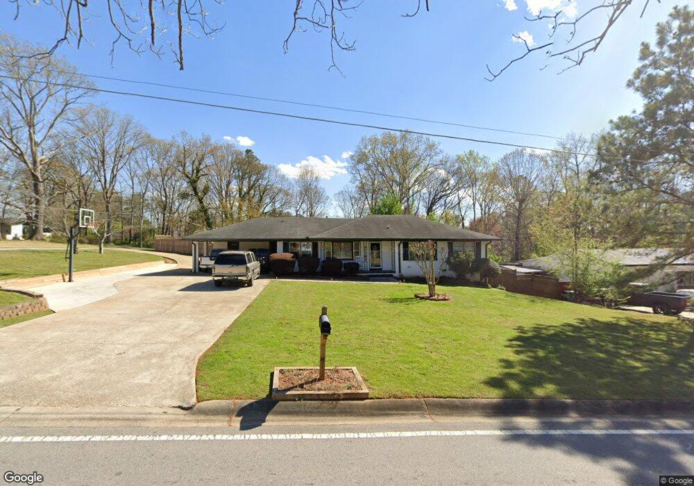
1069 Pair Rd SW Unit 5 Marietta, GA 30060
Southwestern Marietta NeighborhoodEstimated Value: $305,000 - $358,000
4
Beds
3
Baths
1,402
Sq Ft
$232/Sq Ft
Est. Value
About This Home
This home is located at 1069 Pair Rd SW Unit 5, Marietta, GA 30060 and is currently estimated at $324,851, approximately $231 per square foot. 1069 Pair Rd SW Unit 5 is a home located in Cobb County with nearby schools including Birney Elementary School, Floyd Middle School, and Osborne High School.
Ownership History
Date
Name
Owned For
Owner Type
Purchase Details
Closed on
Feb 20, 2005
Sold by
Scarborough Doris V
Bought by
Lopez-Garcia Ageo
Current Estimated Value
Home Financials for this Owner
Home Financials are based on the most recent Mortgage that was taken out on this home.
Original Mortgage
$144,000
Outstanding Balance
$88,082
Interest Rate
9%
Mortgage Type
New Conventional
Estimated Equity
$236,769
Purchase Details
Closed on
Aug 31, 1998
Sold by
Eidson Goldie O
Bought by
Scarborough Doris
Create a Home Valuation Report for This Property
The Home Valuation Report is an in-depth analysis detailing your home's value as well as a comparison with similar homes in the area
Home Values in the Area
Average Home Value in this Area
Purchase History
| Date | Buyer | Sale Price | Title Company |
|---|---|---|---|
| Lopez-Garcia Ageo | $160,000 | -- | |
| Scarborough Doris | $104,000 | -- |
Source: Public Records
Mortgage History
| Date | Status | Borrower | Loan Amount |
|---|---|---|---|
| Open | Lopez-Garcia Ageo | $144,000 |
Source: Public Records
Tax History Compared to Growth
Tax History
| Year | Tax Paid | Tax Assessment Tax Assessment Total Assessment is a certain percentage of the fair market value that is determined by local assessors to be the total taxable value of land and additions on the property. | Land | Improvement |
|---|---|---|---|---|
| 2025 | $4,132 | $137,132 | $28,000 | $109,132 |
| 2024 | $4,135 | $137,132 | $28,000 | $109,132 |
| 2023 | $3,301 | $109,476 | $20,000 | $89,476 |
| 2022 | $2,804 | $92,396 | $10,000 | $82,396 |
| 2021 | $2,804 | $92,396 | $10,000 | $82,396 |
| 2020 | $2,015 | $66,392 | $10,000 | $56,392 |
| 2019 | $2,015 | $66,392 | $10,000 | $56,392 |
| 2018 | $1,937 | $63,816 | $8,000 | $55,816 |
| 2017 | $1,835 | $63,816 | $8,000 | $55,816 |
| 2016 | $1,269 | $44,128 | $8,000 | $36,128 |
| 2015 | $1,300 | $44,128 | $8,000 | $36,128 |
| 2014 | $1,086 | $36,556 | $0 | $0 |
Source: Public Records
Map
Nearby Homes
- 3141 Holbrook Dr SW
- 1108 Byers Dr SW
- 3004 Michael Dr SW
- 959 Old Milford Church Rd SW
- 825 Winfield Ct SW
- 3309 Raes Creek Rd Unit 13
- 3355 Carolina Wren Trail SW
- 971 Canyon Trail SW
- 1020 Hicksmil Dr SW
- 3383 Raes Creek Rd Unit 4
- 800 Grindstone Place SW
- 1427 Lost Bridge Rd
- 2940 Caller Ct SW
- 3408 Double Eagle Dr Unit 28
- 1075 Litchfield Way SW
- 2964 Edgemont Ln SW
- 760 Stone Harbor Pkwy SW
- 1089 Pair Rd SW
- 3161 Doyle Ln SW
- 1070 Amelia Dr SW
- 1101 Pair Rd SW
- 3140 Holbrook Dr SW
- 3185 Doyle Ln SW
- 1102 Byers Dr SW
- 1082 Amelia Dr SW
- 3195 Doyle Ln SW
- 1094 Amelia Dr SW
- 1113 Pair Rd SW
- 3126 Holbrook Dr SW
- 1041 Pair Rd SW
- 3131 Holbrook Dr SW
- 1104 Byers Dr SW
- 1106 Amelia Dr SW
- 1011 Frontier Trail SW
- 1040 Pair Rd SW
- 3207 Doyle Ln SW
- 1125 Pair Rd SW