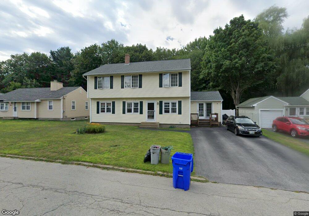
107 Maynard Ave Manchester, NH 03103
Southside NeighborhoodEstimated Value: $546,163 - $580,000
3
Beds
3
Baths
2,144
Sq Ft
$261/Sq Ft
Est. Value
About This Home
This home is located at 107 Maynard Ave, Manchester, NH 03103 and is currently estimated at $560,041, approximately $261 per square foot. 107 Maynard Ave is a home located in Hillsborough County with nearby schools including Jewett Street Elementary School, Southside Middle School, and Manchester Memorial High School.
Ownership History
Date
Name
Owned For
Owner Type
Purchase Details
Closed on
Jun 7, 2024
Sold by
Johnston Jeffrey J and Johnston Sandra S
Bought by
Johnston Ft and Johnston
Current Estimated Value
Purchase Details
Closed on
Dec 29, 1989
Bought by
Johnston Jeffrey J
Create a Home Valuation Report for This Property
The Home Valuation Report is an in-depth analysis detailing your home's value as well as a comparison with similar homes in the area
Home Values in the Area
Average Home Value in this Area
Purchase History
| Date | Buyer | Sale Price | Title Company |
|---|---|---|---|
| Johnston Ft | -- | None Available | |
| Johnston Ft | -- | None Available | |
| Johnston Jeffrey J | -- | -- |
Source: Public Records
Mortgage History
| Date | Status | Borrower | Loan Amount |
|---|---|---|---|
| Previous Owner | Johnston Jeffrey J | $13,000 |
Source: Public Records
Tax History Compared to Growth
Tax History
| Year | Tax Paid | Tax Assessment Tax Assessment Total Assessment is a certain percentage of the fair market value that is determined by local assessors to be the total taxable value of land and additions on the property. | Land | Improvement |
|---|---|---|---|---|
| 2024 | $7,055 | $360,300 | $111,800 | $248,500 |
| 2023 | $6,795 | $360,300 | $111,800 | $248,500 |
| 2022 | $6,572 | $360,300 | $111,800 | $248,500 |
| 2021 | $6,370 | $360,300 | $111,800 | $248,500 |
| 2020 | $6,187 | $250,900 | $77,200 | $173,700 |
| 2019 | $6,102 | $250,900 | $77,200 | $173,700 |
| 2018 | $5,941 | $250,900 | $77,200 | $173,700 |
| 2017 | $5,851 | $250,900 | $77,200 | $173,700 |
| 2016 | $5,806 | $250,900 | $77,200 | $173,700 |
| 2015 | $5,640 | $240,600 | $71,400 | $169,200 |
| 2014 | $5,654 | $240,600 | $71,400 | $169,200 |
| 2013 | $5,454 | $240,600 | $71,400 | $169,200 |
Source: Public Records
Map
Nearby Homes
- 117 Maynard Ave
- 95 Maynard Ave
- 0 Maynard Ave
- 127 Maynard Ave
- 102 Maynard Ave
- 85 Maynard Ave
- 92 Maynard Ave
- 139 Maynard Ave
- 80 Maynard Ave
- 128 Maynard Ave
- 70 Maynard Ave
- 149 Maynard Ave
- 146 Maynard Ave
- 60 Maynard Ave
- 157 Maynard Ave
- 1103 Cilley Rd
- 7 Rosewood Ln
- 53 Maynard Ave
- 1077 Cilley Rd
- 1093 Cilley Rd