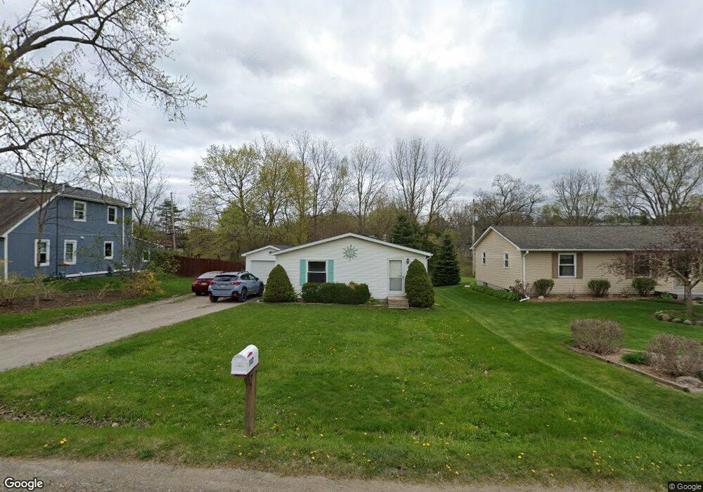
107 Myrtle Ave Ann Arbor, MI 48103
Jackson NeighborhoodEstimated Value: $295,288 - $415,000
3
Beds
3
Baths
1,040
Sq Ft
$324/Sq Ft
Est. Value
About This Home
This home is located at 107 Myrtle Ave, Ann Arbor, MI 48103 and is currently estimated at $337,072, approximately $324 per square foot. 107 Myrtle Ave is a home located in Washtenaw County with nearby schools including Haisley Elementary School, Forsythe Middle School, and Skyline High School.
Ownership History
Date
Name
Owned For
Owner Type
Purchase Details
Closed on
Aug 2, 2013
Sold by
Rusling James T and Rusling Cheryl A
Bought by
Rusling James T and Rusling Cheryl A
Current Estimated Value
Purchase Details
Closed on
Feb 28, 2001
Sold by
Smith William E
Bought by
Rusling James T
Purchase Details
Closed on
Dec 3, 1998
Sold by
Dec Charles D W Mary E
Bought by
Smith William and Smith Elsie W
Purchase Details
Closed on
Aug 12, 1997
Sold by
Decker Charles D
Bought by
Smith William E and Smith Elsie
Create a Home Valuation Report for This Property
The Home Valuation Report is an in-depth analysis detailing your home's value as well as a comparison with similar homes in the area
Home Values in the Area
Average Home Value in this Area
Purchase History
| Date | Buyer | Sale Price | Title Company |
|---|---|---|---|
| Rusling James T | -- | None Available | |
| Rusling James T | $125,900 | -- | |
| Smith William | -- | -- | |
| Smith William E | -- | -- |
Source: Public Records
Tax History
| Year | Tax Paid | Tax Assessment Tax Assessment Total Assessment is a certain percentage of the fair market value that is determined by local assessors to be the total taxable value of land and additions on the property. | Land | Improvement |
|---|---|---|---|---|
| 2025 | $2,141 | $113,500 | $0 | $0 |
| 2024 | $2,090 | $107,600 | $0 | $0 |
| 2023 | $2,008 | $77,600 | $0 | $0 |
| 2022 | $2,895 | $82,000 | $0 | $0 |
| 2021 | $2,755 | $83,900 | $0 | $0 |
| 2020 | $2,820 | $87,500 | $0 | $0 |
| 2019 | $2,609 | $72,600 | $72,600 | $0 |
| 2018 | $2,541 | $70,200 | $0 | $0 |
| 2017 | $2,452 | $75,100 | $0 | $0 |
| 2016 | $1,690 | $66,468 | $0 | $0 |
| 2015 | -- | $66,270 | $0 | $0 |
| 2014 | -- | $64,200 | $0 | $0 |
| 2013 | -- | $64,200 | $0 | $0 |
Source: Public Records
Map
Nearby Homes
- 38 Burton Ave
- 4800 Gullane Dr
- 283 S Zeeb Rd Unit 212
- 5185 Christine Dr
- 5183 Christine Dr
- 5535 Arbor Chase Dr
- 5139 Polo Fields Dr
- 5635 Arbor Chase Dr
- 5610 Arbor Chase Dr
- 5608 Gallery Park Dr
- 4346 Loon Ln
- 4262 Duck Dr
- 4236 Duck Dr
- 4257 Loon Ln
- 4261 Loon Ln
- 4229 Loon Ln
- 3940 Dexter Ann Arbor Rd
- #24 Loon Ln
- #53 Loon Ln
- 5952 Redstone Ct
Your Personal Tour Guide
Ask me questions while you tour the home.