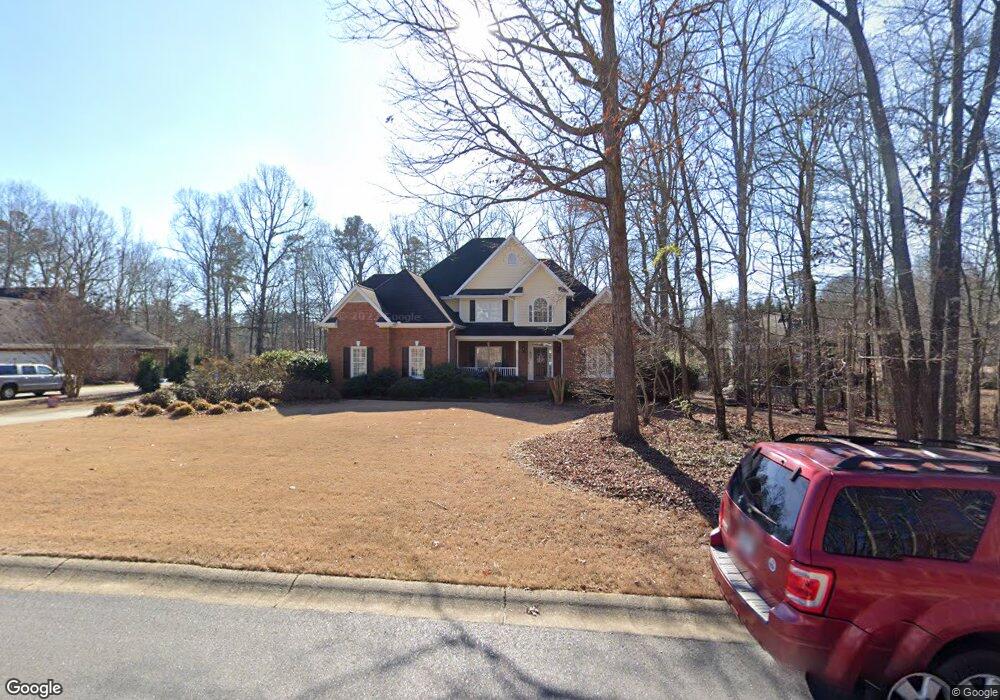
1070 Liberty Ln Bogart, GA 30622
Estimated Value: $640,000 - $755,000
5
Beds
4
Baths
3,131
Sq Ft
$216/Sq Ft
Est. Value
About This Home
This home is located at 1070 Liberty Ln, Bogart, GA 30622 and is currently estimated at $674,873, approximately $215 per square foot. 1070 Liberty Ln is a home located in Oconee County with nearby schools including Rocky Branch Elementary School, Malcom Bridge Middle School, and North Oconee High School.
Ownership History
Date
Name
Owned For
Owner Type
Purchase Details
Closed on
Aug 29, 2003
Sold by
Elias Marybeth A and Elias K
Bought by
Devine Victor K
Current Estimated Value
Purchase Details
Closed on
Mar 16, 2002
Sold by
Elias Mrybeth
Bought by
Crumley William F
Purchase Details
Closed on
Mar 16, 2001
Sold by
Lyle Derrick Dba De
Bought by
Elias Mrybeth
Purchase Details
Closed on
Aug 18, 2000
Sold by
Power Mike
Bought by
Lyle Derrick Dba De
Create a Home Valuation Report for This Property
The Home Valuation Report is an in-depth analysis detailing your home's value as well as a comparison with similar homes in the area
Home Values in the Area
Average Home Value in this Area
Purchase History
| Date | Buyer | Sale Price | Title Company |
|---|---|---|---|
| Devine Victor K | $299,500 | -- | |
| Crumley William F | -- | -- | |
| Elias Mrybeth | $284,700 | -- | |
| Lyle Derrick Dba De | $37,500 | -- |
Source: Public Records
Tax History Compared to Growth
Tax History
| Year | Tax Paid | Tax Assessment Tax Assessment Total Assessment is a certain percentage of the fair market value that is determined by local assessors to be the total taxable value of land and additions on the property. | Land | Improvement |
|---|---|---|---|---|
| 2024 | $3,978 | $209,956 | $30,000 | $179,956 |
| 2023 | $3,931 | $191,612 | $20,000 | $171,612 |
| 2022 | $3,644 | $169,722 | $20,000 | $149,722 |
| 2021 | $3,623 | $156,540 | $20,000 | $136,540 |
| 2020 | $3,463 | $149,406 | $20,000 | $129,406 |
| 2019 | $3,297 | $142,212 | $20,000 | $122,212 |
| 2018 | $3,054 | $129,000 | $20,000 | $109,000 |
| 2016 | $2,974 | $125,648 | $20,000 | $105,648 |
| 2015 | $2,912 | $122,755 | $22,000 | $100,755 |
| 2014 | $2,870 | $118,310 | $22,000 | $96,310 |
| 2013 | -- | $109,858 | $22,000 | $87,858 |
Source: Public Records
Map
Nearby Homes
- 1120 Liberty Ln
- 4100 Monroe Hwy
- 4400 Monroe Hwy Unit PARCEL 1-7
- 3240 Monroe Hwy
- 00 Ruth Jackson Rd
- 0 Ruth Jackson Rd Unit 10582108
- 1180 Summerfield Ln
- 1145 Summerfield Ln
- 1327 Eisenhower Ave
- 1250 Pete Dickens Rd
- 1665 Eisenhower Ave
- 1640 Madison Ct
- 2479 Eisenhower Ave
- 1050 Cobblestone Ln
- 1656 Lincoln Dr
- 1120 Pearl Way
- 0 Monroe Hwy Unit 1025452
- 2130 Keeneland Dr
- 1080 Liberty Ln
- 1021 Glenwood Ln
- 0 Liberty Ln Unit 7484423
- 0 Liberty Ln Unit 7409736
- 0 Liberty Ln Unit 8826469
- 0 Liberty Ln Unit 8289418
- 0 Liberty Ln Unit 8207810
- 0 Liberty Ln
- 1071 Liberty Ln
- 1061 Liberty Ln
- 1100 Liberty Ln
- 1041 Glenwood Ln
- 1020 Glenwood Ln
- 1091 Liberty Ln
- 1051 Liberty Ln
- 1041 Liberty Ln Unit 4
- 1040 Glenwood Ln
- 1111 Liberty Ln
- 1061 Glenwood Ln
- 1030 Liberty Ln