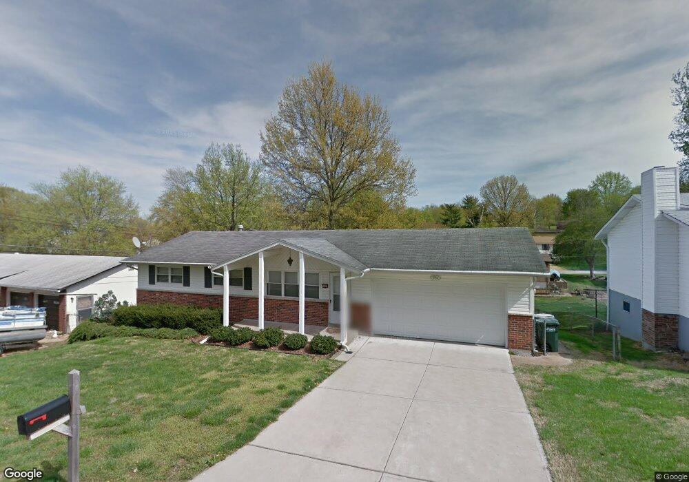
1072 Deborah Dr Arnold, MO 63010
Estimated Value: $215,479 - $278,000
Studio
1
Bath
1,040
Sq Ft
$238/Sq Ft
Est. Value
About This Home
This home is located at 1072 Deborah Dr, Arnold, MO 63010 and is currently estimated at $247,620, approximately $238 per square foot. 1072 Deborah Dr is a home located in Jefferson County with nearby schools including Fox Elementary School, Fox Middle School, and Fox Senior High School.
Ownership History
Date
Name
Owned For
Owner Type
Purchase Details
Closed on
Dec 15, 2025
Sold by
Linton Sondra Annette and Sondra Annette Linton Revocable Trust
Bought by
Chandler Cody Dale and Chandler Cortney
Current Estimated Value
Home Financials for this Owner
Home Financials are based on the most recent Mortgage that was taken out on this home.
Original Mortgage
$233,200
Outstanding Balance
$232,754
Interest Rate
6.22%
Mortgage Type
New Conventional
Estimated Equity
$14,866
Purchase Details
Closed on
Jul 26, 2019
Sold by
Turner Barbara A and Barbara A Turner Revocable Tru
Bought by
Revocabl Linton Sondra Annette and Revocabl Sondra Annette Linton
Purchase Details
Closed on
May 7, 2013
Sold by
Turner Roy Wayne and Turner Barbara A
Bought by
Turner Barbara A and Barbara A Turner Revocable Tru
Create a Home Valuation Report for This Property
The Home Valuation Report is an in-depth analysis detailing your home's value as well as a comparison with similar homes in the area
Home Values in the Area
Average Home Value in this Area
Purchase History
| Date | Buyer | Sale Price | Title Company |
|---|---|---|---|
| Chandler Cody Dale | -- | None Listed On Document | |
| Revocabl Linton Sondra Annette | -- | None Available | |
| Turner Barbara A | -- | None Available |
Source: Public Records
Mortgage History
| Date | Status | Borrower | Loan Amount |
|---|---|---|---|
| Open | Chandler Cody Dale | $233,200 |
Source: Public Records
Tax History
| Year | Tax Paid | Tax Assessment Tax Assessment Total Assessment is a certain percentage of the fair market value that is determined by local assessors to be the total taxable value of land and additions on the property. | Land | Improvement |
|---|---|---|---|---|
| 2025 | $1,357 | $20,800 | $2,700 | $18,100 |
| 2024 | $1,357 | $19,400 | $2,700 | $16,700 |
| 2023 | $1,357 | $19,400 | $2,700 | $16,700 |
| 2022 | $1,383 | $19,400 | $2,700 | $16,700 |
| 2021 | $1,384 | $19,400 | $2,700 | $16,700 |
| 2020 | $1,316 | $17,500 | $2,300 | $15,200 |
| 2019 | $1,320 | $17,500 | $2,300 | $15,200 |
| 2018 | $1,311 | $17,500 | $2,300 | $15,200 |
| 2017 | $1,331 | $17,500 | $2,300 | $15,200 |
| 2016 | $1,114 | $15,700 | $2,300 | $13,400 |
| 2015 | $1,117 | $15,700 | $2,300 | $13,400 |
| 2013 | -- | $15,200 | $2,300 | $12,900 |
Source: Public Records
Map
Nearby Homes
- 2631 Georgia Dr
- 672 Berrywine Ln
- 1258 Arnold Tenbrook Rd
- 866 Sunset Dr
- 0 Unknown Unit 22001740
- 0 Unknown Unit 22071117
- 0 Unknown Unit 22001730
- 0 Unknown Unit 21017758
- 2721 Rose Dr
- 747 Esther Dr
- 2929 Tenbrook Rd
- 851 Morningside Ln
- 1294 Windcrest Cir
- 2123 Berrywood Ct
- 3.5 Acres - Ridge Dr
- 447 June Dr
- 2266 Starling Airport Rd
- 490 Electra Dr
- 638 Jeffco Blvd
- 0000 Botanical Dr
Your Personal Tour Guide
Ask me questions while you tour the home.